File:Yangshan Deep-Water Port locator map.png
Jump to navigation
Jump to search
No higher resolution available.
Yangshan_Deep-Water_Port_locator_map.png (486 × 413 pixels, file size: 164 KB, MIME type: image/png)
Captions
Captions
Add a one-line explanation of what this file represents
Summary[edit]
| Description |
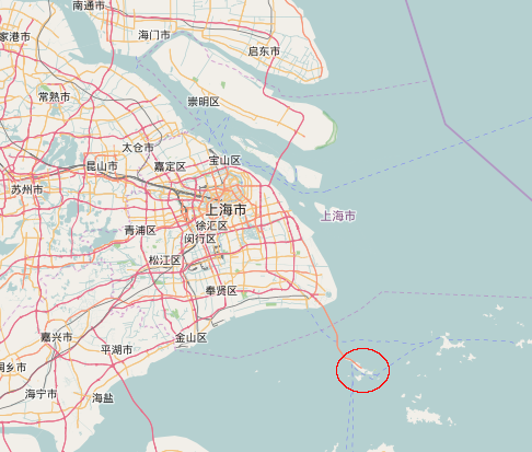
English: Location of the en:Yangshan Port/Yangshan Deep-Water Port.
Deutsch: Lage des de:Tiefwasserhafen Yangshan.
日本語: ja:洋山深水港
Nederlands: nl:Yangshan Containerterminal
Русский: ru:Порт Яншань
中文:zh:洋山深水港 |
|||
| Date | ||||
| Source | Own work | |||
| Author | ScotXW | |||
| Permission (Reusing this file) |
|
Licensing[edit]
I, the copyright holder of this work, hereby publish it under the following license:
| This file is made available under the Creative Commons CC0 1.0 Universal Public Domain Dedication. | |
| The person who associated a work with this deed has dedicated the work to the public domain by waiving all of their rights to the work worldwide under copyright law, including all related and neighboring rights, to the extent allowed by law. You can copy, modify, distribute and perform the work, even for commercial purposes, all without asking permission.
|
File history
Click on a date/time to view the file as it appeared at that time.
| Date/Time | Thumbnail | Dimensions | User | Comment | |
|---|---|---|---|---|---|
| current | 15:01, 18 September 2016 | | 486 × 413 (164 KB) | ScotXW (talk | contribs) | Exported a png from OpenStreetMap |
You cannot overwrite this file.
File usage on Commons
The following page uses this file:
File usage on other wikis
The following other wikis use this file:
- Usage on bn.wikipedia.org
- Usage on de.wikipedia.org
- Usage on fr.wikipedia.org
- Usage on id.wikipedia.org
- Usage on it.wikipedia.org
- Usage on ja.wikipedia.org
- Usage on ru.wikipedia.org
- Usage on vi.wikipedia.org
- Usage on zh.wikipedia.org