File:World Map Index of perception of corruption 2010.svg
Jump to navigation
Jump to search

Size of this PNG preview of this SVG file: 800 × 406 pixels. Other resolutions: 320 × 162 pixels | 640 × 325 pixels | 1,024 × 520 pixels | 1,280 × 650 pixels | 2,560 × 1,299 pixels | 940 × 477 pixels.
Original file (SVG file, nominally 940 × 477 pixels, file size: 1.63 MB)
Captions
Captions
Add a one-line explanation of what this file represents
Summary[edit]
| Description |
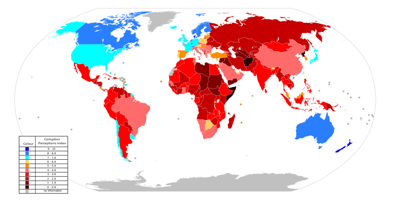
Español: Mapa mundial Indice de Percepción de corrupción: en azul están los países con menor corrupción, en rojo los de mayor corrupción.
English: World Map of the Corruption Perceptions Index: in bluer are the countries with less corruption, in redder the ones with more corruption.
Français : Carte du monde de la perception de la corruption: en bleu, les pays les moins corrompus, en rouge sombre, les plus corrompus.
Nederlands: Wereldkaart van perceptie van de corruptie: in het blauw zijn de landen met minder corruptie, in het rood de landen met meer corruptie.
বাংলা: বিশ্বব্যাপী শতাংশে আন্তর্জাতিক দুর্নীতি সূচকের মানচিত্র, নীল রঙের দেশগুলো কম দুর্নীতি প্রবণ এবং লাল রঙের দেশ গুলো বেশী দুর্নীতি প্রবণ।
Українська: Карта світу, що показує Індекс сприйняття корупції. Найменш корумповані країни показані синім кольором, найбільш корумповані — темно-червоним.
Русский: Карта мира Индекс принятия коррупции. Синим цветом показаны страны с наименьшим уровнем коррупции, наибольшим уровнем - темно-красным. |
| Source | Derivative of File:World Map Index of perception of corruption 2009.svg |
| Author | derivate work: Talkstosocks |
Licensing[edit]
| I, the copyright holder of this work, release this work into the public domain. This applies worldwide. In some countries this may not be legally possible; if so: I grant anyone the right to use this work for any purpose, without any conditions, unless such conditions are required by law. |
File history
Click on a date/time to view the file as it appeared at that time.
| Date/Time | Thumbnail | Dimensions | User | Comment | |
|---|---|---|---|---|---|
| current | 20:00, 6 December 2020 | | 940 × 477 (1.63 MB) | Rubin16 (talk | contribs) | File uploaded using svgtranslate tool (https://svgtranslate.toolforge.org/). Added translation for ru. |
| 04:26, 4 January 2014 |  | 940 × 477 (1.68 MB) | Spesh531 (talk | contribs) | 2013 | |
| 16:34, 7 December 2012 |  | 863 × 443 (1.66 MB) | Spesh531 (talk | contribs) | uncovering easter islands and fixing macau and hong kong | |
| 16:28, 7 December 2012 |  | 863 × 443 (1.66 MB) | Spesh531 (talk | contribs) | reuploading from the current microstates map, probably smaller | |
| 15:04, 7 December 2012 |  | 940 × 477 (1.68 MB) | Spesh531 (talk | contribs) | Afghanistan is tied with Somalia and North Korea: 0.8 | |
| 22:23, 6 December 2012 |  | 940 × 477 (1.68 MB) | Spesh531 (talk | contribs) | 2012 | |
| 15:13, 28 October 2010 |  | 940 × 477 (1.67 MB) | Kurzon (talk | contribs) | Added more blue for better contrast | |
| 11:13, 28 October 2010 |  | 940 × 477 (1.67 MB) | Kurzon (talk | contribs) | Changed the green shades to blue to accommodate people with red-green color blindness, after noticing this complaint in the Discussion pages of the 2009 version. | |
| 20:47, 26 October 2010 |  | 940 × 477 (1.67 MB) | Kurzon (talk | contribs) | {{Information |Description={{en|1=Updated 2009 map based on the report of Transparency International http://www.transparency.org/policy_research/surveys_indices/cpi/2010/results}} |Source=Derivative of 2009 map |Author=derivate of Talkstosocks |Date= |Pe |
You cannot overwrite this file.
File usage on Commons
The following 4 pages use this file:
File usage on other wikis
The following other wikis use this file:
- Usage on ar.wikipedia.org
- Usage on ast.wikipedia.org
- Usage on be.wikipedia.org
- Usage on bg.wikipedia.org
- Usage on ca.wikipedia.org
- Usage on de.wikipedia.org
- Usage on en.wikipedia.org
- Usage on es.wikipedia.org
- Usage on es.wikinews.org
- Usage on fa.wikipedia.org
- Usage on fr.wikipedia.org
- Usage on hr.wikipedia.org
- Usage on id.wikipedia.org
- Usage on it.wikipedia.org
- Usage on it.wikinews.org
- Usage on ka.wikipedia.org
- Usage on kn.wikipedia.org
- Usage on lt.wikipedia.org
- Usage on nn.wikipedia.org
- Usage on pl.wikipedia.org
- Usage on pt.wikipedia.org
- Usage on pt.wikinews.org
- Usage on ro.wikipedia.org
- Usage on ru.wikinews.org
- Usage on sh.wikipedia.org
- Usage on tg.wikipedia.org
- Usage on tl.wikipedia.org
- Usage on tr.wikipedia.org
- Usage on ur.wikipedia.org
View more global usage of this file.