File:Whidbey Island NAS Airport Diagram.jpg
Jump to navigation
Jump to search

Size of this preview: 390 × 599 pixels. Other resolutions: 156 × 240 pixels | 313 × 480 pixels | 500 × 768 pixels | 667 × 1,024 pixels | 1,334 × 2,048 pixels | 3,225 × 4,950 pixels.
Original file (3,225 × 4,950 pixels, file size: 1.03 MB, MIME type: image/jpeg)
Captions
Captions
Add a one-line explanation of what this file represents
Summary[edit]
| Description |
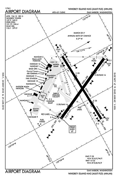
English: Naval Air Station Whidbey Island (NASWI) Airport Diagram, produced by the Federal Aviation Administration in March 2017 |
| Date | |
| Source | http://aeronav.faa.gov/d-tpp/1806/00451AD.PDF |
| Author | Federal Aviation Administration |
Licensing[edit]
This image or file is a work of a Federal Aviation Administration employee, taken or made as part of that person's official duties. As a work of the U.S. federal government, the image is in the public domain in the United States.
|
 |
File history
Click on a date/time to view the file as it appeared at that time.
| Date/Time | Thumbnail | Dimensions | User | Comment | |
|---|---|---|---|---|---|
| current | 03:32, 31 May 2018 | | 3,225 × 4,950 (1.03 MB) | A Common Porpoise (talk | contribs) | User created page with UploadWizard |
You cannot overwrite this file.
File usage on Commons
The following 4 pages use this file:
File usage on other wikis
The following other wikis use this file:
- Usage on en.wikipedia.org