File:Welsh devolution referendum, 2011 v2.svg
Jump to navigation
Jump to search

Size of this PNG preview of this SVG file: 502 × 600 pixels. Other resolutions: 201 × 240 pixels | 402 × 480 pixels | 643 × 768 pixels | 857 × 1,024 pixels | 1,714 × 2,048 pixels | 524 × 626 pixels.
Original file (SVG file, nominally 524 × 626 pixels, file size: 219 KB)
Captions
Captions
Add a one-line explanation of what this file represents
Summary[edit]
| Description |
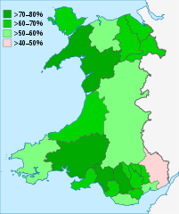
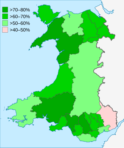
English: Map of the Welsh devolution referendum, 2011 (percentage of ""Yes" votes).
Deutsch: Ergebisse des Referendums in Wales 2011 (Prozent „Ja“-Stimmen). |
||
| Date | |||
| Source |
This file was derived from: Welsh devolution referendum, 2011.svg by MrPenguin20 |
||
| Author | Furfur | ||
| Permission (Reusing this file) |
I, the copyright holder of this work, hereby publish it under the following licenses:
This file is licensed under the Creative Commons Attribution-Share Alike 4.0 International license.
You may select the license of your choice. |
||
| SVG development | This map was created with Adobe Illustrator. |

File history
Click on a date/time to view the file as it appeared at that time.
| Date/Time | Thumbnail | Dimensions | User | Comment | |
|---|---|---|---|---|---|
| current | 18:22, 22 May 2021 | | 524 × 626 (219 KB) | Furfur (talk | contribs) | == {{int:filedesc}} == {{Information |Description={{User:Medium69/Traduction}} {{en|1=Map of the Welsh devolution referendum, 2011 (percentage of ""Yes" votes).}} {{de|1=Ergebisse des Referendums in Wales 2011 (Prozent „Ja“-Stimmen).}} |Source={{Derived from|Welsh devolution referendum, 2011.svg|by=MrPenguin20}}{{Derived from|Wales Powys locator map.svg|by=NordNordWest}} data source: [https://senedd.wales/media/gclkwa5f/11-017-english.pdf Results of the National Assembly for Wales Referendum... |
You cannot overwrite this file.
File usage on Commons
The following page uses this file:
File usage on other wikis
The following other wikis use this file:
- Usage on de.wikipedia.org