File:WalesRef97YesVote.png
Jump to navigation
Jump to search

Size of this preview: 533 × 599 pixels. Other resolutions: 213 × 240 pixels | 427 × 480 pixels | 882 × 992 pixels.
Original file (882 × 992 pixels, file size: 25 KB, MIME type: image/png)
Captions
Captions
Add a one-line explanation of what this file represents
Summary[edit]
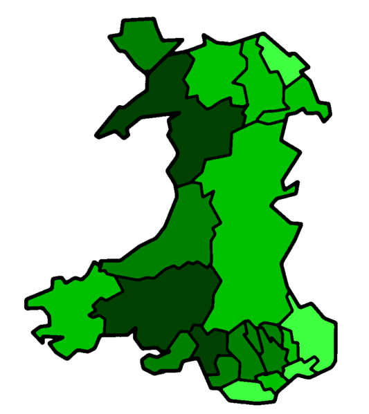
This is a map of the result of the 1997 referendum on devolution held in Wales on 18 Sept 1997. This map shows all 22 unitary authorities colour-coded by their percentage of votes for the Welsh Assembly (the darker colour shows a strong vote for the Assembly, while the lighter colours shows a weak vote for the Assembly). The map has been made from Morwen's blank map of Wales. As the original map was GFDL, this map is GFDL as well. The figures used to compile the map are from the BBC.
Key[edit]
30.1-39.9% of vote
40.1-49.9% of vote
50.1-59.9% of vote
60.1%+ of vote
Licensing[edit]

|
Permission is granted to copy, distribute and/or modify this document under the terms of the GNU Free Documentation License, Version 1.2 or any later version published by the Free Software Foundation; with no Invariant Sections, no Front-Cover Texts, and no Back-Cover Texts. A copy of the license is included in the section entitled GNU Free Documentation License. |
| This file is licensed under the Creative Commons Attribution-Share Alike 3.0 Unported license. | ||
| ||
| This licensing tag was added to this file as part of the GFDL licensing update. |
File history
Click on a date/time to view the file as it appeared at that time.
| Date/Time | Thumbnail | Dimensions | User | Comment | |
|---|---|---|---|---|---|
| current | 03:21, 16 August 2006 | | 882 × 992 (25 KB) | Hoshie (talk | contribs) | ==Summary== This is a map of the result of the 1997 referendum on devolution held in Wales on 18 Sept 1997. This map shows all 22 unitary authorities colour-coded by their percentage of votes for the Welsh Assembly (the darker colour shows a strong vote |
You cannot overwrite this file.
File usage on Commons
The following page uses this file: