File:WW2-Holocaust-Europe.png

Original file (1,310 × 1,090 pixels, file size: 639 KB, MIME type: image/png)
Captions
Captions
Summary[edit]
| Description |
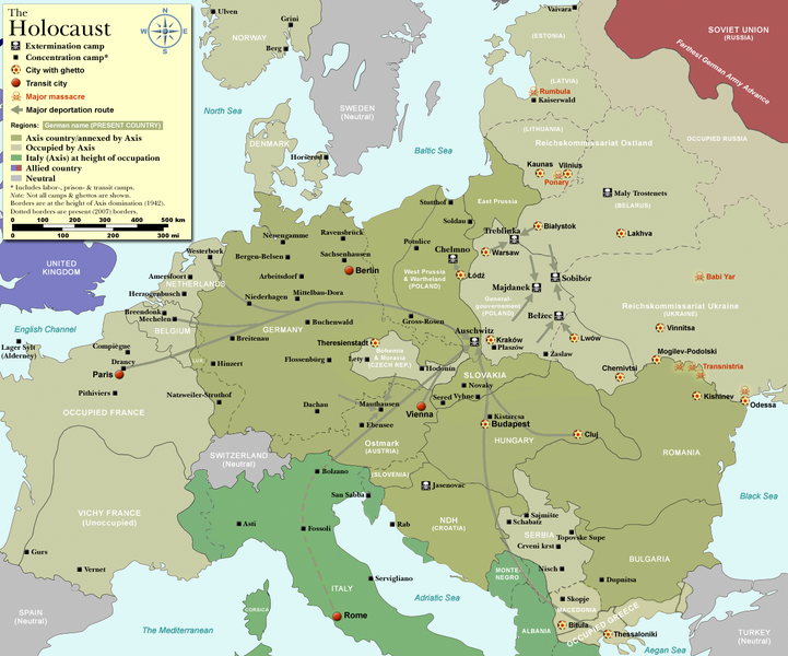
Map of the Holocaust in Europe during World War II, 1939-1945.
|
| Date | |
| Source | Self-made by User:Dna-Dennis, using information from USHMM & Wikipedia. |
| Author | User:Dna-Dennis |
| Permission (Reusing this file) |
CC, see below. The map is completely unrestricted for any Wikipedia/Wikimedia project. |
| Other versions |
[]
|


.png)


.png)


.png)

|
File:WW2 Holocaust Europe map-fr.svg is a vector version of this file. It should be used in place of this PNG file when not inferior.
File:WW2-Holocaust-Europe.png → File:WW2 Holocaust Europe map-fr.svg
For more information, see Help:SVG. |
 |
Licensing[edit]
- You are free:
- to share – to copy, distribute and transmit the work
- to remix – to adapt the work
- Under the following conditions:
- attribution – You must give appropriate credit, provide a link to the license, and indicate if changes were made. You may do so in any reasonable manner, but not in any way that suggests the licensor endorses you or your use.
File history
Click on a date/time to view the file as it appeared at that time.
| Date/Time | Thumbnail | Dimensions | User | Comment | |
|---|---|---|---|---|---|
| current | 13:57, 29 October 2009 | | 1,310 × 1,090 (639 KB) | Flying Saucer (talk | contribs) | moved Vaivara to it's right place |
| 03:41, 20 December 2007 |  | 1,310 × 1,090 (826 KB) | Dna-webmaster~commonswiki (talk | contribs) | new version without "Axis cooperating" in legend | |
| 02:00, 20 December 2007 |  | 1,310 × 1,090 (824 KB) | Dna-webmaster~commonswiki (talk | contribs) | Now entire West Prussia and Wartheland is included in the Third Reich | |
| 16:42, 19 December 2007 |  | 1,310 × 1,090 (828 KB) | Dna-webmaster~commonswiki (talk | contribs) | still not Da Vinci, but errors have been corrected (Germany borders West/East), West & East Prussia borders/coloring and Poland General Government corrected borders. | |
| 10:46, 17 December 2007 |  | 1,310 × 1,090 (825 KB) | Dna-webmaster~commonswiki (talk | contribs) | new map with 1942 borders, not Da Vinci, but here it goes... | |
| 13:32, 19 October 2007 |  | 1,310 × 1,090 (766 KB) | Dna-webmaster~commonswiki (talk | contribs) | and another update | |
| 12:21, 19 October 2007 |  | 1,310 × 1,090 (771 KB) | Dna-webmaster~commonswiki (talk | contribs) | quick fix | |
| 12:11, 19 October 2007 |  | 1,310 × 1,090 (771 KB) | Dna-webmaster~commonswiki (talk | contribs) | {{Information |Description=Map of the Holocaust in Europe during World War II, 1939-1945. <br> This map shows all extermination camps (or ''death camps''), most major concentration camps, work camps, prison camps, ghettos, major deportation routes and maj |
You cannot overwrite this file.
File usage on Commons
The following 32 pages use this file:
- Atlas of World War II
- Commons:Files used on the AARoads Wiki/72
- File:WW2-Holocaust-Europe-2007Borders.png
- File:WW2-Holocaust-Europe-2007Borders DE.png
- File:WW2-Holocaust-Europe-he.png
- File:WW2-Holocaust-Europe.png
- File:WW2-Holocaust-Europe (cropped).png
- File:WW2-Holocaust-Europe DE.png
- File:WW2-Holocaust-Europe DE 2.png
- File:WW2-Holocaust-Europe blank.png
- File:WW2-Holocaust-Poland-ru.png
- File:WW2-Holocaust-Poland-ukr.jpg
- File:WW2-Holocaust-Poland.PNG
- File:WW2-Holocaust-Poland (Français).png
- File:WW2-Holocaust-Poland (without comment).png
- File:WW2-Holocaust-Poland big legend.PNG
- File:WW2-Holocaust-ROstland.PNG
- File:WW2-Holocaust-ROstland big legend.PNG
- File:WW2-Holocaust-Ukraine.PNG
- File:WW2-Holocaust-Ukraine big legend.PNG
- File:WW2-Zagłada-Żydów-Polska.png
- File:WW2 Holocaust Europe N-E map-fr.svg
- File:WW2 Holocaust Europe map-blank.svg
- File:WW2 Holocaust Europe map-es.svg
- File:WW2 Holocaust Europe map-fr.svg
- File:WW2 Holocaust Europe map-it.svg
- File:WW2 Holocaust Europe map-pt.svg
- File:WW2 Holocaust Europe map-zh-hans.svg
- File:WW2 Holocaust Poland map-fr.svg
- File:Холокост в Европе.png
- File talk:WW2-Holocaust-Poland.PNG
- Template:Other versions/WW2 Holocaust Europe map
File usage on other wikis
The following other wikis use this file:
- Usage on af.wikipedia.org
- Usage on ar.wikipedia.org
- Usage on az.wikipedia.org
- Usage on be-tarask.wikipedia.org
- Usage on be.wikipedia.org
- Usage on bn.wikipedia.org
- Usage on ca.wikipedia.org
- Usage on cs.wikipedia.org
- Usage on de.wikipedia.org
- Usage on el.wikipedia.org
- Usage on en.wikipedia.org
- Auschwitz concentration camp
- Extermination camp
- Sobibor extermination camp
- Drancy internment camp
- White Buses
- Vel' d'Hiv Roundup
- Template:Image frame
- German war crimes
- René Bousquet
- Holocaust trains
- Portal:Genocide/Selected article
- Portal:Genocide/Selected article/8
- Mechelen transit camp
- User:Dna-webmaster/Projects
- Jewish ghettos in Europe
- List of Jewish ghettos in Europe during World War II
- Template:Image frame/doc
- User:Jnestorius/Resources
- Wikipedia:Featured picture candidates/January-2015
- Wikipedia:Featured picture candidates/Map of the Holocaust in Europe
- The Holocaust in Hungary
- Emigration of Jews from Nazi Germany and German-occupied Europe
- Talk:The Holocaust/Archive 31
- Template:Image frame/sandbox
- Reich Security Head Office Referat IV B4
- Genocides in history (World War I through World War II)
- User:Buidhe/fork
- Usage on en.wikibooks.org
- Usage on es.wikipedia.org
- Usage on fa.wikipedia.org
- Usage on fi.wikipedia.org
- Usage on fi.wikibooks.org
- Usage on fr.wikipedia.org
View more global usage of this file.