File:Vredefort crater cross section 2.png
Jump to navigation
Jump to search
Size of this preview: 799 × 246 pixels. Other resolutions: 320 × 99 pixels | 640 × 197 pixels | 1,024 × 315 pixels | 1,280 × 394 pixels | 3,324 × 1,024 pixels.
Original file (3,324 × 1,024 pixels, file size: 131 KB, MIME type: image/png)
Captions
Captions
Add a one-line explanation of what this file represents
Summary[edit]
| Description |
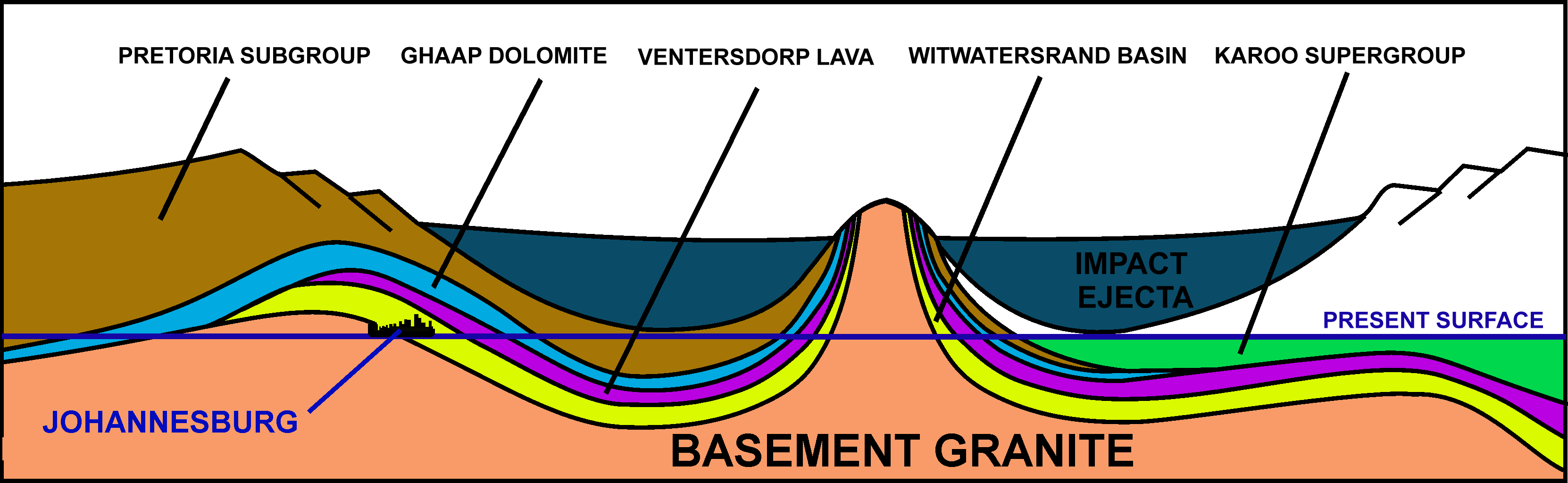
English: A diagrammatic NE-SW cross section through the Vredefort crater showing how the underlying strata were distorted by the meteor impact. |
| Date | |
| Source | Own work |
| Author | Oggmus |

|
This geology image could be re-created using vector graphics as an SVG file. This has several advantages; see Commons:Media for cleanup for more information. If an SVG form of this image is available, please upload it and afterwards replace this template with
{{vector version available|new image name}}.
It is recommended to name the SVG file “Vredefort crater cross section 2.svg”—then the template Vector version available (or Vva) does not need the new image name parameter. |
Licensing[edit]
I, the copyright holder of this work, hereby publish it under the following license:
This file is licensed under the Creative Commons Attribution-Share Alike 3.0 Unported license.
- You are free:
- to share – to copy, distribute and transmit the work
- to remix – to adapt the work
- Under the following conditions:
- attribution – You must give appropriate credit, provide a link to the license, and indicate if changes were made. You may do so in any reasonable manner, but not in any way that suggests the licensor endorses you or your use.
- share alike – If you remix, transform, or build upon the material, you must distribute your contributions under the same or compatible license as the original.
File history
Click on a date/time to view the file as it appeared at that time.
| Date/Time | Thumbnail | Dimensions | User | Comment | |
|---|---|---|---|---|---|
| current | 15:15, 17 March 2015 | 3,324 × 1,024 (131 KB) | Oggmus (talk | contribs) | added a diagrammatic image of Johannesburg in the appropriate position on the "present surface", so that the reader is not entirely dependent on the verbal description (in the legend) of where this city is located. | |
| 06:16, 9 February 2014 | 3,324 × 1,024 (135 KB) | Oggmus (talk | contribs) | User created page with UploadWizard |
You cannot overwrite this file.
File usage on Commons
The following page uses this file:
File usage on other wikis
The following other wikis use this file:
- Usage on ar.wikipedia.org
- Usage on avk.wikipedia.org
- Usage on ca.wikipedia.org
- Usage on en.wikipedia.org
- Usage on id.wikipedia.org
- Usage on ja.wikipedia.org
- Usage on mt.wikipedia.org
- Usage on si.wikipedia.org
- Usage on sl.wikipedia.org
- Usage on sv.wikipedia.org
- Usage on www.wikidata.org