File:Vatta zhutthu tamil 2ndBC karadikal madurai tamil.jpg
Original file (4,000 × 3,000 pixels, file size: 6.64 MB, MIME type: image/jpeg)
Captions
Captions
Summary[edit]
| Description |
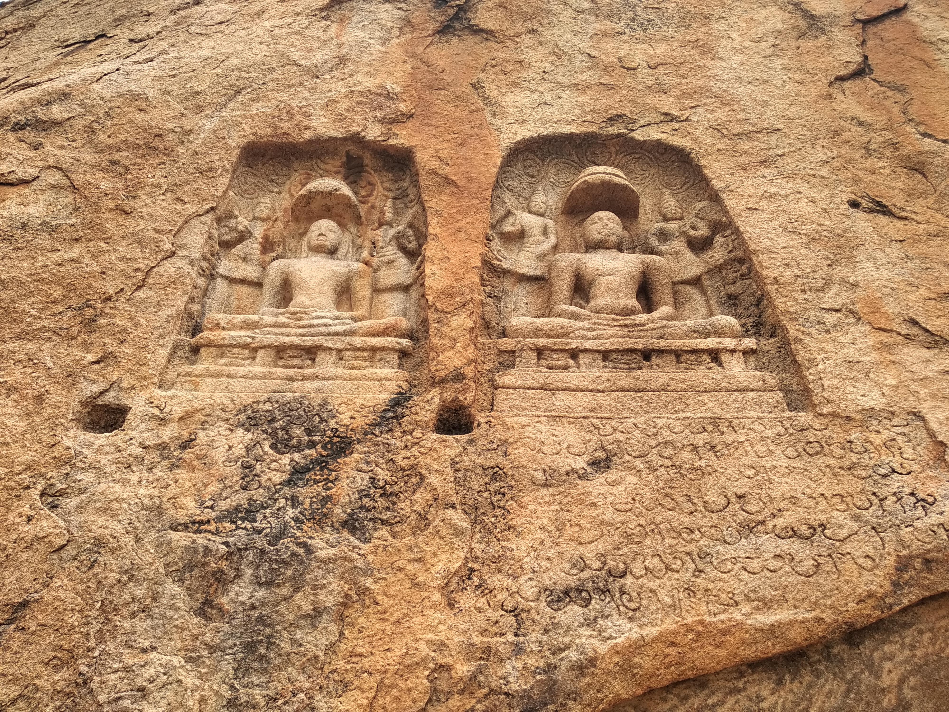
English: Rock Cut Bas Relief And Beds And A Mutilated Jain Stone Image
Below the statue one can read VATTA EZHUTTHU Vattezhuthu is the most ancient script. Devoid of consonants, this script is transformed from Brahmi Script, the most ancient script of India. A. R. Raja Raja Varma, in his famous work ‘Kerala Paanineeyam’, mentions that “Vattezhuthu” was the script used in Malayalam till the time of Thunchath Ezhuthachan. He details that the Vattezhuthu script was suitable to write Tamil but did not have consonants needed to transcribe Sanskrit words. During the ancient times, the official language as well as the trade language in Kerala was Tamil and hence the Vattezhuthu script was widely used. The Vattezhuthu script system was also known as ‘Naanam Monam’. The name came from the eight syllable manthra ‘Om Namo Narayana’ which was used to start the royal charters. The Vattezhuthu script was widely used from 8th century AD to 15th century AD. According to the linguist L. A. Ravi Varma, the original name of this script was ‘Vettezhuthu’ from the Malayalam word “Vettu” meaning cut as the letters were written by cutting into rocks or copper sheets using tools like the chisel.தமிழ்: YOU CAN READ THE VATTA EZHUTTHU BELOW THE STAUE AFTER ENLARGING IT
வட்டெழுத்து என்பது கி.பி மூன்றாம் நூற்றாண்டிலிருத்து கி.பி பத்தாம் நூற்றாண்டு வரை தமிழை எழுத பயன்படுத்தப்பட்டு வந்த ஓர் எழுத்து முறையாகும். வட்டெழுத்தை மலையாள மொழியினை எழுதவும் பயன்படுத்தினர். [1]தற்கால தமிழ் எழுத்துக்கள் தமிழி எழுத்திலிருந்து தோன்றியவையே. வட்டெழுத்தை வட்டெழுத்தை வட்டம் என குறிப்பிட்டுள்ளனர்.
|
||
| Date | |||
| Source | Own work | ||
| Author | Ponrajcomputer |
| Camera location | | View this and other nearby images on: OpenStreetMap |
|---|
Licensing[edit]
- You are free:
- to share – to copy, distribute and transmit the work
- to remix – to adapt the work
- Under the following conditions:
- attribution – You must give appropriate credit, provide a link to the license, and indicate if changes were made. You may do so in any reasonable manner, but not in any way that suggests the licensor endorses you or your use.
- share alike – If you remix, transform, or build upon the material, you must distribute your contributions under the same or compatible license as the original.

|
This image was uploaded as part of Wiki Loves Monuments 2019.
|
 |
File history
Click on a date/time to view the file as it appeared at that time.
| Date/Time | Thumbnail | Dimensions | User | Comment | |
|---|---|---|---|---|---|
| current | 07:32, 18 September 2019 | | 4,000 × 3,000 (6.64 MB) | Ponrajcomputer (talk | contribs) | User created page with UploadWizard |
You cannot overwrite this file.
File usage on Commons
There are no pages that use this file.