File:United States 1845-03-1845-12-de.png

Original file (1,000 × 677 pixels, file size: 215 KB, MIME type: image/png)
Captions
Captions
Summary[edit]
| Description |
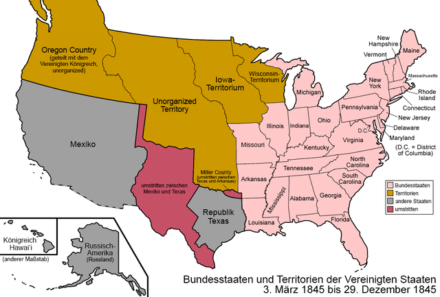
Deutsch: Karte der Bundesstaaten und Territorien der Vereinigten Staaten von März 1845 bis Dezember 1845. Am 3. März 1845 wurde das Florida-Territorium zum Bundesstaat erhoben. Am 29. Dezember 1845 wurden die Republik Texas und alle von ihr beanspruchten Gebiete in den Bundesstaat Texas umgewandelt. Deutsche Version.
English: Map of the states and territories of the United States as it was from March 1845 to December 1845. On March 3 1845, Florida Territory was admitted as the state of Florida. On December 29 1845, the Republic of Texas and all of its claimed lands were admitted as the state of Texas. |
| Date | |
| Source | Own work based on: United States 1845-03-1845-12.png by Golbez |
| Author | NordNordWest |
| Other versions |
|


|
This map has been made or improved in the German Kartenwerkstatt (Map Lab). You can propose maps to improve as well.
|
Licensing[edit]
Usage of this file with:

explanatory notes: Legally binding is only the full legalcode. For a free usage I recommend to respect the following licence conditions:
1. Provide my name as given above: NordNordWest,
2. a copy of, or the URI for, the applicable license: https://creativecommons.org/licenses/by-sa/3.0/de/legalcode,
3. the title of the work,
4. in the case of an adaptation, a credit identifying the use of the work in the adaptation.
This license and the rights granted hereunder will terminate automatically upon any breach by you of the terms of this license. Any of the above conditions can be waived if you get permission from the copyright holder. If you have questions or wish differing conditions, please contact me through nnwest or my discussion page ![]() t-online.de
t-online.de
- You are free:
- to share – to copy, distribute and transmit the work
- to remix – to adapt the work
- Under the following conditions:
- attribution – You must give appropriate credit, provide a link to the license, and indicate if changes were made. You may do so in any reasonable manner, but not in any way that suggests the licensor endorses you or your use.
- share alike – If you remix, transform, or build upon the material, you must distribute your contributions under the same or compatible license as the original.

File history
Click on a date/time to view the file as it appeared at that time.
| Date/Time | Thumbnail | Dimensions | User | Comment | |
|---|---|---|---|---|---|
| current | 19:44, 31 July 2019 | | 1,000 × 677 (215 KB) | NordNordWest (talk | contribs) | corr |
| 19:29, 31 July 2019 |  | 1,000 × 677 (215 KB) | NordNordWest (talk | contribs) | {{Information |Description= {{de|1=Karte der Bundesstaaten und Territorien der Vereinigten Staaten von März 1845 bis Dezember 1845. Am 3. März 1845 wurde das Florida-Territorium zum Bundesstaat erhoben. Am 29. Dezember 1845 wurden die Republik Texas und alle von ihr beanspruchten Gebiete in den Bundesstaat Texas umgewandelt. Deutsche Version.}} {{en|1=Map of the states and territories of the United States as it was from March 1845 to December 1845. On March 3 1845, Florida Territory was admit... |
You cannot overwrite this file.
File usage on Commons
The following 3 pages use this file:
File usage on other wikis
The following other wikis use this file:
- Usage on de.wikipedia.org