File:United Kingdom EU referendum 2016 area results.svg
Jump to navigation
Jump to search

Size of this PNG preview of this SVG file: 405 × 599 pixels. Other resolutions: 162 × 240 pixels | 324 × 480 pixels | 519 × 768 pixels | 692 × 1,024 pixels | 1,384 × 2,048 pixels | 871 × 1,289 pixels.
Original file (SVG file, nominally 871 × 1,289 pixels, file size: 4.84 MB)
Captions
Captions
Add a one-line explanation of what this file represents
Summary[edit]
| Description |
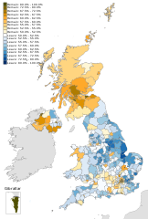
English: Map of the United Kingdom showing the voting areas for the European Union membership referendum, 2016. Areas marked in blue show a majority of votes in favour of leaving the European Union, while areas marked in yellow show a majority in favour of remaining a member. Русский: Результаты голосования на референдуме о членстве Великобритании в Европейском союзе по регионам Великобритании. |
| Date | |
| Source |
This vector image includes elements that have been taken or adapted from this file: This vector image includes elements that have been taken or adapted from this file: This vector image includes elements that have been taken or adapted from this file: This vector image includes elements that have been taken or adapted from this file: This vector image includes elements that have been taken or adapted from this file: |
| Author |
Mirrorme22 Brythones Nilfanion: English and Scottish council areas TUBS: Welsh council areas Sting: Gibraltar |
| Other versions |
|
| SVG development |


Licensing[edit]
This file is licensed under the Creative Commons Attribution-Share Alike 3.0 Unported license.
- You are free:
- to share – to copy, distribute and transmit the work
- to remix – to adapt the work
- Under the following conditions:
- attribution – You must give appropriate credit, provide a link to the license, and indicate if changes were made. You may do so in any reasonable manner, but not in any way that suggests the licensor endorses you or your use.
- share alike – If you remix, transform, or build upon the material, you must distribute your contributions under the same or compatible license as the original.
File history
Click on a date/time to view the file as it appeared at that time.
| Date/Time | Thumbnail | Dimensions | User | Comment | |
|---|---|---|---|---|---|
| current | 23:55, 26 May 2019 | | 871 × 1,289 (4.84 MB) | Renamed user OCfxJKu7j2 (talk | contribs) | Wrong map haah! |
| 23:49, 26 May 2019 |  | 871 × 1,289 (3.22 MB) | Renamed user OCfxJKu7j2 (talk | contribs) | update | |
| 11:20, 1 July 2016 |  | 871 × 1,289 (4.84 MB) | Renamed user OCfxJKu7j2 (talk | contribs) | better scale? | |
| 18:35, 27 June 2016 |  | 871 × 1,289 (4.84 MB) | Renamed user OCfxJKu7j2 (talk | contribs) | Text fixes | |
| 18:28, 27 June 2016 |  | 871 × 1,289 (4.84 MB) | Renamed user OCfxJKu7j2 (talk | contribs) | Better colour saturation | |
| 17:34, 27 June 2016 |  | 871 × 1,289 (4.84 MB) | Renamed user OCfxJKu7j2 (talk | contribs) | Minor changes | |
| 17:02, 27 June 2016 |  | 871 × 1,289 (4.84 MB) | Renamed user OCfxJKu7j2 (talk | contribs) | Changed text on scale from bold to normal. | |
| 16:55, 27 June 2016 |  | 871 × 1,289 (4.84 MB) | Renamed user OCfxJKu7j2 (talk | contribs) | Better colours and enlarged Gibraltar. | |
| 23:59, 24 June 2016 |  | 871 × 1,289 (5.04 MB) | Renamed user OCfxJKu7j2 (talk | contribs) | Saturation fix for Craven | |
| 08:47, 24 June 2016 |  | 871 × 1,289 (5.04 MB) | Lukasb1992 (talk | contribs) | more declarations |
You cannot overwrite this file.
File usage on Commons
The following 17 pages use this file:
- User:Kolja21
- User:Magog the Ogre/Political maps/2016 February
- User:Magog the Ogre/Political maps/2016 July 1-10
- User:Magog the Ogre/Political maps/2016 June 11-20
- User:Magog the Ogre/Political maps/2016 June 21-30
- User:Magog the Ogre/Political maps/2019 May 21-31
- File:Thai referendum 2016.svg
- File:UK MPs EU referendum voting intention 2016.svg
- File:United Kingdom EU referendum 2016 area results-de.svg
- File:United Kingdom EU referendum 2016 area results.svg
- File:United Kingdom EU referendum 2016 area results (3).svg
- File:United Kingdom EU referendum 2016 area results 2-tone.svg
- File:United Kingdom EU referendum 2016 area results 2.svg
- File:United Kingdom EU referendum 2016 area results BrB.svg
- File:United Kingdom EU referendum 2016 voting regions results.svg
- File:United Kingdom European Communities membership referendum, 1975 compared to United Kingdom European Union membership referendum, 2016.svg
- Category:2016 United Kingdom European Union membership referendum
.svg)
File usage on other wikis
The following other wikis use this file:
- Usage on als.wikipedia.org
- Usage on ar.wikipedia.org
- Usage on ast.wikipedia.org
- Usage on be.wikipedia.org
- Usage on bg.wikipedia.org
- Usage on bh.wikipedia.org
- Usage on bs.wikipedia.org
- Usage on ca.wikinews.org
- Usage on cs.wikipedia.org
- Usage on cy.wikipedia.org
- Usage on da.wikipedia.org
- Usage on de.wikipedia.org
- Usage on en.wikipedia.org
- User:Mirrorme22
- Template:Infobox referendum/testcases
- Talk:2016 United Kingdom European Union membership referendum/Archive 1
- Talk:2016 United Kingdom European Union membership referendum/Archive 2
- Proposed second Scottish independence referendum
- Wikipedia:Top 25 Report/June 19 to 25, 2016
- Wikipedia:Wikipedia Signpost/2016-07-04/Traffic report
- Wikipedia:Wikipedia Signpost/Single/2016-07-04
- User:Fako85/feed/possibly biased
- Wikipedia:Top 25 Report/2016
- User:Nallerton/sandbox
- Usage on es.wikipedia.org
- Usage on es.wikinews.org
- Usage on fa.wikipedia.org
- Usage on fo.wikipedia.org
- Usage on fr.wikipedia.org
- Usage on ga.wikipedia.org
- Usage on gd.wikipedia.org
- Usage on he.wikipedia.org
- Usage on hi.wikipedia.org
- Usage on hu.wikipedia.org
- Usage on hy.wikipedia.org
- Usage on it.wikipedia.org
- Usage on it.wikiversity.org
- Usage on ja.wikipedia.org
- Usage on ko.wikipedia.org
- Usage on la.wikipedia.org
View more global usage of this file.