File:Ungava magmatic event.png
Jump to navigation
Jump to search
No higher resolution available.
Ungava_magmatic_event.png (346 × 547 pixels, file size: 22 KB, MIME type: image/png)
Captions
Captions
Add a one-line explanation of what this file represents
Summary[edit]
| Description |
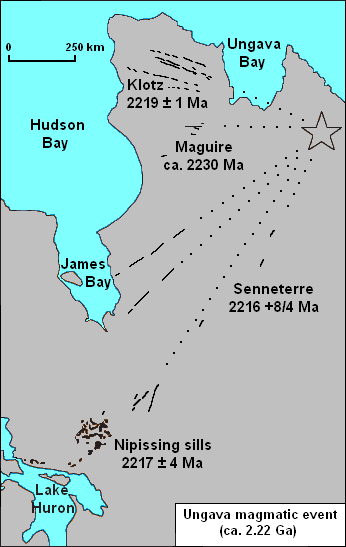
English: Map of the Ungava magmatic event in Eastern Canada. |
| Date | |
| Source | Own work based on map found on http://gsc.nrcan.gc.ca/mindep/synth_prov/lip/index_e.php |
| Author | Black Tusk |
| Other versions | Derivative works of this file: Ungava magmatic event He.jpg |
Licensing[edit]
| I, the copyright holder of this work, release this work into the public domain. This applies worldwide. In some countries this may not be legally possible; if so: I grant anyone the right to use this work for any purpose, without any conditions, unless such conditions are required by law. |
File history
Click on a date/time to view the file as it appeared at that time.
| Date/Time | Thumbnail | Dimensions | User | Comment | |
|---|---|---|---|---|---|
| current | 19:47, 17 May 2010 | | 346 × 547 (22 KB) | Black Tusk (talk | contribs) | {{Information |Description={{en|1=Map of the Ungava magmatic event in Eastern Canada.}} |Source={{own}} based on map found on [http://gsc.nrcan.gc.ca/mindep/synth_prov/lip/index_e.php http://gsc.nrcan.gc.ca/mindep/synth_prov/lip/index_e.php] |Author=[[Use |
You cannot overwrite this file.
File usage on Commons
The following page uses this file:
File usage on other wikis
The following other wikis use this file:
- Usage on en.wikipedia.org
- Usage on he.wikipedia.org
- Usage on www.wikidata.org