File:US Navy 050708-N-2903M-001 Waves crash against the southern coastline of Naval Station Guantanamo Bay, Cuba, just east of the base lighthouse.jpg
Jump to navigation
Jump to search

Size of this preview: 428 × 599 pixels. Other resolutions: 171 × 240 pixels | 343 × 480 pixels | 548 × 768 pixels | 731 × 1,024 pixels | 1,500 × 2,100 pixels.
Original file (1,500 × 2,100 pixels, file size: 2.2 MB, MIME type: image/jpeg)
Captions
Captions
Add a one-line explanation of what this file represents
Summary[edit]
| Description |
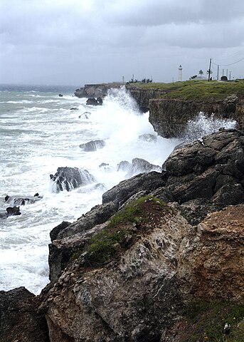
English: Guantanamo Bay, Cuba (July 8, 2005) - Waves crash against the southern coastline of Naval Station Guantanamo Bay, Cuba, just east of the base lighthouse. Hurricane Dennis passed the station, between 1 and 2 p.m. Thursday, July 7, sustained winds were recorded at 35 knots, gusting to 47. At that point, the eye of the storm was 87 nautical miles southwest of the station. Seas at the mouth of the bay were cresting at 10 feet, and were 12-14 feet offshore. The base suffered minimal damage and there were no injuries. U.S. Navy photo by Photographer’s Mate 1st Class Terry Matlock (RELEASED) |
|||
| Date | Taken on 8 July 2005 | |||
| Source |
|
|||
| Author | U.S. Navy photo by Photographer’s Mate 1st Class Terry Matlock |

Licensing[edit]
This file is a work of a sailor or employee of the U.S. Navy, taken or made as part of that person's official duties. As a work of the U.S. federal government, it is in the public domain in the United States.
|
 | |
| This file has been identified as being free of known restrictions under copyright law, including all related and neighboring rights. | ||
File history
Click on a date/time to view the file as it appeared at that time.
| Date/Time | Thumbnail | Dimensions | User | Comment | |
|---|---|---|---|---|---|
| current | 03:22, 23 October 2009 | | 1,500 × 2,100 (2.2 MB) | BotMultichillT (talk | contribs) | == {{int:filedesc}} == {{Information |description={{en|1=Guantanamo Bay, Cuba (July 8, 2005) - Waves crash against the southern coastline of Naval Station Guantanamo Bay, Cuba, just east of the base lighthouse. Hurricane Dennis passed the station, between |
You cannot overwrite this file.
File usage on Commons
The following 2 pages use this file:
File usage on other wikis
The following other wikis use this file:
- Usage on en.wikipedia.org