File:U-Netz Frankfurt.svg
Jump to navigation
Jump to search

Size of this PNG preview of this SVG file: 497 × 599 pixels. Other resolutions: 199 × 240 pixels | 398 × 480 pixels | 637 × 768 pixels | 849 × 1,024 pixels | 1,698 × 2,048 pixels | 1,765 × 2,129 pixels.
Original file (SVG file, nominally 1,765 × 2,129 pixels, file size: 289 KB)
Captions
Captions
Add a one-line explanation of what this file represents
Summary[edit]
| Description |
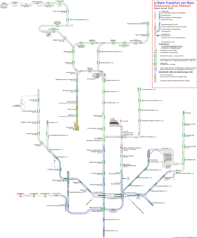
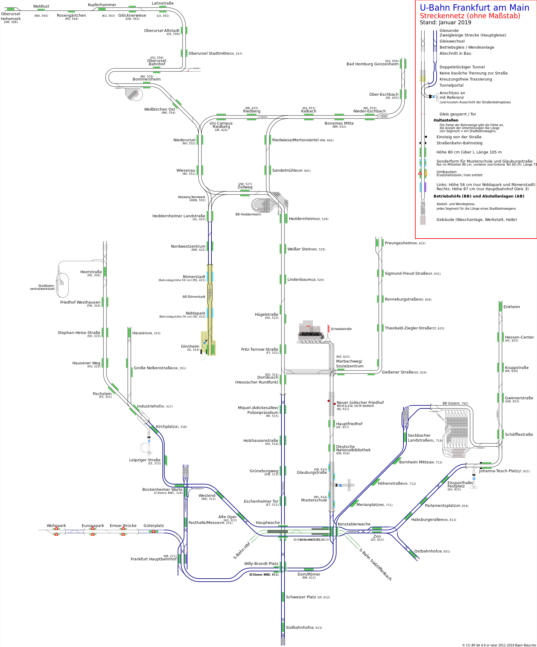
English: Track layout of Frankfurt U-Bahn.
Deutsch: Streckennetz der U-Bahn Frankfurt am Main. |
| Date | |
| Source |
Own work Deutsch: Eine umfassendere, interaktive Version mit den Streckenkilometrierungen ist unter http://plan.frankfurtium.de/ubahnnetz.svg English: A more extensive, interactive Version with the tracks' mileage is available at http://plan.frankfurtium.de/ubahnnetz.svg |
| Author | Baeuchle |
| Other versions | U-Netz Frankfurt.png |
Licensing[edit]
I, the copyright holder of this work, hereby publish it under the following licenses:

|
Permission is granted to copy, distribute and/or modify this document under the terms of the GNU Free Documentation License, Version 1.2 or any later version published by the Free Software Foundation; with no Invariant Sections, no Front-Cover Texts, and no Back-Cover Texts. A copy of the license is included in the section entitled GNU Free Documentation License. |
This file is licensed under the Creative Commons Attribution 4.0 International license.
- You are free:
- to share – to copy, distribute and transmit the work
- to remix – to adapt the work
- Under the following conditions:
- attribution – You must give appropriate credit, provide a link to the license, and indicate if changes were made. You may do so in any reasonable manner, but not in any way that suggests the licensor endorses you or your use.
You may select the license of your choice.
File history
Click on a date/time to view the file as it appeared at that time.
| Date/Time | Thumbnail | Dimensions | User | Comment | |
|---|---|---|---|---|---|
| current | 09:49, 6 January 2019 | | 1,765 × 2,129 (289 KB) | Baeuchle (talk | contribs) | SVG-errors corrected |
| 20:18, 17 December 2018 |  | 1,765 × 2,129 (289 KB) | Baeuchle (talk | contribs) | Ausführliche Legende und korrekter Permalink | |
| 20:16, 17 December 2018 |  | 1,765 × 2,129 (289 KB) | Baeuchle (talk | contribs) | Neue, ausführliche Legende | |
| 20:14, 30 October 2016 |  | 1,765 × 2,129 (127 KB) | Baeuchle (talk | contribs) | Umbau der Stationen an der Eckenheimer Landstraße abgeschlossen. | |
| 11:00, 27 March 2016 |  | 1,765 × 2,129 (127 KB) | Baeuchle (talk | contribs) | Korrekte Version mit Umbau Eckenheimer Landstraße | |
| 10:55, 27 March 2016 |  | 1,765 × 2,129 (127 KB) | Baeuchle (talk | contribs) | Korrekte Version mit Umbau Eckenheimer Landstraße. (Vorherige Version war mit Preungesheim fertig, ohne Eckenheimer Landstraße) | |
| 10:52, 27 March 2016 |  | 1,765 × 2,129 (126 KB) | Baeuchle (talk | contribs) | Preugesheim Umbau abgeschlossen; Umbau und Sperrung untere Eckenheimer Landstraße. | |
| 19:28, 4 July 2015 |  | 1,765 × 2,136 (124 KB) | Baeuchle (talk | contribs) | Barrierefreier Bahnsteig in Ginnheim; Bauarbeiten in Preungesheim. | |
| 08:54, 2 April 2015 |  | 1,765 × 2,136 (123 KB) | Baeuchle (talk | contribs) | Leicht verändertes Layout, Linie U4 nun komplett mit 80-cm-Bahnsteigen | |
| 20:32, 19 December 2014 |  | 1,765 × 2,217 (117 KB) | Baeuchle (talk | contribs) | Bauarbeiten entlang der U5 |
You cannot overwrite this file.
File usage on Commons
The following 25 pages use this file:
- U-Bahn Frankfurt
- User:Chumwa/OgreBot/Potential transport maps/2016 March 21-31
- User:Chumwa/OgreBot/Potential transport maps/2016 October 21-31
- User:Chumwa/OgreBot/Potential transport maps/2018 December 11-20
- User:Chumwa/OgreBot/Potential transport maps/2019 January 1-10
- User:Chumwa/OgreBot/Public transport information/2015 April 1-10
- User:Chumwa/OgreBot/Public transport information/2015 July 1-10
- User:Chumwa/OgreBot/Public transport information/2016 March 21-31
- User:Chumwa/OgreBot/Public transport information/2016 October 21-31
- User:Chumwa/OgreBot/Public transport information/2018 December 11-20
- User:Chumwa/OgreBot/Public transport information/2019 January 1-10
- User:Chumwa/OgreBot/Transport Maps/2015 April 1-10
- User:Chumwa/OgreBot/Transport Maps/2015 July 1-10
- User:Chumwa/OgreBot/Transport Maps/2016 March 21-31
- User:Chumwa/OgreBot/Transport Maps/2016 October 21-31
- User:Chumwa/OgreBot/Transport Maps/2018 December 11-20
- User:Chumwa/OgreBot/Transport Maps/2019 January 1-10
- User:Chumwa/OgreBot/Travel and communication maps/2016 March 21-31
- User:Chumwa/OgreBot/Travel and communication maps/2016 October 21-31
- User:Chumwa/OgreBot/Travel and communication maps/2018 December 11-20
- User:Chumwa/OgreBot/Travel and communication maps/2019 January 1-10
- User:Nordlicht8/Rail Germany/2015 April 1-10
- User:Nordlicht8/Rail Germany/2015 July 1-10
- User:Nordlicht8/Rail Germany/2016 March 21-31
- File:U-Netz Frankfurt.png
File usage on other wikis
The following other wikis use this file:
- Usage on de.wikipedia.org
- Usage on pl.wikipedia.org
- Usage on pl.wikivoyage.org
- Usage on www.wikidata.org