File:Trophic state of water in the Danube Delta.jpg
From Wikimedia Commons, the free media repository
Jump to navigation
Jump to search

Size of this preview: 421 × 599 pixels. Other resolutions: 168 × 240 pixels | 337 × 480 pixels | 539 × 768 pixels | 719 × 1,024 pixels | 1,438 × 2,048 pixels | 5,669 × 8,071 pixels.
Original file (5,669 × 8,071 pixels, file size: 6.13 MB, MIME type: image/jpeg)
File information
Structured data
Captions
Captions
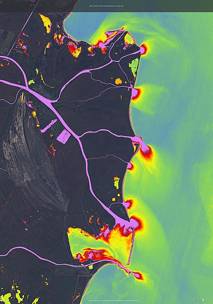
The map of the trophic state of water in the Danube Delta
Summary[edit]
| DescriptionTrophic state of water in the Danube Delta.jpg |
Українська: Карта трофічного стану води в районі дельти Дунаю отримана 8 листопада 2020 року на основі скриптуSe2WaQ реалізованому в EO-browser. Градієнтне зображення трофності створено з веб-інструменту з відкритим кодом для перегляду, візуалізації та аналізу супутникових зображень EO-browser створеного в рамках проекту Copernicus. Сценарій Se2WaQ - Sentinel-2 Water Quality розроблений N S A Pereira - використовує знімки Sentinel-2 (L1C та L2A) для визначення трофічного стану водойм на основі шести відповідних показників якості води: концентрація хлорофілу a, щільність ціанобактерій, каламутності, забарвлена розчинена органічна речовина, розчинений органічний вуглець і колір води. На карті видно, що вода яку виносить річка Дельта при впадінні в Чорне море дуже відрізняється за своїм трофічним станом, що може бути пов’язано з відповідним антропогенним впливом. English: The map of the trophic state of water in the Danube Delta region was obtained on November 8, 2020 on the basis of the Se2WaQ script implemented in the EO-browser. The trophy gradient image is created from an open source web tool for viewing, visualizing and analyzing satellite images of the EO-browser created within the Copernicus project. The Se2WaQ scenario - Sentinel-2 Water Quality developed by NSA Pereira - uses Sentinel-2 products (L1C and L2A) to determine the trophic status of water bodies based on six relevant indicators of water quality: the concentration of Chlorophyll a, the density of cyanobacteria, turbidity, colored dissolved organic matter, dissolved organic carbon and water color. The map shows that the water carried by the Delta River at the confluence with the Black Sea is very different in its trophic state, which may be due to the corresponding anthropogenic impact. |
| Date | |
| Source | Own work |
| Author | Tomchenko Olha |
| Camera location | 45° 22′ 03″ N, 29° 49′ 51.41″ E | View this and other nearby images on: OpenStreetMap |
|---|
Licensing[edit]
I, the copyright holder of this work, hereby publish it under the following license:
This file is licensed under the Creative Commons Attribution 4.0 International license.
- You are free:
- to share – to copy, distribute and transmit the work
- to remix – to adapt the work
- Under the following conditions:
- attribution – You must give appropriate credit, provide a link to the license, and indicate if changes were made. You may do so in any reasonable manner, but not in any way that suggests the licensor endorses you or your use.
| This image was uploaded as part of Science Photo Competition 2021 in Ukraine. |
File history
Click on a date/time to view the file as it appeared at that time.
| Date/Time | Thumbnail | Dimensions | User | Comment | |
|---|---|---|---|---|---|
| current | 21:32, 15 December 2021 |  | 5,669 × 8,071 (6.13 MB) | Tomch olha (talk | contribs) | Uploaded own work with UploadWizard |
You cannot overwrite this file.
File usage on Commons
The following 2 pages use this file:
Metadata
This file contains additional information such as Exif metadata which may have been added by the digital camera, scanner, or software program used to create or digitize it. If the file has been modified from its original state, some details such as the timestamp may not fully reflect those of the original file. The timestamp is only as accurate as the clock in the camera, and it may be completely wrong.
| Orientation | Normal |
|---|---|
| Horizontal resolution | 72 dpi |
| Vertical resolution | 72 dpi |
| Software used | Adobe Photoshop 21.1 (Windows) |
| File change date and time | 23:05, 15 December 2021 |
| Color space | Uncalibrated |
| Date and time of digitizing | 00:58, 16 December 2021 |
| Date metadata was last modified | 01:05, 16 December 2021 |
| Unique ID of original document | xmp.did:119c126d-68de-b040-97ca-d4fac6b5b906 |
Structured data
Items portrayed in this file
depicts
some value
16 December 2021
45°22'3.0"N, 29°49'51.2"E
image/jpeg
Hidden categories:
- Non-photographic media from Wiki Science Competition in Ukraine 2021
- Files with coordinates missing SDC location of creation
- CC-BY-4.0
- Self-published work
- Images from Wiki Science Competition 2021 in Ukraine
- Uploaded via Campaign:espc-ua
- National finalists for the Non-photographic media category from Wiki Science Competition 2021
- Pages with maps
