File:Traversée de la Place de l'Étoile. Plan général.jpg
Jump to navigation
Jump to search

Size of this preview: 615 × 599 pixels. Other resolutions: 246 × 240 pixels | 493 × 480 pixels | 788 × 768 pixels | 1,051 × 1,024 pixels | 2,355 × 2,295 pixels.
Original file (2,355 × 2,295 pixels, file size: 1.1 MB, MIME type: image/jpeg)
Captions
Captions
Add a one-line explanation of what this file represents
Summary[edit]
| Description |
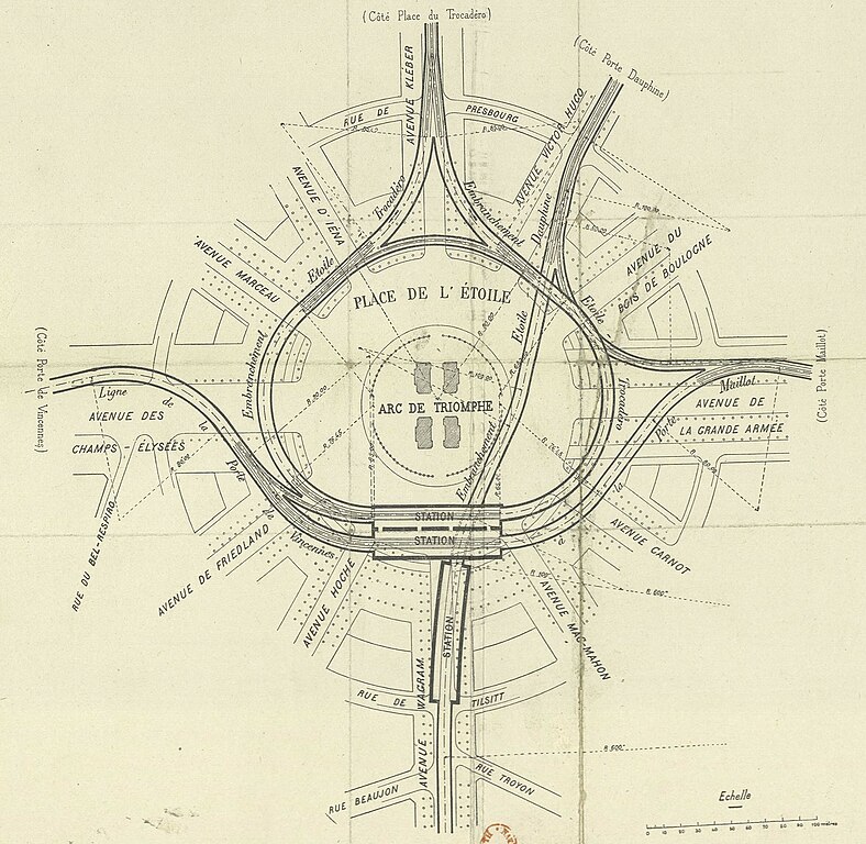
Deutsch: Karte der Metrotunnel unter dem Place d'Étoile in Paris. Nordrichtung nach unten. Im Süden (oben) in der Avenue Kléber die ehemalige Linie 2 Sud, heute Linie 6, die in einer Wendeschleife am Place d'Étoile endet. Von Ost nach West die Linie 1. Von oben rechts nach unten Mitte die ehemalige Linie 2 Nord, heute Linie 2, die unter den anderen Linien hindurch geht. Die Verbindung aus der Avenue de la Grande Armée in die Avenue Victor Hugo wurde in den 2000er Jahren verschlossen als die Linie 1 in den automatischen Betrieb ging, die restlichen Tunnel sind immer noch in Betrieb. |
| Date | |
| Source | Jules Hervieu:Le chemin de fer métropolitain municipal de Paris. 1903, C. Béranger, Paris. Planche III, Fig. 2. |
| Author | Unknown author |
Licensing[edit]
|
This work is in the public domain in its country of origin and other countries and areas where the copyright term is the author's life plus 70 years or fewer. This work is in the public domain in the United States because it was published (or registered with the U.S. Copyright Office) before January 1, 1929. | |
| This file has been identified as being free of known restrictions under copyright law, including all related and neighboring rights. | |
File history
Click on a date/time to view the file as it appeared at that time.
| Date/Time | Thumbnail | Dimensions | User | Comment | |
|---|---|---|---|---|---|
| current | 03:10, 3 November 2023 | | 2,355 × 2,295 (1.1 MB) | Pechristener (talk | contribs) | Uploaded a work by {{Unknown|author}} from Jules Hervieu:''Le chemin de fer métropolitain municipal de Paris''. 1903, C. Béranger, Paris. Planche III, [https://gallica.bnf.fr/ark:/12148/bpt6k133122g/f44.item Fig. 2.] with UploadWizard |
You cannot overwrite this file.
File usage on Commons
The following 2 pages use this file:
File usage on other wikis
The following other wikis use this file:
- Usage on de.wikipedia.org
- Usage on fr.wikipedia.org