File:Tornado Track near Sturbridge, Massachusetts.jpg

Original file (2,000 × 775 pixels, file size: 1.65 MB, MIME type: image/jpeg)
Captions
Captions
Summary[edit]
| DescriptionTornado Track near Sturbridge, Massachusetts.jpg |
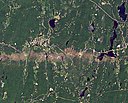
English: On June 1, 2011, a supercell thunderstorm developed over western Massachusetts. The storm produced an EF3 tornado that cut a 39-mile (63-kilometer) track of destruction across southwest and south-central Massachusetts. Not only did the tornado remain on the ground for many miles, but it also widened to roughly 0.5 miles (0.8 kilometers) in Brimfield State Forest.
The Thematic Mapper on the Landsat 5 satellite captured this natural-color image on June 5, 2011, showing part of the tornado track including damage in Sturbridge. According to The Boston Globe, Massachusetts state police reported a tornado on the ground and cars overturned near Interstate 84 in Sturbridge at 5:22 p.m. on June 1. Massachusetts Governor Deval Patrick declared a state of emergency and ordered National Guard troops to assist with cleanup efforts. Tornadoes killed at least four residents, while reducing homes, schools, and churches to rubble. When the tornado first touched down in the Munger Hill section of Westfield, Massachusetts, damage was mostly limited to trees, the National Weather Service reported. The tornado quickly intensified, however, as it traveled to West Springfield. The Boston Globe reported that two deaths occurred in West Springfield, one death in Springfield, and another death in Brimfield. The number of people injured was unknown the day after the storm, but 33 people were known to have been injured in Springfield alone. Deadly tornadoes are unusual but not unheard of in Massachusetts. In 1953, one of the single deadliest tornadoes in U.S. history struck Worcester, killing 94 people. NASA Earth Observatory image created by Jesse Allen, using Landsat data provided by Julia Barsi of the Landsat Project Science Office. Caption by Michon Scott. Instrument: Landsat 5 - TM |
|||
| Date | ||||
| Source | https://www.flickr.com/photos/gsfc/5805753622/ | |||
| Author | NASA | |||
| Other versions |
|
Licensing[edit]
| Public domainPublic domainfalsefalse |
| This file is in the public domain in the United States because it was solely created by NASA. NASA copyright policy states that "NASA material is not protected by copyright unless noted". (See Template:PD-USGov, NASA copyright policy page or JPL Image Use Policy.) |  | |
 |
Warnings:
|
| This image was originally posted to Flickr by NASA Goddard Photo and Video at https://flickr.com/photos/24662369@N07/5805753622. It was reviewed on 2017-08-03 20:45:32 by FlickreviewR, who found it to be licensed under the terms of the cc-by-2.0, which is compatible with the Commons. It is, however, not the same license as given above, and it is unknown whether that license ever was valid. |
File history
Click on a date/time to view the file as it appeared at that time.
| Date/Time | Thumbnail | Dimensions | User | Comment | |
|---|---|---|---|---|---|
| current | 14:31, 22 July 2014 | 2,000 × 775 (1.65 MB) | Numéro 1963 (talk | contribs) | User created page with UploadWizard |
You cannot overwrite this file.
File usage on Commons
The following page uses this file:
Metadata
This file contains additional information such as Exif metadata which may have been added by the digital camera, scanner, or software program used to create or digitize it. If the file has been modified from its original state, some details such as the timestamp may not fully reflect those of the original file. The timestamp is only as accurate as the clock in the camera, and it may be completely wrong.
| Image title |
|
|---|---|
| Width | 7,771 px |
| Height | 7,051 px |
| Bits per component |
|
| Compression scheme | LZW |
| Pixel composition | RGB |
| Orientation | Normal |
| Number of components | 3 |
| Horizontal resolution | 100 dpi |
| Vertical resolution | 100 dpi |
| Data arrangement | chunky format |
| Software used | Adobe Photoshop CS5 Macintosh |
| File change date and time | 15:51, 6 June 2011 |
| Exif version | 2.21 |
| Color space | Uncalibrated |
| Date and time of digitizing | 07:39, 6 June 2011 |
| Date metadata was last modified | 11:51, 6 June 2011 |
| Unique ID of original document | xmp.did:02801174072068119109A3A6F752B84D |
