File:Topographical Map of Wisconsin Territory WDL6769.png
Jump to navigation
Jump to search

Size of this preview: 761 × 600 pixels. Other resolutions: 305 × 240 pixels | 609 × 480 pixels | 974 × 768 pixels | 1,280 × 1,009 pixels | 1,299 × 1,024 pixels.
Original file (1,299 × 1,024 pixels, file size: 2.08 MB, MIME type: image/png)
Captions
Captions
Add a one-line explanation of what this file represents
Summary[edit]
| Author |
Русский: Висконсин. Комиссия по общественным землям
Français : Wisconsin. Conseil des commissaires des terres publiques
English: Wisconsin. Board of Commissioners of Public Lands
中文:威斯康星州公共土地委员会 (Wisconsin. Board of Commissioners of Public Lands)
Português: Wisconsin. Conselho de Comissários de Terras Públicas
العربية: ويسكونسن مجلس مفوضي الأراضي العامة
Español: Wisconsin. Junta de comisionados de tierras públicas |
| Title |
Русский: Топографическая карта Территории Висконсин
Français : Carte topographique du territoire du Wisconsin
English: Topographical Map of Wisconsin Territory
中文:威斯康辛地区地形图
Português: Mapa Topográfico do Território de Wisconsin
العربية: الخريطة الطبوغرافية لمقاطعة ويسكونسن
Español: Mapa topográfico del territorio de Wisconsin |
| Description |
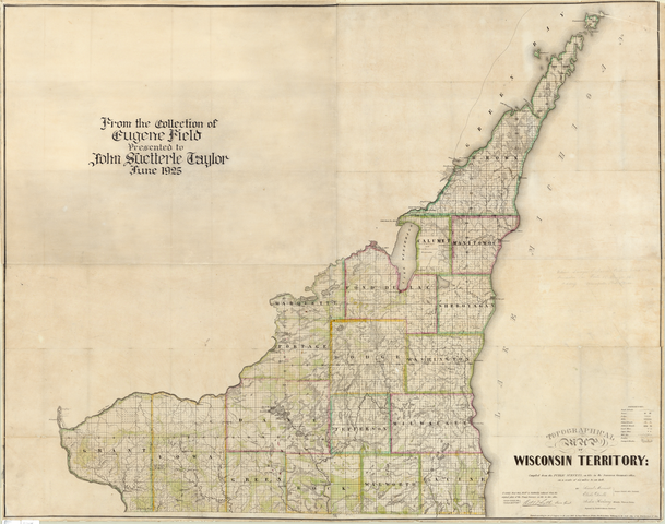
Русский: Это первая крупномасштабная карта Территории Висконсин, составленная на основе контурных съемок. Карту составили и опубликовали топографы Сэмюэл Моррисон, Элиша Двэлль и Джошуа Хатэуэй. Гравирование выполнено на трех медных печатных формах. В 1785 г. Конгресс Соединенных Штатов Америки принял постановление о межевании земли, в котором была предусмотрена система тауншипов, участков государственного межевания в виде квадратов со стороной шесть миль, поделенных на 36 участков площадью в одну кв. милю. На карте показаны тауншипы Территории Висконсин, размежеванные к 1837 г. На карте также обозначены дороги, тропы, естественные формы рельефа, растительность, места расположения мельниц, известные в то время месторождения свинца и меди. Длинные участки земли в Грин-Бей и Прейри-дю-Чиен отражают французскую систему землевладения, принятую вдоль берегов рек. Карты, аналогичные этой, помогали переселенцам и колонистам понять систему межевания и определить местоположение участка земли, который они покупали. Потенциальный покупатель мог пойти в любую государственную контору, регистрирующую земельные сделки, и посмотреть планы земельных участков с подробным описанием земли. Как следует из дарственной надписи, карта одно время принадлежала американскому писателю Юджину Филду (1850–1895 гг.).
Топографические карты Français : Il s'agit selon les études actuelles de la première carte à grande échelle du territoire de Wisconsin. La carte fut compilée et publiée par les géomètres Samuel Morrison, Elisha Dwelle et Joshua Hathaway et gravée sur trois plaques de cuivre. En 1785, le congrès des États-Unis adopta l'ordonnance sur l'aménagement du territoire qui stipulait un système d'aménagement des villes en carrés de six miles de côté, divisés en 36 sections d'un mile carré. La carte représente les villes du Territoire du Wisconsin élaborées en 1837. Les routes, les chemins de fer, les reliefs naturels, la végétation, les usines et les gisements de plomb et de cuivre connus à cette époque sont également représentés. Les longs domaines de Green Bay et de Prairie du Chien reflètent le système français d'aménagement du territoire le long des fleuves. Les cartes de cet acabit aidèrent les immigrants et les colons à comprendre le système d'aménagement et à localiser les terres qu'ils avaient achetées. Un acheteur potentiel pouvait aller dans n'importe quel bureau du cadastre du gouvernement des États-Unis et consulter le registre des parcelles contenant les descriptions détaillées du territoire. Comme l'indique l'inscription, la carte a appartenu auparavant à l'écrivain américain Eugene Field (1850-1895).
Cartes topographiques English: This is the first large-scale map of the Wisconsin Territory based on actual surveys. The map was compiled and published by the surveyors Samuel Morrison, Elisha Dwelle, and Joshua Hathaway and engraved on three copperplates. In 1785, the United States Congress passed the Land Survey Ordinance, which provided for a system of square townships six miles on a side, divided into 36 one-square-mile sections. The map shows townships in the Wisconsin Territory surveyed by 1837. Also depicted are roads, trails, natural land forms, vegetation, mill sites, and the lead and copper deposits known at the time. The long lots in Green Bay and Prairie du Chien reflect the French system of land holdings along riverfronts. Maps such as these helped immigrants and settlers understand the survey system and locate the land they bought. A prospective buyer could go to any U.S. Government Land Office and look in tract books that contained detailed descriptions of the land. As the inscription states, the map once belonged to the American writer Eugene Field (1850–95).
Topographic maps 中文:这是第一幅根据实测数据绘制的威斯康辛地区大幅地图。该地图由勘测师塞缪尔·莫里森 (Samuel Morrison)、以利沙·杜韦乐 (Elisha Dwelle) 和乔舒亚·哈瑟维 (Joshua Hathaway) 收集资料并出版,刻在三块铜版上。1785 年,美国国会通过《土地测量法令》(Land Survey Ordinance),推出正方形镇区制度,规定镇区边长为六英里,划分为 36 块土地,每块土地面积为一平方英里。该地图显示了威斯康辛地区在 1837 年之前测量的镇区,还绘出了街道、小路、天然地形、植被、工厂以及当时探明的铅、铜矿藏。格林湾和普雷里德欣的长条地块反映了沿河一带的法式土地持有制度。当时,这类地图帮助移民和定居者了解了测量制度并找到自己购买的土地。有意购买者可前往美国政府土地管理局,查阅包含土地情况详细描述的土地簿册。按照地图上的题词所述,该地图曾一度属于美国作家尤金·菲尔德 (Eugene Field)(1850–95 年)。
地形图 Português: Este é o primeiro mapa em grande escala do Território de Wisconsin com base em pesquisas reais. O mapa foi compilado e publicado pelos pesquisadores Samuel Morrison, Elisha Dwelle e Joshua Hathaway e gravado em três placas de cobre. Em 1785, o Congresso dos Estados Unidos aprovou a Portaria de Estudos Terrestres, que previa um sistema de municípios quadrados de seis milhas de lado, divididos em 36 seções de um quilômetro quadrado. O mapa apresenta municípios do Território de Wisconsin pesquisados em 1837. Também estão descritos estradas, trilhas, formas naturais da terra, vegetação, moinhos, e os depósitos de chumbo e cobre conhecidos na época. Os extensos lotes em Green Bay e Prairie du Chien refletem o sistema francês de posse de terra ao longo das margens dos rios. Mapas como estes ajudaram os imigrantes e colonizadores a compreender o sistema de levantamento, e a localizar as terras adquiridas. Um potencial comprador poderia se dirigir a qualquer Escritório de Registro da Terra do Governo dos EUA e consultar os trechos dos livros que continham descrições detalhadas da terra. Conforme aponta a inscrição, o mapa já pertenceu ao escritor norte-americano Eugene Field (1850-95).
Mapas topográficos العربية: هذه هي أول خريطة كبيرة الحجم لمقاطعة ويسكونسن بناء على عمليات مسح حقيقية. وقد جمع المساحون "صامويل موريسون" و"إليشا دويل" و"جوشوا هاثواي" الخريطة وقاموا بنشرها ونقشها على ثلاثة ألواح نحاسية. في عام 1785، مرر الكونجرس الأمريكي قانون مسح الأراضي، الذي أتَى بنظام البلدات المربعة بواقع ستة أميال على كل جانب، تقسم بعد ذلك إلى 36 قسمًا بواقع ميل واحد مربع. توضح الخريطة البلديات في مقاطعة ويسكونسن التي تم مسحها بحلول عام 1837. كما تصور الطرق والسكك وأشكال الأرض الطبيعية والمناطق النباتية ومواقع المطاحن ورواسب الرصاص والنحاس المعروفة في ذلك الوقت. تعكس الأقسام الطويلة في الخليج الأخضر ومرج دو شين النظام الفرنسي في امتلاك الأراضي على طول ضفاف النهر. وقد ساعدت مقل هذه الخرائط المهاجرين والمستوطنين على فهم نظام المسح وتحديد الأراضي التي يقومون بشرائها. ومن الممكن لأي مشتري محتمل الذهاب إلى أي مكتب أراضي تابع لحكومة الولايات المتحدة والبحث في دفاتر قطع الأراضي التي تضم أوصافًا تفصيلية للأرض. وكما جاء في النقش، ترجع ملكية الخريطة في وقت ما إلى الكاتب الأمريكي "يوجين فيلد" (1850-1895).
الخرائط الطبوغرافية Español: Este es el primer mapa a gran escala del territorio de Wisconsin confeccionado a partir de inspecciones reales. El mapa fue compilado y publicado por los topógrafos Samuel Morrison, Elisha Dwelle y Joshua Hathaway y se grabó en tres placas de cobre. En 1785, el Congreso de los Estados Unidos aprobó la Ordenanza de catastro, que preveía un sistema de municipios cuadrados de seis millas por lado, divididos en 36 secciones de una milla cuadrada. El mapa muestra los municipios en el territorio de Wisconsin que se habían reconocido para 1837. También están representados los caminos, los senderos, los accidentes geográficos naturales, la vegetación, los molinos y los depósitos de plomo y cobre que se conocían en esa época. Los lotes largos en Green Bay y Prairie du Chien reflejan el sistema francés de posesión de tierras a orillas de los ríos. Los mapas como éstos ayudaban a los inmigrantes y pobladores a comprender el sistema de agrimensura y a ubicar la tierra que habían comprado. Un comprador potencial podía ir a cualquier Oficina de Catastro del gobierno de los EE. UU. y fijarse en los registros que contenían descripciones detalladas de las tierras. Como informa la inscripción, el mapa perteneció al escritor estadounidense Eugene Field (1850–1895).
Mapas topográficos |
| Date | 1837 |
| Medium |
Русский: Карты
Français : Cartes
English: Maps
中文:地图
Português: Mapas
العربية: خرائط
Español: Mapas |
| Dimensions |
English: 1 map : color ; 113 x 90 centimeters |
| Collection |
Русский: Библиотеки университета Висконсин–Милуоки
Français : Bibliothèques de l’Université du Wisconsin-Milwaukee
English: University of Wisconsin-Milwaukee Libraries
中文:威斯康星大学密尔沃基分校图书馆
Português: Bibliotecas da Universidade de Wisconsin-Milwaukee
العربية: مكتبات جامعة وِسْكَنْسِنْ بِمِلْوَوْكِى
Español: Bibliotecas de la Universidad de Wisconsin - Milwaukee |
| Current location |
Русский: Цифровая коллекция карт библиотеки Американского географического общества
Français : Collection de cartes numériques de la bibliothèque de l'American Geographical Society
English: American Geographical Society Library Digital Map Collection
中文:美国地理学会图书馆数字地图集
Português: Coleção de Mapas Digitais da Biblioteca da Sociedade Geográfica Americana
العربية: مجموعة الخرائط الرقمية لمكتبة الجمعية الجغرافية الأمريكية
Español: Colección de mapas digitales de la Biblioteca de la Sociedad Geográfica Estadounidense |
| Place of creation |
Русский: Висконсин
Français : Wisconsin
English: Wisconsin
中文:威斯康星州
Português: Wisconsin
العربية: ويسكونسن
Español: Wisconsin |
| Notes |
Русский: Масштаб 1:200 000. Изображение рельефа штрихами.
Français : Échelle 1:200 000. Relief représenté par des hachures.
English: Scale 1:200,000. Relief shown by hachures.
中文:比例尺:1:200,000。地势由晕翁线示出。
Português: Escala de 1:200.000. Relevo mostrado por hachuras.
العربية: مقياس الرسم 1:200،000.التضاريس موضحة باستخدام برنامج الخطوط المتوازية.
Español: Escala 1:200 000. Se muestra el relieve por sombreado. |
| References | http://hdl.loc.gov/loc.wdl/wmuw.6769 |
| Source/Photographer |
|
Licensing[edit]
|
This is a faithful photographic reproduction of a two-dimensional, public domain work of art. The work of art itself is in the public domain for the following reason:
The official position taken by the Wikimedia Foundation is that "faithful reproductions of two-dimensional public domain works of art are public domain".
This photographic reproduction is therefore also considered to be in the public domain in the United States. In other jurisdictions, re-use of this content may be restricted; see Reuse of PD-Art photographs for details. | ||||
File history
Click on a date/time to view the file as it appeared at that time.
| Date/Time | Thumbnail | Dimensions | User | Comment | |
|---|---|---|---|---|---|
| current | 22:00, 11 March 2014 | | 1,299 × 1,024 (2.08 MB) | Fæ (talk | contribs) | =={{int:filedesc}}== {{Artwork |artist = |author ={{ru|1=Висконсин. Комиссия по общественным землям}} {{fr|1=Wisconsin. Conseil des commissaires des terres publiques}} {{en|1=Wisconsin. Board of Commissioners of Pub... |
You cannot overwrite this file.
File usage on Commons
The following page uses this file: