File:TokyoMapCurrent.png
Jump to navigation
Jump to search

Size of this preview: 800 × 400 pixels. Other resolutions: 320 × 160 pixels | 640 × 320 pixels | 1,280 × 640 pixels.
Original file (1,280 × 640 pixels, file size: 54 KB, MIME type: image/png)
Captions
Captions
Add a one-line explanation of what this file represents

|
File:TokyoMap.svg is a vector version of this file. It should be used in place of this PNG file.
File:TokyoMapCurrent.png → File:TokyoMap.svg
For more information, see Help:SVG. |
 |
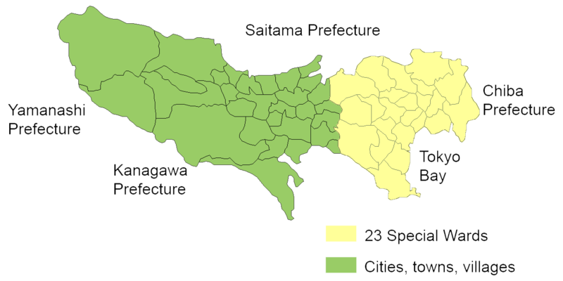
English: Map of mainland portion of Tokyo showing neighboring prefectures and Tokyo Bay
Deutsch: Karte der Präfektur Tokio, Gelb: die 23 Sonderbezirke; Grün: umliegende Gemeinden
Thanks to Aoki Shigenobu and [1]
Other versions:
- Italian: Image:TokyoMapCurrent it.png

|
Shigenobu AOKI, the copyright holder of this work, allows anyone to use it for any purpose including unrestricted redistribution, commercial use, and modification. |
File history
Click on a date/time to view the file as it appeared at that time.
| Date/Time | Thumbnail | Dimensions | User | Comment | |
|---|---|---|---|---|---|
| current | 20:29, 23 September 2006 | | 1,280 × 640 (54 KB) | JR98664 (talk | contribs) | |
| 01:55, 24 April 2005 |  | 1,440 × 801 (43 KB) | Fg2 (talk | contribs) | Replaced color in key | |
| 11:52, 23 April 2005 |  | 1,440 × 801 (43 KB) | Fg2 (talk | contribs) |
You cannot overwrite this file.
File usage on Commons
There are no pages that use this file.
File usage on other wikis
The following other wikis use this file:
- Usage on en.wikipedia.org