File:Thessaloniki historical center el.svg
Jump to navigation
Jump to search

Size of this PNG preview of this SVG file: 470 × 599 pixels. Other resolutions: 188 × 240 pixels | 376 × 480 pixels | 602 × 768 pixels | 803 × 1,024 pixels | 1,606 × 2,048 pixels | 741 × 945 pixels.
Original file (SVG file, nominally 741 × 945 pixels, file size: 272 KB)
Captions
Captions
Add a one-line explanation of what this file represents
Summary[edit]

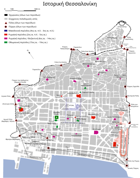
| Description | Map of the historical center of Thessaloniki (Salonica), Greece, showing greek, roman, byzantine and ottoman monuments. |
| Date | |
| Source | Translation of Image:Thessaloniki historical center.svg by Marsyas, drawn after a map by the 9th Ephorate of Byzantine Antiquities, Thessaloniki. Additional information as per Vakalopoulos, History of Thessaloniki, 1983. |
| Author | Original by Marsyas, transl. in greek by Badseed |
| Permission (Reusing this file) |
GFDL |
| Other versions |
[]
|


Licensing[edit]

|
Permission is granted to copy, distribute and/or modify this document under the terms of the GNU Free Documentation License, Version 1.2 or any later version published by the Free Software Foundation; with no Invariant Sections, no Front-Cover Texts, and no Back-Cover Texts. A copy of the license is included in the section entitled GNU Free Documentation License. |
| This file is licensed under the Creative Commons Attribution-Share Alike 3.0 Unported license. | ||
| ||
| This licensing tag was added to this file as part of the GFDL licensing update. |
File history
Click on a date/time to view the file as it appeared at that time.
| Date/Time | Thumbnail | Dimensions | User | Comment | |
|---|---|---|---|---|---|
| current | 07:06, 25 June 2020 | | 741 × 945 (272 KB) | Gts-tg (talk | contribs) | Updates: * Gates * Towers * Converted texts to editable texts * added Las Incantadas monument, Caravan Serayi, Venus temple * Small realignments |
| 00:34, 25 April 2007 |  | 723 × 944 (964 KB) | Badseed (talk | contribs) | update | |
| 12:11, 23 January 2007 |  | 723 × 944 (959 KB) | Badseed (talk | contribs) | {{Information |Description=Map of the historical center of Thessaloniki (Salonica), Greece, showing greek, roman, byzantine and ottoman monuments. |Source=Translation of Image:Thessaloniki historical center.svg by User:Marsyas, drawn after a map |
You cannot overwrite this file.
File usage on Commons
The following 10 pages use this file:
- User:Magog the Ogre/Multilingual legend/2020 June 21-30
- User:SVGbot/Results
- File:Thessaloniki historic city centre.svg
- File:Thessaloniki historical center.svg
- File:Thessaloniki historical center el.svg
- File:Thessaloniki historical center el2.png
- File:Thessaloniki historical center es.svg
- File:Thessaloniki historical center mk.svg
- File:Thessaloniki historical center uk.svg
- Template:Other versions/Thessaloniki historical center
File usage on other wikis
The following other wikis use this file:
- Usage on el.wikipedia.org