File:Theoretical Search Area of MH370 v.2.svg
Jump to navigation
Jump to search

Size of this PNG preview of this SVG file: 800 × 533 pixels. Other resolutions: 320 × 213 pixels | 640 × 427 pixels | 1,024 × 683 pixels | 1,280 × 853 pixels | 2,560 × 1,707 pixels | 1,050 × 700 pixels.
Original file (SVG file, nominally 1,050 × 700 pixels, file size: 1.09 MB)
Captions
Captions
Add a one-line explanation of what this file represents
Summary
[edit]
| Description |
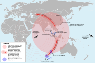
English: SVG map of the area where Malaysia Airlines Flight 370 could be found theoretically, version 2. |
| Date | |
| Source |
This file was derived from: Theoretical Search Area MH370.en.svg |
| Author |
|
| This is a retouched picture, which means that it has been digitally altered from its original version. Modifications: planned fight path simplified and corrected as in [1], the military radar data added according to [2], minor corrections. The original can be viewed here: Theoretical Search Area MH370.en.svg:
|
Licensing
[edit]
This file is licensed under the Creative Commons Attribution-Share Alike 3.0 Unported license.
- You are free:
- to share – to copy, distribute and transmit the work
- to remix – to adapt the work
- Under the following conditions:
- attribution – You must give appropriate credit, provide a link to the license, and indicate if changes were made. You may do so in any reasonable manner, but not in any way that suggests the licensor endorses you or your use.
- share alike – If you remix, transform, or build upon the material, you must distribute your contributions under the same or compatible license as the original.
File history
Click on a date/time to view the file as it appeared at that time.
| Date/Time | Thumbnail | Dimensions | User | Comment | |
|---|---|---|---|---|---|
| current | 19:09, 27 June 2014 | | 1,050 × 700 (1.09 MB) | Ain92 (talk | contribs) | +first search areas |
| 14:12, 27 June 2014 |  | 1,050 × 700 (1.09 MB) | Ain92 (talk | contribs) | User created page with UploadWizard |
You cannot overwrite this file.
File usage on Commons
The following page uses this file:
File usage on other wikis
The following other wikis use this file:
- Usage on cs.wikipedia.org