File:The DuPont Corridor.jpg
Jump to navigation
Jump to search

Size of this preview: 778 × 600 pixels. Other resolutions: 311 × 240 pixels | 623 × 480 pixels | 817 × 630 pixels.
Original file (817 × 630 pixels, file size: 54 KB, MIME type: image/jpeg)
Captions
Captions
Add a one-line explanation of what this file represents
Summary[edit]
| Description |
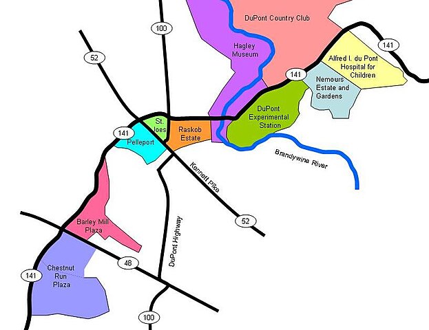
English: Map of historic institutions and residences related to the DuPont company and family and located along Delaware Route 141. |
| Source | Own work |
| Author | Littleinfo |
Licensing[edit]
| I, the copyright holder of this work, release this work into the public domain. This applies worldwide. In some countries this may not be legally possible; if so: I grant anyone the right to use this work for any purpose, without any conditions, unless such conditions are required by law. |
File history
Click on a date/time to view the file as it appeared at that time.
| Date/Time | Thumbnail | Dimensions | User | Comment | |
|---|---|---|---|---|---|
| current | 00:19, 25 August 2010 | | 817 × 630 (54 KB) | Littleinfo (talk | contribs) | The original file was cropped |
| 00:16, 25 August 2010 |  | 960 × 720 (58 KB) | Littleinfo (talk | contribs) | {{Information |Description={{en|1=Map of historic institutions and residences related to the DuPont company and family and located along Delaware Route 171}} |Source={{own}} |Author=Littleinfo |Date= |Permission= |other_version |
You cannot overwrite this file.
File usage on Commons
There are no pages that use this file.
File usage on other wikis
The following other wikis use this file:
- Usage on en.wikipedia.org