File:Tamil Nadu locator map-2010-29-10.svg
Jump to navigation
Jump to search

Size of this PNG preview of this SVG file: 484 × 599 pixels. Other resolutions: 194 × 240 pixels | 387 × 480 pixels | 620 × 768 pixels | 827 × 1,024 pixels | 1,654 × 2,048 pixels | 1,598 × 1,979 pixels.
Original file (SVG file, nominally 1,598 × 1,979 pixels, file size: 412 KB)
Captions
Captions
Add a one-line explanation of what this file represents
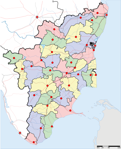
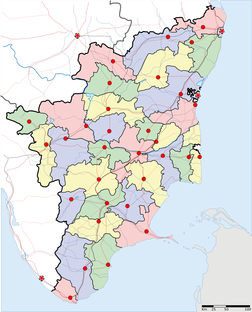
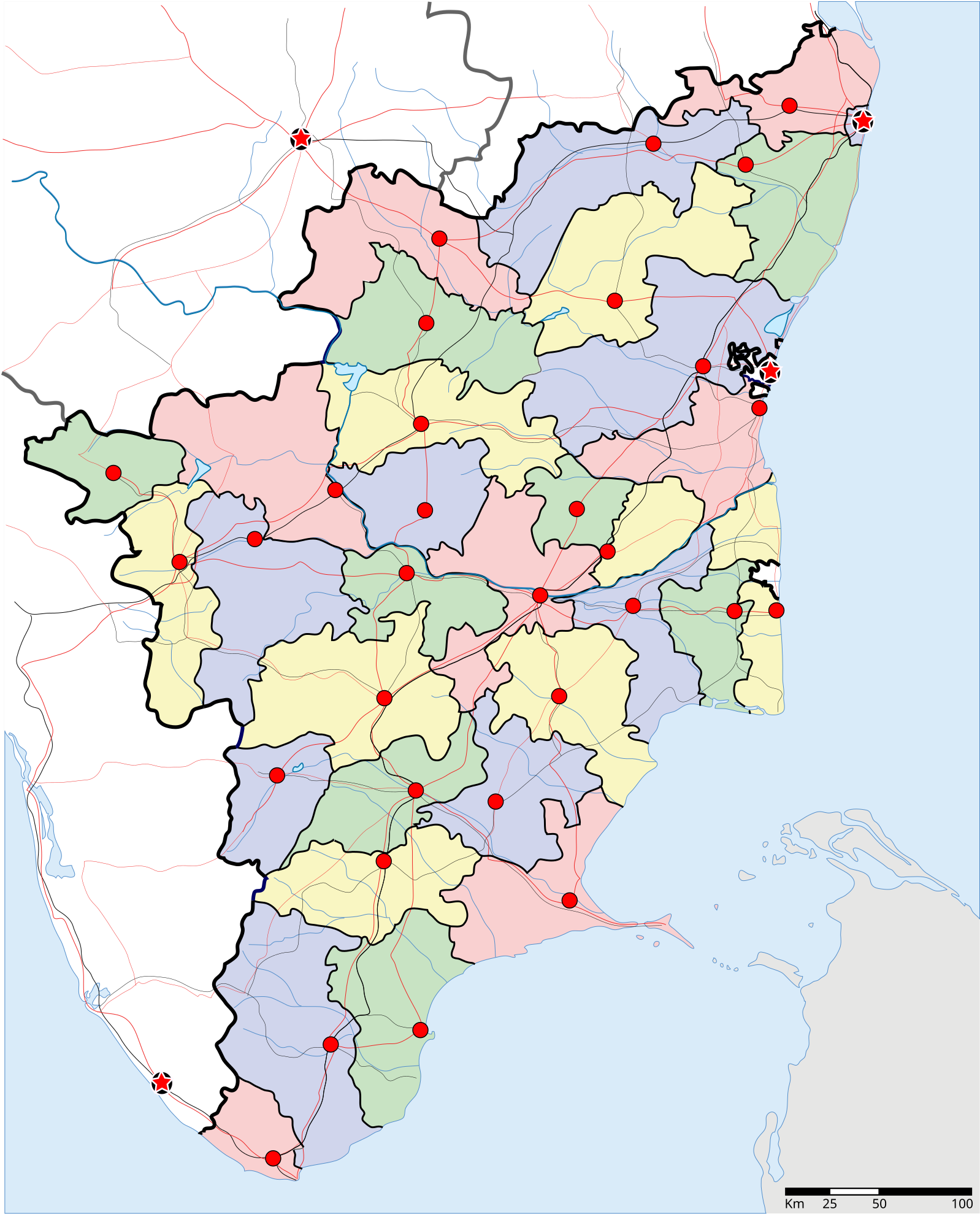
| Description | Locator map of the state of Tamil Nadu, India with district boundaries |
| Date | (UTC) |
| Source | |
| Author |
|
| This is a retouched picture, which means that it has been digitally altered from its original version. Modifications: state name in tamil. The original can be viewed here: Tamil Nadu locator map.svg:
|
I, the copyright holder of this work, hereby publish it under the following license:
This file is licensed under the Creative Commons Attribution-Share Alike 3.0 Unported license.
- You are free:
- to share – to copy, distribute and transmit the work
- to remix – to adapt the work
- Under the following conditions:
- attribution – You must give appropriate credit, provide a link to the license, and indicate if changes were made. You may do so in any reasonable manner, but not in any way that suggests the licensor endorses you or your use.
- share alike – If you remix, transform, or build upon the material, you must distribute your contributions under the same or compatible license as the original.
Original upload log[edit]
This image is a derivative work of the following images:
- File:Tamil_Nadu_locator_map.svg licensed with Cc-by-sa-3.0
- 2007-04-02T10:30:42Z Planemad 1591x1975 (121634 Bytes) {{WikiProject_India_Maps |Title=Tamil Nadu locator map |Description=Locator map of the state of Tamil Nadu, [[w:India|India]] with district boundaries |Source=. |Date=2 April 2007 |Author=[[w:user:Planemad]] }} [[Category:Wi
Uploaded with derivativeFX
File history
Click on a date/time to view the file as it appeared at that time.
| Date/Time | Thumbnail | Dimensions | User | Comment | |
|---|---|---|---|---|---|
| current | 05:39, 29 October 2010 | | 1,598 × 1,979 (412 KB) | Wikimed78 (talk | contribs) | {{Information |Description=Locator map of the state of Tamil Nadu, India with district boundaries |Source=*File:Tamil_Nadu_locator_map.svg |Date=2010-10-29 05:37 (UTC) |Author=*File:Tamil_Nadu_locator_map.svg: '''with Ariyalur dist |
| 05:22, 29 October 2010 |  | 1,598 × 1,979 (424 KB) | Wikimed78 (talk | contribs) | {{Information |Description=Locator map of the state of Tamil Nadu, India with district boundaries |Source=*File:Tamil_Nadu_locator_map.svg |Date=2010-10-29 05:21 (UTC) |Author=*File:Tamil_Nadu_locator_map.svg: '''State name in tami | |
| 05:06, 29 October 2010 |  | 744 × 1,052 (420 KB) | Wikimed78 (talk | contribs) | {{Information |Description=Locator map of the state of Tamil Nadu, India with district boundaries |Source=*File:Tamil_Nadu_locator_map.svg |Date=2010-10-29 05:04 (UTC) |Author=*File:Tamil_Nadu_locator_map.svg: '''state name in tami | |
| 04:39, 29 October 2010 |  | 744 × 1,052 (420 KB) | Wikimed78 (talk | contribs) | {{Information |Description=Locator map of the state of Tamil Nadu, India with district boundaries |Source=*File:Tamil_Nadu_locator_map.svg |Date=2010-10-29 04:36 (UTC) |Author=*File:Tamil_Nadu_locator_map.svg: '''state name in tami |
You cannot overwrite this file.
File usage on Commons
There are no pages that use this file.
File usage on other wikis
The following other wikis use this file:
- Usage on mr.wikipedia.org
- तमिळनाडू
- चेन्नई
- चेन्नई जिल्हा
- धर्मपुरी जिल्हा
- इरोड जिल्हा
- कांचीपुरम जिल्हा
- करुर जिल्हा
- मदुराई जिल्हा
- नागपट्टिनम जिल्हा
- पेराम्बलुर जिल्हा
- सेलम जिल्हा
- शिवगंगा जिल्हा
- तिरुचिरापल्ली जिल्हा
- तेनी जिल्हा
- तिरुनलवेली जिल्हा
- तूतुकुडी जिल्हा
- तिरुवल्लूर जिल्हा
- तिरुवरुर जिल्हा
- विलुपुरम जिल्हा
- विरुधुनगर जिल्हा
- कन्याकुमारी जिल्हा
- निलगिरी जिल्हा
- कोइंबतूर
- कडलूर
- धर्मपुरी
- इरोड
- कांचीपुरम
- नागरकोविल
- उदगमंडलम
- पेराम्बलुर
- रामनाथपुरम
- सेलम
- शिवगंगा
- तिरुचिरापल्ली
- तेनी
- तिरुनलवेली
- तूतुकुडी
- तिरुवल्लूर
- तिरुवरुर
- तिरुवनमलाई
- विलुपुरम
- एम.जी. रामचंद्रन
- कन्याकुमारी
- पालक्काड खिंड
- आनैमलाई पर्वतरांग
- मयिलापूर
- कुंभकोणम
- शिवकाशी
- तेनकाशी
- पलानी
View more global usage of this file.