File:Syria Ethnoreligious Map.png
Jump to navigation
Jump to search

Size of this preview: 711 × 600 pixels. Other resolutions: 285 × 240 pixels | 569 × 480 pixels | 910 × 768 pixels | 1,214 × 1,024 pixels | 1,778 × 1,500 pixels.
Original file (1,778 × 1,500 pixels, file size: 373 KB, MIME type: image/png)
Captions
Captions
Add a one-line explanation of what this file represents
| Description |
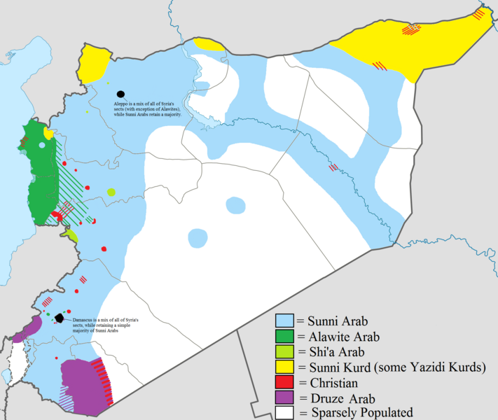
English: Map showing the ethnic and religious distribution of Syria's sects. Very useful map that helps clarify Syria's composition. |
| Date | 8/10/12 |
| Source | File:Syria location map2.svg |
| Author | Supreme Deliciousness |
| Permission (Reusing this file) |
http://en.wikipedia.org/wiki/File:Syria_location_map2.svg |
This file is licensed under the Creative Commons Attribution-Share Alike 1.0 Generic license.
- You are free:
- to share – to copy, distribute and transmit the work
- to remix – to adapt the work
- Under the following conditions:
- attribution – You must give appropriate credit, provide a link to the license, and indicate if changes were made. You may do so in any reasonable manner, but not in any way that suggests the licensor endorses you or your use.
- share alike – If you alter, transform, or build upon this work, you must distribute the resulting work under the same license as the original.
File history
Click on a date/time to view the file as it appeared at that time.
| Date/Time | Thumbnail | Dimensions | User | Comment | |
|---|---|---|---|---|---|
| current | 21:31, 19 August 2012 | | 1,778 × 1,500 (373 KB) | Moester101 (talk | contribs) | More polishing to respond to Wustenfuchs' concerns. |
| 06:20, 19 August 2012 |  | 1,778 × 1,500 (372 KB) | Moester101 (talk | contribs) | updated to reflect new source provided by Wustenfuchs. See talk page of file. | |
| 10:32, 12 August 2012 |  | 1,778 × 1,500 (372 KB) | Moester101 (talk | contribs) | Distinguish between Sunni Arab lands and sparsely populated lands, and also added the sources of the map. See talk Page. | |
| 08:32, 11 August 2012 |  | 1,778 × 1,500 (343 KB) | Moester101 (talk | contribs) | {{subst:Upload marker added by en.wp UW}} {{Information |Description = {{en|Map showing the ethnic and religious distribution of Syria's sects. Very useful map that helps clarify Syria's composition.}} |Source = File:Syria location map2.svg |Date = 8/1... |
You cannot overwrite this file.
File usage on Commons
The following 2 pages use this file:
File usage on other wikis
The following other wikis use this file:
- Usage on bg.wikipedia.org
- Usage on de.wikipedia.org
- Usage on en.wikipedia.org
- Usage on fr.wikipedia.org
- Usage on hu.wikipedia.org
- Usage on nl.wikipedia.org
- Usage on pt.wikipedia.org