File:Sykes Ras el Ain to Nissibine map Page 21.jpg
Jump to navigation
Jump to search
Size of this preview: 397 × 599 pixels. Other resolutions: 159 × 240 pixels | 318 × 480 pixels | 509 × 768 pixels | 679 × 1,024 pixels | 1,358 × 2,048 pixels | 4,200 × 6,334 pixels.
Original file (4,200 × 6,334 pixels, file size: 1.42 MB, MIME type: image/jpeg)
Captions
Captions
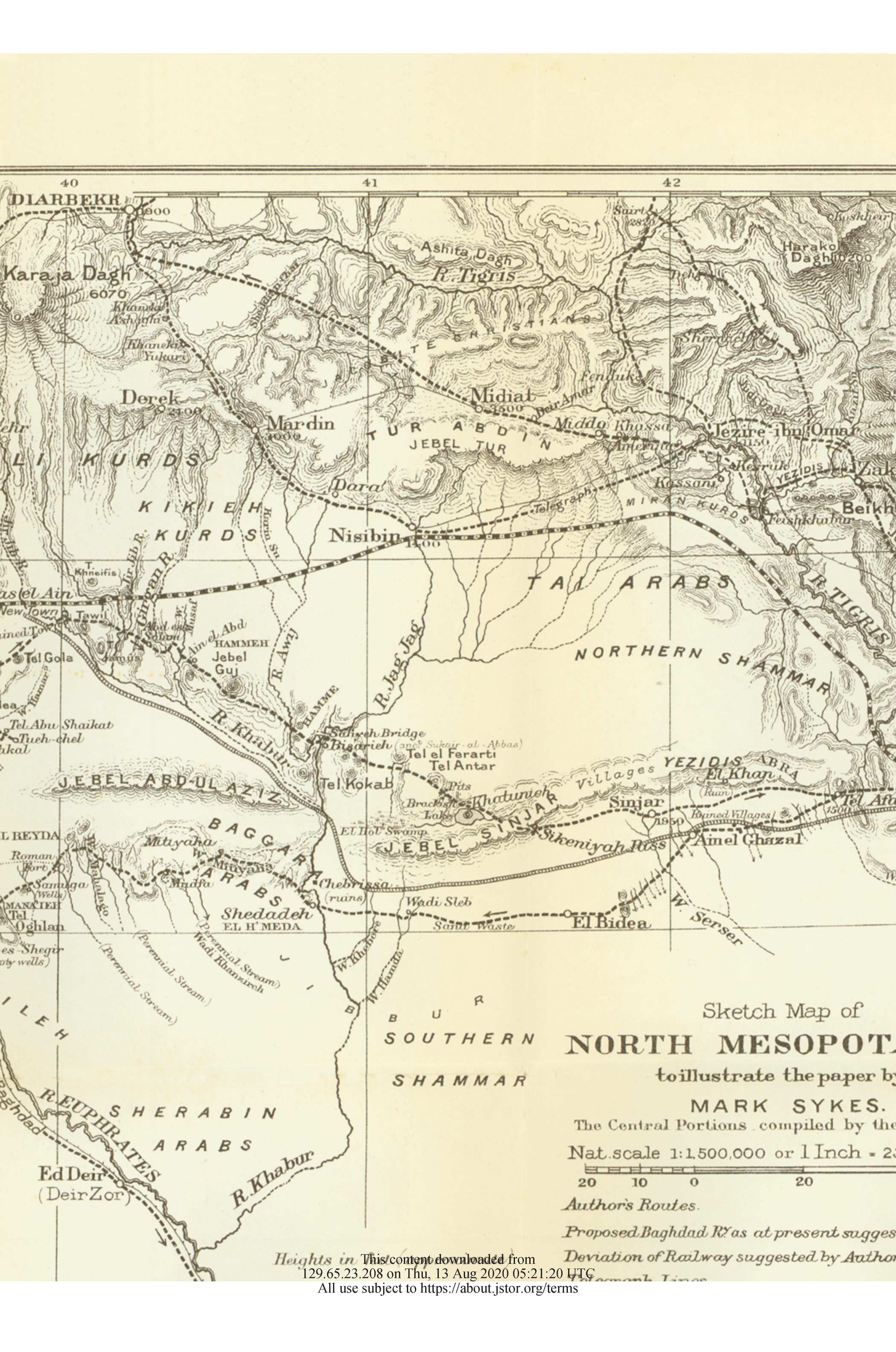
Map showing distribution of Arab and Kurdish tribes in upper Mesopotamia
Summary[edit]
| Description |
English: Map showing distribution of Arab and Kurdish tribes in upper Mesopotamia. According to the Treaty of Lausanne, the railway track visible in the map was used as the border between Turkey and Syria in this section of the border. The areas north of the track were given to Turkey while the areas south of track were given to Syria. |
| Date | |
| Source | The Geographical Journal , Sep., 1907, Vol. 30, No. 3 (Sep., 1907), pp. 237-254 |
| Author | Mark Sykes |
Licensing[edit]
This work is in the public domain in the United States because it was published (or registered with the U.S. Copyright Office) before January 1, 1929.
Public domain works must be out of copyright in both the United States and in the source country of the work in order to be hosted on the Commons. If the work is not a U.S. work, the file must have an additional copyright tag indicating the copyright status in the source country.
Note: This tag should not be used for sound recordings. |
File history
Click on a date/time to view the file as it appeared at that time.
| Date/Time | Thumbnail | Dimensions | User | Comment | |
|---|---|---|---|---|---|
| current | 06:02, 17 November 2020 | | 4,200 × 6,334 (1.42 MB) | عمرو بن كلثوم (talk | contribs) | Uploaded a work by Mark Sykes from The Geographical Journal , Sep., 1907, Vol. 30, No. 3 (Sep., 1907), pp. 237-254 with UploadWizard |
You cannot overwrite this file.
File usage on Commons
The following page uses this file:
File usage on other wikis
The following other wikis use this file:
- Usage on en.wikipedia.org
- Usage on tr.wikipedia.org