File:Strong impact of the drought on the Danube River.jpg
Original file (4,003 × 4,066 pixels, file size: 4.28 MB, MIME type: image/jpeg)
Captions
Captions
Summary[edit]
| Description |
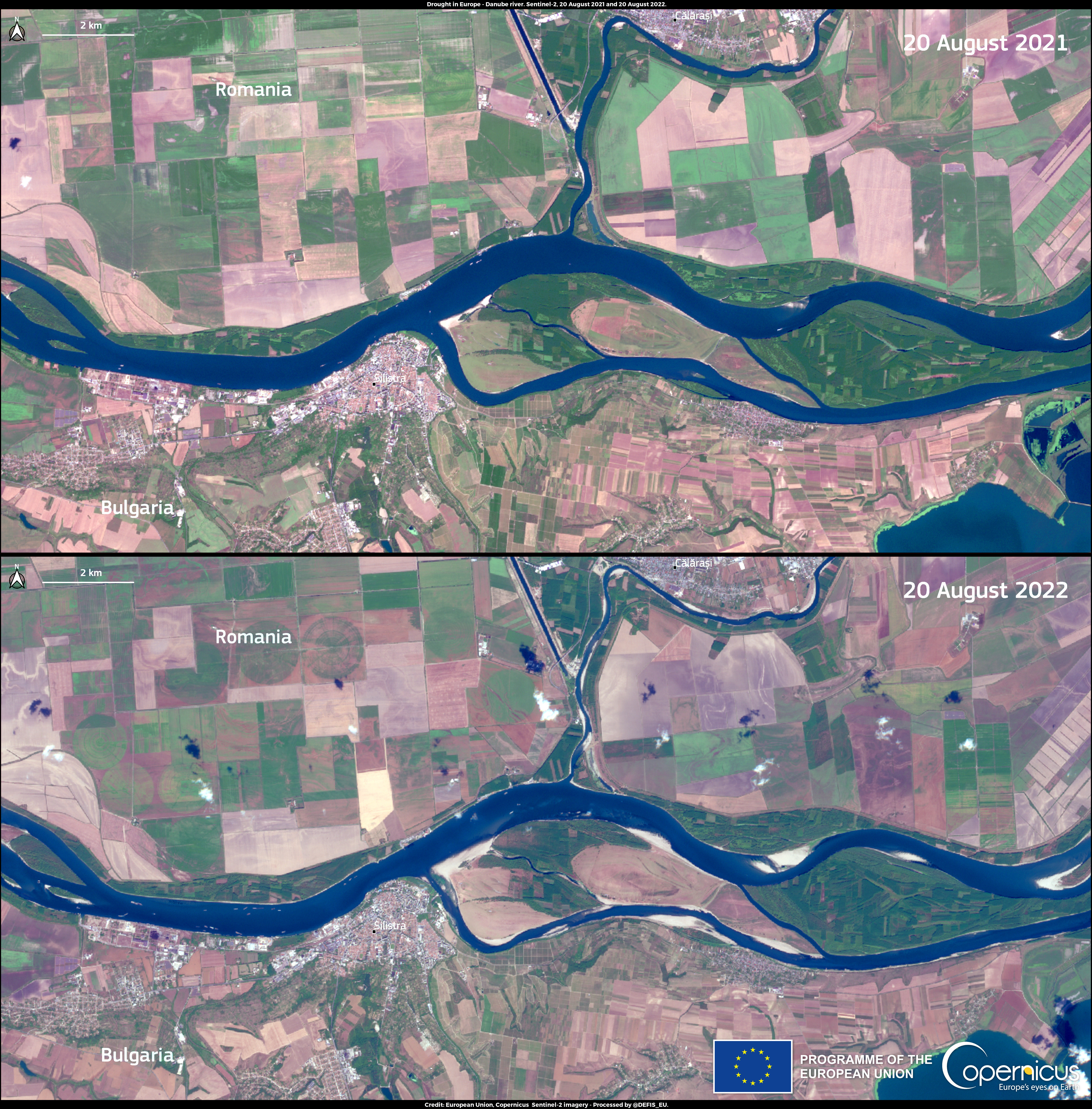
English: These images, acquired by the Copernicus Sentinel-2A and Sentinel-2B satellites on 20 August 2021 and 20 August 2022, provide evidence of the water scarcity which is affecting the Danube River in a segment which delineates the border between Bulgaria and Romania. The Danube River is one of the most important trade routes in Western Europe. Along with all other major European rivers, it has been strongly affected by the consequences of the extreme drought conditions ongoing in Europe. In some parts of western Europe, in fact, the Danube is unnavigable. On 12 August, the water level at Tulcea, in Romania, stood at 51 cm (data from the Danube Fairway Information Service Portal), a value which is 6 cm lower than the minimum value required for navigation, and dredging is currently being performed to allow the river circulation. With an average revisit time of five days at the equator, the Copernicus Sentinel-2 satellites provide free and open data that can be used to monitor drought and its impact on ecosystems or infrastructure. |
| Date | 25 August 2022 (upload date) |
| Source | Strong impact of the drought on the Danube River |
| Author | European Union, Copernicus Sentinel-2 imagery |
Licensing[edit]

|
This image contains data from a satellite in the Copernicus Programme, such as Sentinel-1, Sentinel-2 or Sentinel-3. Attribution is required when using this image.
Attribution: Contains modified Copernicus Sentinel data 2022
The use of Copernicus Sentinel Data is regulated under EU law (Commission Delegated Regulation (EU) No 1159/2013 and Regulation (EU) No 377/2014). Relevant excerpts:
Free access shall be given to GMES dedicated data [...] made available through GMES dissemination platforms [...].
Access to GMES dedicated data [...] shall be given for the purpose of the following use in so far as it is lawful:
GMES dedicated data [...] may be used worldwide without limitations in time.
GMES dedicated data and GMES service information are provided to users without any express or implied warranty, including as regards quality and suitability for any purpose. |
File history
Click on a date/time to view the file as it appeared at that time.
| Date/Time | Thumbnail | Dimensions | User | Comment | |
|---|---|---|---|---|---|
| current | 15:38, 14 August 2023 | | 4,003 × 4,066 (4.28 MB) | OptimusPrimeBot (talk | contribs) | #Spacemedia - Upload of https://www.copernicus.eu/system/files/2022-08/image_day/20220825_DroughtInEurope_DanubeRiver.jpg via Commons:Spacemedia |
You cannot overwrite this file.
File usage on Commons
There are no pages that use this file.