File:Straw Mat Network At The South Of Taklimakan Desert = 砂漠化防止のための草方格(且末,チェンモ) 36556482822 7668464a2c o.jpg
Jump to navigation
Jump to search

Size of this preview: 800 × 557 pixels. Other resolutions: 320 × 223 pixels | 640 × 445 pixels | 1,024 × 712 pixels | 1,280 × 890 pixels | 2,560 × 1,781 pixels | 4,416 × 3,072 pixels.
Original file (4,416 × 3,072 pixels, file size: 1.26 MB, MIME type: image/jpeg)
Captions
Captions
Add a one-line explanation of what this file represents
Summary[edit]
| Description |
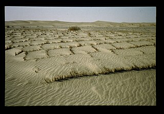
English: Author: Maki Taichi / Date: 1993.07.31 / Country: China / Place: North West Of China / Keywords: Straw Mat Network,taklimakan Desert,desertification,protection / Slide no. 02-150-09 日本語: 真木太一 (TARC) / Description: 中国のタクラマカン砂漠は南に移動している。西域南道(シルクロード)沿いでは砂丘に道路が埋まるため、アシ(ヨシ)の草方格の基盤の目状(1x1m)にして懸命に防砂を行っている。 / Project: 乾燥地域の気象・蒸散特性の解明と防風施設による風食防止 / Country: (中国) / Place: (中国北西部) / Keywords: 乾燥地域の気象・蒸散特性の解明と防風施設による風食防止,中国,中国北西部,気象(自然立地) |
| Date | |
| Source | Japan International Research Center for Agricultural Sciences |
| Author | Maki Taichi 真木太一 (TARC) |
Licensing[edit]
| This image was originally posted to Flickr by JIRCAS at https://flickr.com/photos/148158860@N03/36556482822 (archive). It was reviewed on 7 January 2020 by FlickreviewR 2 and was confirmed to be licensed under the terms of the cc-by-2.0. |
This file is licensed under the Creative Commons Attribution 2.0 Generic license.
- You are free:
- to share – to copy, distribute and transmit the work
- to remix – to adapt the work
- Under the following conditions:
- attribution – You must give appropriate credit, provide a link to the license, and indicate if changes were made. You may do so in any reasonable manner, but not in any way that suggests the licensor endorses you or your use.
File history
Click on a date/time to view the file as it appeared at that time.
| Date/Time | Thumbnail | Dimensions | User | Comment | |
|---|---|---|---|---|---|
| current | 11:00, 7 January 2020 | | 4,416 × 3,072 (1.26 MB) | Geographyinitiative (talk | contribs) | User created page with UploadWizard |
You cannot overwrite this file.
File usage on Commons
There are no pages that use this file.
_36556482822_7668464a2c_o.jpg&oldid=752726292)