File:Strassenbahn Frankfurt am Main Netzkarte.png
Jump to navigation
Jump to search

Size of this preview: 563 × 599 pixels. Other resolutions: 225 × 240 pixels | 451 × 480 pixels | 721 × 768 pixels | 962 × 1,024 pixels | 1,924 × 2,048 pixels | 3,113 × 3,314 pixels.
Original file (3,113 × 3,314 pixels, file size: 2.62 MB, MIME type: image/png)
Captions
Captions
Add a one-line explanation of what this file represents
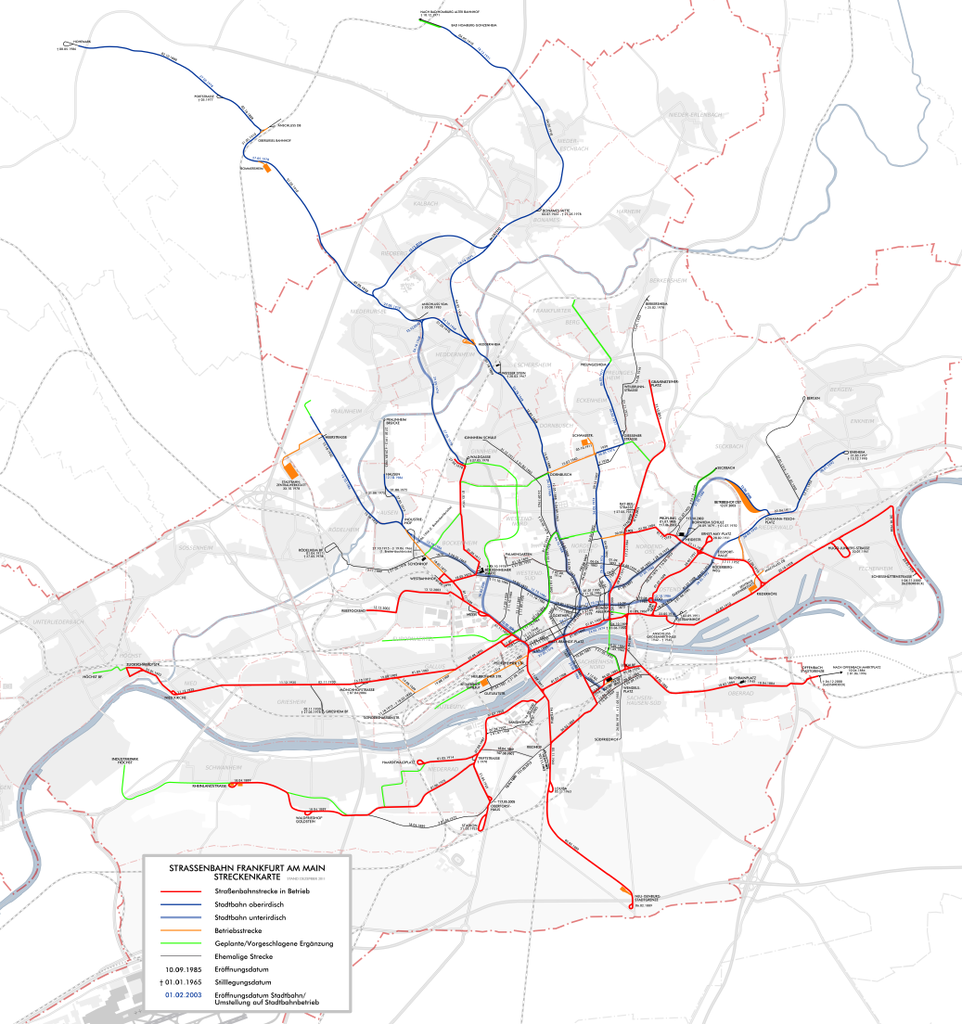
| Description | Straßenbahn Frankfurt am Main, aktuelle, ehemalige und geplante Strecken sowie U-Bahn. | ||||||||
| Date | |||||||||
| Source | selfmade, based on map by T.h. | ||||||||
| Author | P. Gross, T.h. | ||||||||
| Permission (Reusing this file) |
I, the copyright holder of this work, hereby publish it under the following licenses:
This file is licensed under the Creative Commons Attribution-Share Alike 2.5 Generic, 2.0 Generic and 1.0 Generic license.
You may select the license of your choice. |


|
This transport map image could be re-created using vector graphics as an SVG file. This has several advantages; see Commons:Media for cleanup for more information. If an SVG form of this image is available, please upload it and afterwards replace this template with
{{vector version available|new image name}}.
It is recommended to name the SVG file “Strassenbahn Frankfurt am Main Netzkarte.svg”—then the template Vector version available (or Vva) does not need the new image name parameter. |
File history
Click on a date/time to view the file as it appeared at that time.
| Date/Time | Thumbnail | Dimensions | User | Comment | |
|---|---|---|---|---|---|
| current | 18:30, 4 October 2017 | | 3,113 × 3,314 (2.62 MB) | Chumwa (talk | contribs) | corr, upd |
| 09:50, 4 December 2015 |  | 3,100 × 3,300 (2.11 MB) | Kopiersperre (talk | contribs) | optipng | |
| 20:57, 19 January 2015 |  | 3,100 × 3,300 (2.61 MB) | Chumwa (talk | contribs) | Diverse Ergänzungen | |
| 04:51, 17 December 2014 |  | 3,100 × 3,300 (2.6 MB) | Chumwa (talk | contribs) | Silllegungsdatum Lieschen auf 21. Mai 2013 geändert | |
| 04:34, 15 December 2014 |  | 3,100 × 3,300 (2.6 MB) | Chumwa (talk | contribs) | Lieschen raus, Gallus Süd nur noch Betriebsstrecke | |
| 19:51, 14 December 2014 |  | 3,100 × 3,300 (2.59 MB) | Chumwa (talk | contribs) | Fahrplanwechsel 14.12.2014 | |
| 18:52, 29 October 2012 |  | 3,100 × 3,300 (2.6 MB) | Chumwa (talk | contribs) | corr | |
| 20:02, 16 January 2012 |  | 3,100 × 3,300 (2.55 MB) | Chumwa (talk | contribs) | Planung der Ginnheimer Kurve korrigiert und geplante Strecke zum Frankfurter Berg bis zum S-Bahnhof verlängert | |
| 20:57, 15 December 2011 |  | 3,100 × 3,300 (2.6 MB) | Chumwa (talk | contribs) | Folgende Anmerkungen von V44020001 zum Fahrplanwechsel 2011/2012 eingearbeitet: Inbetriebnahme der Strecke nach Preungesheim Ost. Grünfärbung für geplante Verlängerung zum Bahnhof Bad Homburg, zum Frankfurter Berg, ins Europavie | |
| 15:41, 14 December 2011 |  | 3,100 × 3,300 (3.05 MB) | Bürgerentscheid (talk | contribs) | Eröffnung Neubaustrecke Preungesheim Ost ergänzt. |
You cannot overwrite this file.
File usage on Commons
The following 10 pages use this file:
- Straßenbahn Frankfurt am Main
- User:Chumwa/Gallery
- User:Chumwa/OgreBot/Potential transport maps/2017 October 1-10
- User:Chumwa/OgreBot/Public transport information/2015 December 1-10
- User:Chumwa/OgreBot/Public transport information/2017 October 1-10
- User:Chumwa/OgreBot/Transport Maps/2015 December 1-10
- User:Chumwa/OgreBot/Transport Maps/2017 October 1-10
- User:Chumwa/OgreBot/Travel and communication maps/2017 October 1-10
- User:Nordlicht8/Rail Germany/2015 December 1-10
- User:Philipp Gross
File usage on other wikis
The following other wikis use this file:
- Usage on de.wikipedia.org