File:Storm over the northeastern United States (9128829908).jpg

Original file (3,600 × 2,800 pixels, file size: 2.09 MB, MIME type: image/jpeg)
Captions
Captions
Summary[edit]
.jpg&action=edit§ion=1)
| Description |
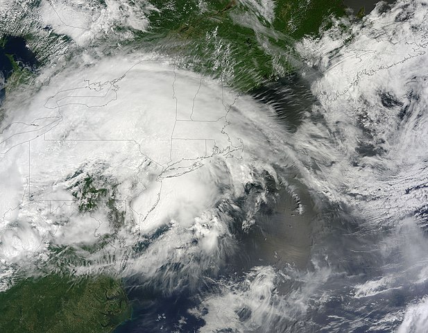
When meteorologists say derecho, which means “direct” or “straight ahead” in Spanish, they are referring to a widespread, long-lived wind storm associated with bands of fast-moving thunderstorms. This type of storm was given the name in the late ninetieth century and they occur most often in the Midwestern and Great Lakes regions for the United States between May and July. To qualify as a derecho, a storm must cause damage over a 240-mile (400-km) front/line and produce wind gusts of at least 58 miles (93 km) per hour. When a derecho barreled over the eastern United States in June 2012, the impacts were severe. That powerful storm brought hurricane-force winds to numerous states, killed 22 people, and knocked out electric power for millions. So people were bracing for the worst when a fierce line of storms was bearing down on the same area on June 13, 2013. While the 2013 storm was not as powerful or destructive as the previous year’s event, the National Weather Service said it still qualified as a “low-end derecho”. Over a 15-hour period, the storm system generated 376 reports of damaging thunderstorm wind. In one part of Indiana, a storm cell brought winds of 90-100 miles (140-160 km) per hour across an area seven miles long and three miles wide, according to meteorologist Jeff Masters. The Moderate Resolution Imaging Spectroradiometer (MODIS) aboard NASA’s Terra satellite acquired this true-color image of the storm system passing over the eastern United States on June 13. While it is not possible to make out the band where thunderstorms were strongest because of cloud cover, a composite of radar images revealed a bow-shaped band of storms – called a bow echo- propagating east at 47 miles (75 km) per hour. Credit: NASA/GSFC/Jeff Schmaltz/MODIS Land Rapid Response Team NASA Goddard Space Flight Center enables NASA’s mission through four scientific endeavors: Earth Science, Heliophysics, Solar System Exploration, and Astrophysics. Goddard plays a leading role in NASA’s accomplishments by contributing compelling scientific knowledge to advance the Agency’s mission. Follow us on Twitter Like us on Facebook Find us on Instagram |
| Date | |
| Source | Storm over the northeastern United States |
| Author | NASA Goddard Space Flight Center from Greenbelt, MD, USA |
Licensing[edit]
.jpg&action=edit§ion=2)
- You are free:
- to share – to copy, distribute and transmit the work
- to remix – to adapt the work
- Under the following conditions:
- attribution – You must give appropriate credit, provide a link to the license, and indicate if changes were made. You may do so in any reasonable manner, but not in any way that suggests the licensor endorses you or your use.
| This image was originally posted to Flickr by NASA Goddard Photo and Video at https://flickr.com/photos/24662369@N07/9128829908. It was reviewed on 17 September 2016 by FlickreviewR and was confirmed to be licensed under the terms of the cc-by-2.0. |
| This file is in the public domain in the United States because it was solely created by NASA. NASA copyright policy states that "NASA material is not protected by copyright unless noted". (See Template:PD-USGov, NASA copyright policy page or JPL Image Use Policy.) | ||
 |
Warnings:
|
File history
Click on a date/time to view the file as it appeared at that time.
| Date/Time | Thumbnail | Dimensions | User | Comment | |
|---|---|---|---|---|---|
| current | 21:01, 17 September 2016 | | 3,600 × 2,800 (2.09 MB) | Vanished Account Byeznhpyxeuztibuo (talk | contribs) | Transferred from Flickr via Flickr2Commons |
You cannot overwrite this file.
File usage on Commons
There are no pages that use this file.
.jpg&oldid=860866642)