File:Southern Border.png
Jump to navigation
Jump to search

Size of this preview: 508 × 600 pixels. Other resolutions: 203 × 240 pixels | 407 × 480 pixels | 650 × 768 pixels | 867 × 1,024 pixels | 2,000 × 2,361 pixels.
Original file (2,000 × 2,361 pixels, file size: 508 KB, MIME type: image/png)
Captions
Captions
Add a one-line explanation of what this file represents
Summary
[edit]
| Description |
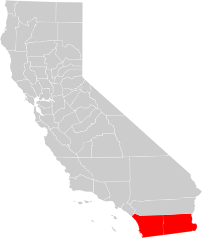
English: Map of the w:Southern Border region of California, which consists of San Diego and Imperial counties
Español: Mapa de la región de la Frontera Sur de California, que consiste en el condado de San Diego y el condado de Imperial
Français : Carte de la région frontalière du sud de la Californie, qui se compose de comté de San Diego et Imperial County
Italiano: Mappa della regione di confine meridionale della California, che consiste nella contea di San Diego e Imperial County
Português: Mapa da região da fronteira sul da Califórnia, que consiste no condado de San Diego e Imperial County |
| Date | |
| Source | Own work based on File:California county map (Imperial County highlighted).svg |
| Author | SoCal L.A. |
.svg)
Licensing
[edit]
| I, the copyright holder of this work, release this work into the public domain. This applies worldwide. In some countries this may not be legally possible; if so: I grant anyone the right to use this work for any purpose, without any conditions, unless such conditions are required by law. |
File history
Click on a date/time to view the file as it appeared at that time.
| Date/Time | Thumbnail | Dimensions | User | Comment | |
|---|---|---|---|---|---|
| current | 22:12, 16 March 2010 | | 2,000 × 2,361 (508 KB) | SoCal L.A. (talk | contribs) | {{Information |Description={{en|1=Map of the w:Southern Border region of California, which consists of San Diego and Imperial counties}} {{es|1=Mapa de la región de la Frontera Sur de California, que consiste en el condado de San Diego y el condado d |
You cannot overwrite this file.
File usage on Commons
There are no pages that use this file.