File:Southern-thailand-regions.png
Jump to navigation
Jump to search
Size of this preview: 583 × 599 pixels. Other resolutions: 233 × 240 pixels | 467 × 480 pixels | 747 × 768 pixels | 996 × 1,024 pixels | 1,998 × 2,054 pixels.
Original file (1,998 × 2,054 pixels, file size: 846 KB, MIME type: image/png)
Captions
Captions
Add a one-line explanation of what this file represents
Summary[edit]
| Description |
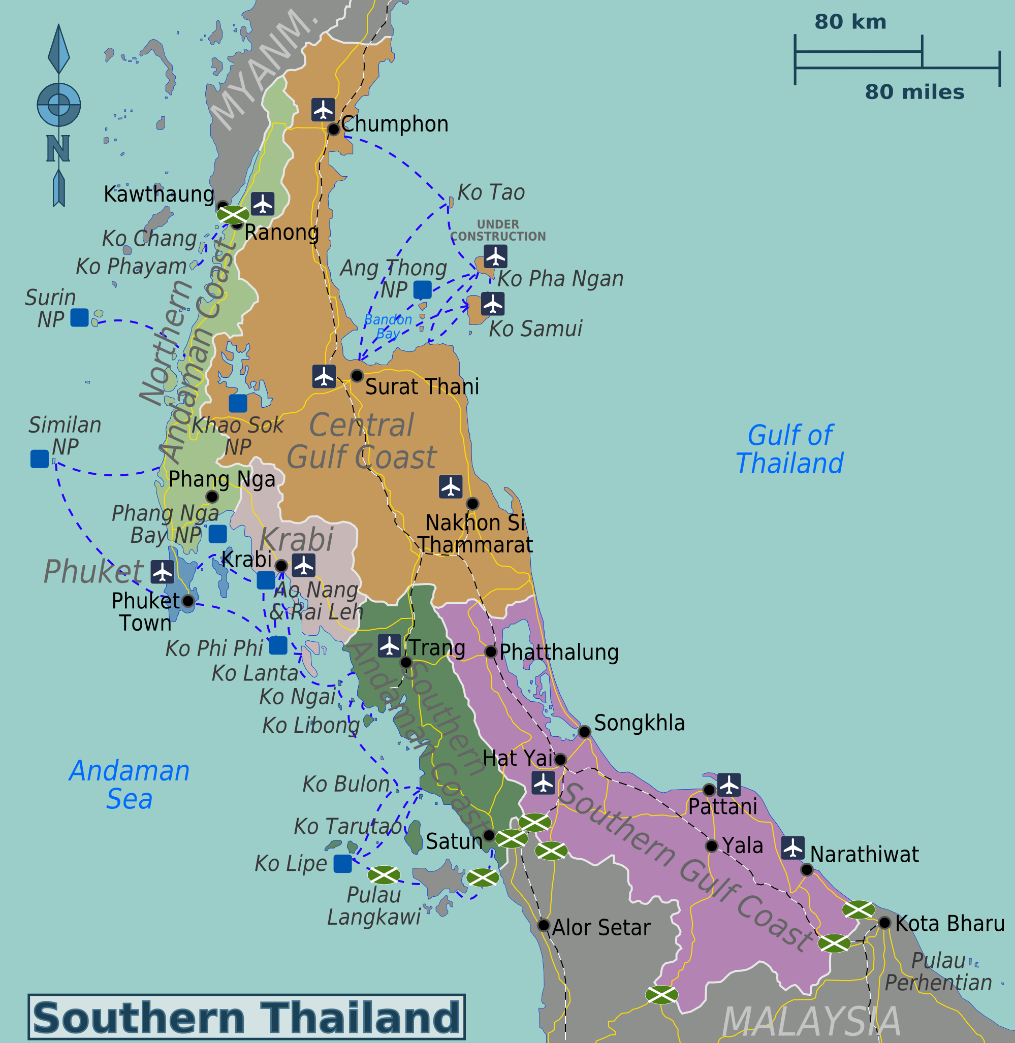
English: Map of Southern Thailand. |
| Date | |
| Source | Own work based on the Perry-Castañeda Library Map Collection - University of Texas Libraries (public domain). |
| Author | Globe-trotter |
| Other versions | SVG base file |
Licensing[edit]
This file is licensed under the Creative Commons Attribution-Share Alike 3.0 Unported license.
- You are free:
- to share – to copy, distribute and transmit the work
- to remix – to adapt the work
- Under the following conditions:
- attribution – You must give appropriate credit, provide a link to the license, and indicate if changes were made. You may do so in any reasonable manner, but not in any way that suggests the licensor endorses you or your use.
- share alike – If you remix, transform, or build upon the material, you must distribute your contributions under the same or compatible license as the original.
Original upload log[edit]
| This file was imported from Wikivoyage WTS. |
The original description page was here. All following user names refer to wts.wikivoyage-old.
- 2011-08-25 02:35 (WT-shared) Globe-trotter[dead link] 1998×2054 (756502 bytes) {{Imagecredit|credit=Globe-trotter|captureDate=August 25, 2011|location=Thailand|source=[http://wikitravel.org/shared/Image:Thailand-regions (Import from wikitravel.org/shared)
File history
Click on a date/time to view the file as it appeared at that time.
| Date/Time | Thumbnail | Dimensions | User | Comment | |
|---|---|---|---|---|---|
| current | 03:20, 7 November 2014 | | 1,998 × 2,054 (846 KB) | Gezginrocker (talk | contribs) | Added more ferry routes. |
| 18:29, 6 November 2014 |  | 1,998 × 2,054 (841 KB) | Gezginrocker (talk | contribs) | Added more ferry routes and roads. | |
| 00:03, 1 November 2014 |  | 1,998 × 2,054 (830 KB) | Gezginrocker (talk | contribs) | Added new border crossing icons, minor fixes | |
| 18:58, 30 October 2014 |  | 1,998 × 2,054 (813 KB) | Gezginrocker (talk | contribs) | Added airports and done general fixes. | |
| 03:27, 30 October 2014 |  | 1,998 × 2,054 (800 KB) | Gezginrocker (talk | contribs) | Ferry routes added. | |
| 09:47, 11 October 2014 |  | 2,000 × 2,056 (801 KB) | Saqib (talk | contribs) | minor | |
| 09:46, 11 October 2014 |  | 2,000 × 2,056 (801 KB) | Saqib (talk | contribs) | minor | |
| 23:20, 29 May 2014 |  | 1,998 × 2,054 (801 KB) | Gezginrocker (talk | contribs) | Added new locations. | |
| 23:11, 29 May 2014 |  | 1,998 × 2,054 (739 KB) | Gezginrocker (talk | contribs) | Reverted to version as of 02:51, 18 November 2012 | |
| 23:11, 29 May 2014 |  | 1,998 × 2,054 (739 KB) | Gezginrocker (talk | contribs) | Reverted to version as of 02:51, 18 November 2012 |
You cannot overwrite this file.
File usage on Commons
The following page uses this file:
File usage on other wikis
The following other wikis use this file:
- Usage on de.wikivoyage.org
- Usage on en.wikivoyage.org
- Usage on fr.wikivoyage.org
- Usage on he.wikivoyage.org
- Usage on pt.wikivoyage.org
- Usage on shn.wikivoyage.org
- Usage on vi.wikivoyage.org