File:Somalian Piracy Threat 2010 map-fr.svg
Jump to navigation
Jump to search

Size of this PNG preview of this SVG file: 800 × 575 pixels. Other resolutions: 320 × 230 pixels | 640 × 460 pixels | 1,024 × 736 pixels | 1,280 × 920 pixels | 2,560 × 1,840 pixels | 3,389 × 2,436 pixels.
Original file (SVG file, nominally 3,389 × 2,436 pixels, file size: 2.88 MB)
Captions
Captions
Add a one-line explanation of what this file represents
Summary[edit]
| Description |
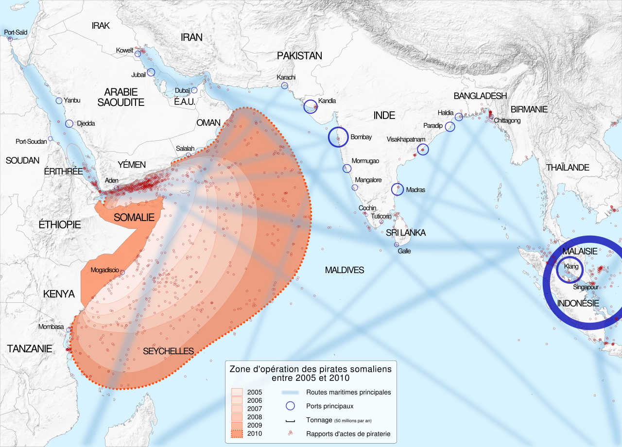
English: Map showing the extent of Somali pirate attacks on shipping vessels between 2005 and 2010. Français : Carte montrant l'expansion des attaques de pirates somaliens sur des navires de transport entre 2005 et 2010. |
||||
| Date | (UTC) | ||||
| Source |
This file was derived from: Somalian Piracy Threat Map 2010.png |
||||
| Author |
|
||||
| Other versions |
| ||||
| Attribution (required by the license) | © Sémhur / Wikimedia Commons / | ||||
| SVG | W3C-validity not checked.
|
||||
| Graphic Lab |

| Camera location | | View this and other nearby images on: OpenStreetMap |
|---|
Licensing[edit]
I, the copyright holder of this work, hereby publish it under the following licenses:
| Copyleft: This work of art is free; you can redistribute it and/or modify it according to terms of the Free Art License. You will find a specimen of this license on the Copyleft Attitude site as well as on other sites. |
This file is licensed under the Creative Commons Attribution-Share Alike Attribution-Share Alike 4.0 International, 3.0 Unported, 2.5 Generic, 2.0 Generic and 1.0 Generic license.
- You are free:
- to share – to copy, distribute and transmit the work
- to remix – to adapt the work
- Under the following conditions:
- attribution – You must give appropriate credit, provide a link to the license, and indicate if changes were made. You may do so in any reasonable manner, but not in any way that suggests the licensor endorses you or your use.
- share alike – If you remix, transform, or build upon the material, you must distribute your contributions under the same or compatible license as the original.
You may select the license of your choice.
Original upload log[edit]
This image is a derivative work of the following images:
- File:Somalian_Piracy_Threat_Map_2010.png licensed with Cc-by-sa-3.0
- 2012-02-12T21:00:12Z Quibik 3389x2396 (2093094 Bytes) Removed the data surce information too: this belongs in the image description.
- 2012-02-12T20:18:30Z Jbarta 3389x2396 (2134759 Bytes) remove unnecessary text
- 2011-01-21T12:11:45Z Planemad 3389x2396 (2111070 Bytes) port legibility
- 2011-01-21T12:08:36Z Planemad 1716x2426 (830651 Bytes) port legibility
- 2011-01-21T12:04:30Z Planemad 3389x2396 (2102523 Bytes) port legibility
- 2011-01-21T12:00:10Z Planemad 3389x2396 (2090238 Bytes) update with asam locations and ethiopia typo
- 2010-12-31T17:10:28Z Planemad 3389x2396 (2074205 Bytes) {{Information |Description={{en|1=test}} |Source={{own}} |Author=[[User:Planemad|Planemad]] |Date=2010-12-31 |Permission= |other_versions= }}
Uploaded with derivativeFX
File history
Click on a date/time to view the file as it appeared at that time.
| Date/Time | Thumbnail | Dimensions | User | Comment | |
|---|---|---|---|---|---|
| current | 11:49, 30 May 2014 | | 3,389 × 2,436 (2.88 MB) | Sémhur (talk | contribs) | Valid SVG |
| 19:28, 19 March 2012 |  | 3,389 × 2,436 (2.88 MB) | Sémhur (talk | contribs) | Malaysie => Malaisie | |
| 15:44, 19 March 2012 |  | 3,389 × 2,436 (2.88 MB) | Sémhur (talk | contribs) | Good dimensions | |
| 15:17, 19 March 2012 |  | 512 × 368 (2.73 MB) | Sémhur (talk | contribs) | == {{int:filedesc}} == {{Information |Description={{Multilingual description |en= Map showing the extent of Somali pirate attacks on shipping vessels between 2005 and 2010. |fr= Carte montrant l'expansion des attaques de [[:f... |
You cannot overwrite this file.
File usage on Commons
The following 2 pages use this file:
File usage on other wikis
The following other wikis use this file:
- Usage on ca.wikipedia.org
- Usage on de.wikipedia.org
- Usage on es.wikipedia.org
- Usage on fr.wikipedia.org
- Usage on fr.wikiversity.org
- Usage on nl.wikipedia.org
- Usage on ru.wikinews.org
- Usage on www.wikidata.org