File:Sheep creep near the Roman camp on Mastiles lane - geograph.org.uk - 174506.jpg
From Wikimedia Commons, the free media repository
Jump to navigation
Jump to search
Sheep_creep_near_the_Roman_camp_on_Mastiles_lane_-_geograph.org.uk_-_174506.jpg (640 × 387 pixels, file size: 118 KB, MIME type: image/jpeg)
File information
Structured data
Captions
DescriptionSheep creep near the Roman camp on Mastiles lane - geograph.org.uk - 174506.jpg |
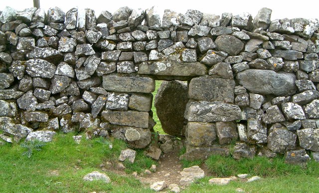
English: Sheep creep near the Roman camp on Mastiles lane. Drystone walls may have by openings for livestock. A traditional opening is the "sheep-creep", a square opening made in the lower part of the wall, and filled in on top. Some are made so that the upper layers of stone can be removed to create an opening large enough for cattle to pass through. These larger openings are called "cow-creeps". |
||
Date | |||
Source | From geograph.org.uk | ||
Author | Martyn Gorman | ||
Permission (Reusing this file) |
This file is licensed under the Creative Commons Attribution-Share Alike 2.0 Generic license. Attribution: Martyn Gorman
|
||
Attribution (required by the license) InfoField | Martyn Gorman / Sheep creep near the Roman camp on Mastiles lane / | ||
InfoField | Martyn Gorman / Sheep creep near the Roman camp on Mastiles lane |
Object location | 54° 05′ 06″ N, 2° 08′ 06″ W | View this and other nearby images on: OpenStreetMap | 54.084900; -2.135000 |
---|
File history
Click on a date/time to view the file as it appeared at that time.
Date/Time | Thumbnail | Dimensions | User | Comment | |
---|---|---|---|---|---|
current | 15:23, 31 January 2010 | 640 × 387 (118 KB) | GeographBot (talk | contribs) | == {{int:filedesc}} == {{Information |description={{en|1=Sheep creep near the Roman camp on Mastiles lane. Drystone walls may have by openings for livestock. A traditional opening is the "sheep-creep", a square opening made in the lower part of the wall, |
You cannot overwrite this file.
File usage on Commons
There are no pages that use this file.
Metadata
This file contains additional information such as Exif metadata which may have been added by the digital camera, scanner, or software program used to create or digitize it. If the file has been modified from its original state, some details such as the timestamp may not fully reflect those of the original file. The timestamp is only as accurate as the clock in the camera, and it may be completely wrong.
Camera manufacturer | FUJIFILM |
---|---|
Camera model | FinePix F601 ZOOM |
Exposure time | 1/340 sec (0.0029411764705882) |
F-number | f/4 |
ISO speed rating | 200 |
Date and time of data generation | 10:58, 11 June 2005 |
Lens focal length | 9.4 mm |
Orientation | 0 |
Horizontal resolution | 72 dpi |
Vertical resolution | 72 dpi |
Software used | Digital Camera FinePix F601 ZOOM Ver2.00 |
File change date and time | 10:58, 11 June 2005 |
Y and C positioning | Co-sited |
Exposure Program | Normal program |
Exif version | 2.2 |
Date and time of digitizing | 10:58, 11 June 2005 |
Image compression mode | 3.2 |
APEX shutter speed | 8.4 |
APEX aperture | 4 |
APEX brightness | 6.76 |
APEX exposure bias | 0 |
Maximum land aperture | 3 APEX (f/2.83) |
Metering mode | Pattern |
Light source | Unknown |
Flash | Flash fired, compulsory flash firing |
Color space | Uncalibrated |
Focal plane X resolution | 3,704 |
Focal plane Y resolution | 3,704 |
Focal plane resolution unit | 3 |
Sensing method | One-chip color area sensor |
Exposure mode | Auto exposure |
White balance | Auto white balance |
Scene capture type | Standard |
Sharpness | 3 |
Subject distance range | Unknown |
Hidden categories:
- CC-BY-SA-2.0
- Images from Geograph Britain and Ireland
- Images from Geograph Britain and Ireland missing SDC coordinates of the point of view
- Images from Geograph Britain and Ireland missing SDC MIME type
- Information field template with formatting
- Files with coordinates missing SDC location of creation
- United Kingdom photographs taken on 2005-06-11
- Pages with maps