File:Schlegeisspeicher Panorama vom Berliner Höhenweg Nr 526 in den Zillertaler Alpen.jpg
Original file (5,465 × 3,080 pixels, file size: 10.9 MB, MIME type: image/jpeg)
Captions
DescriptionSchlegeisspeicher Panorama vom Berliner Höhenweg Nr 526 in den Zillertaler Alpen.jpg |
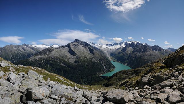
Deutsch: Panorama um 15°° Uhr Nachmittags. Vom Berliner Höhenweg auf 2.493 Meter sieht man auf den Schlegeisspeicher in den Zillertaler Alpen. Die Wegroute liegt zwischen der Olpererhütte und dem Friesenberghaus.
|
|||
Date | ||||
Source | Own work | |||
Author | böhringer friedrich | |||
Permission (Reusing this file) |
I, the copyright holder of this work, hereby publish it under the following license: This file is licensed under the Creative Commons Attribution-Share Alike 2.5 Generic license.
|
|||
Other versions |
|
Camera location | 47° 03′ 19.74″ N, 11° 41′ 39.18″ E | View this and other nearby images on: OpenStreetMap | 47.055483; 11.694217 |
---|
This Photo was taken by Böhringer Friedrich.
|
Feel free to use my photos, but please mention me as the author and if you want send me a message. or (rufre@lenz-nenning.at)
|
Annotations InfoField | This image is annotated: View the annotations at Commons |
Schlegeisscharte
Hoher Weißzint 3.370m, Italien, Entfernung ca.9km; Südost
Hochfeiler 3.510m, Italien, Entfernung ca.8km; Süd
Hochfernerspitze 3.463m, Italien, Entfernung ca.7km; Süd
Vordere Weißspitze 3.276m, Italien, Entfernung ca.7km; Süd
Rotes Beil 2.949m, Italien, Entfernung ca.10km; Süd
Wurmaulspitz 3.022m, Italien, Entfernung ca.14km; Süd
Hochsteller 3.097m, Entfernung ca.5km; Süd
Breitnock 3.215m
Nevessattel 3.029m
Groß Möseler 3.478m
Möselekopf 3.389m, Italien, Entfernung ca.9km; Südost
Großer Greiner 3.201m, Entfernung ca.5km; Südost
Rotbachlspitze 2.895m
Schlegeisspeicher 1.782m
Kleiner Igent 2.840m
Großer Igent 2.917m
Ochsner 3.107m, Entfernung ca.9km; Ost
Kleiner Mörchner 3.197m; Österreich, Entfernung ca.13km, Ost
Großer Mörchner 3.283m; Italien, Entfernung ca.13km, Ost
Richtung Olpererhütte
Richtung Friesenberghaus
Hintere Weißspitze 3.395m, Italien, Entfernung ca.7km; Süd
This image has been assessed using the Quality image guidelines and is considered a Quality image.
العربية ∙ جازايرية ∙ беларуская ∙ беларуская (тарашкевіца) ∙ български ∙ বাংলা ∙ català ∙ čeština ∙ Cymraeg ∙ Deutsch ∙ Schweizer Hochdeutsch ∙ Zazaki ∙ Ελληνικά ∙ English ∙ Esperanto ∙ español ∙ eesti ∙ euskara ∙ فارسی ∙ suomi ∙ français ∙ galego ∙ עברית ∙ हिन्दी ∙ hrvatski ∙ magyar ∙ հայերեն ∙ Bahasa Indonesia ∙ italiano ∙ 日本語 ∙ Jawa ∙ ქართული ∙ 한국어 ∙ kurdî ∙ Lëtzebuergesch ∙ lietuvių ∙ македонски ∙ മലയാളം ∙ मराठी ∙ Bahasa Melayu ∙ Nederlands ∙ Norfuk / Pitkern ∙ polski ∙ português ∙ português do Brasil ∙ rumantsch ∙ română ∙ русский ∙ sicilianu ∙ slovenčina ∙ slovenščina ∙ shqip ∙ српски / srpski ∙ svenska ∙ தமிழ் ∙ తెలుగు ∙ ไทย ∙ Tagalog ∙ Türkçe ∙ toki pona ∙ українська ∙ vèneto ∙ Tiếng Việt ∙ 中文 ∙ 中文(简体) ∙ 中文(繁體) ∙ +/− |
File history
Click on a date/time to view the file as it appeared at that time.
Date/Time | Thumbnail | Dimensions | User | Comment | |
---|---|---|---|---|---|
current | 21:06, 19 August 2011 | 5,465 × 3,080 (10.9 MB) | Böhringer (talk | contribs) | {{Information |Description= {{de|Panorama um 15°° Uhr Nachmittags. Vom Berliner Höhenweg auf 2.493 Meter sieht man auf den '''Schlegeisspeicher''' in den [[:de:Z |
You cannot overwrite this file.
File usage on Commons
The following 5 pages use this file:
File usage on other wikis
The following other wikis use this file:
- Usage on ceb.wikipedia.org
- Usage on de.wikipedia.org
- Usage on en.wikipedia.org
- Usage on pl.wikipedia.org
- Usage on pl.wikimedia.org
- Usage on pl.wikivoyage.org
- Usage on sv.wikipedia.org
- Usage on www.wikidata.org
- Usage on zh.wikipedia.org
Metadata
This file contains additional information such as Exif metadata which may have been added by the digital camera, scanner, or software program used to create or digitize it. If the file has been modified from its original state, some details such as the timestamp may not fully reflect those of the original file. The timestamp is only as accurate as the clock in the camera, and it may be completely wrong.
Exposure time | 1/400 sec (0.0025) |
---|---|
F-number | f/10 |
Date and time of data generation | 15:40, 11 August 2011 |
Altitude | 2,492.446 meters above sea level |
Orientation | Normal |
Software used | Capture NX 2.2.5 W |
File change date and time | 22:02, 19 August 2011 |
Y and C positioning | Centered |
Exif version | 2.2 |
Date and time of digitizing | 15:40, 11 August 2011 |
DateTimeOriginal subseconds | 00 |
DateTimeDigitized subseconds | 00 |
Color space | Uncalibrated |
North or south latitude | North latitude |
East or west longitude | East longitude |
Structured data
Items portrayed in this file
depicts
some value
11 August 2011
47°3'19.739"N, 11°41'39.181"E
- CC-BY-SA-2.5
- Self-published work
- Images with extracted images
- Files with coordinates missing SDC location of creation
- Photos by Böhringer
- Photos by Böhringer, 2011 Zillertal
- Taken with Nikon D300s
- Images with annotations
- Images with 10+ annotations
- Quality images
- Quality images missing SDC depicts
- Pages with maps