File:Sandstone & shale (Vinton Member, Logan Formation, Lower Mississippian; Hanover Pit, Licking County, Ohio, USA) (40666170823).jpg

Original file (4,000 × 3,000 pixels, file size: 5.85 MB, MIME type: image/jpeg)
Captions
Captions
Summary[edit]
_(40666170823).jpg&action=edit§ion=1)
| Description |
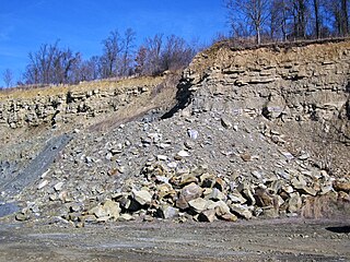
Sandstone and shale in the Mississippian of Ohio, USA. The Bowerston Shale Company was founded in the fall of 1929 by Samuel D. Milliken. They have brick manufacturing plants in Bowerston, Ohio and Hanover, Ohio. The Hanover plant makes bricks using rocks derived from two quarries that I know of - the Hanover Pit and the Frazeysburg Pit. I have visited both, with kind permission of the Bowerston company. The Hanover Pit targets shales of the Vinton Member (Logan Formation), a Lower Mississippian mixed siliciclastics unit. The Frazeysburg Pit targets shales of the Pottsville Group, a Pennsylvanian-aged succession of interbedded shales, limestones, sandstones, coals, flint, clay, and minor ironstone. The shales are excavated at both pits and left in piles in the quarries to weather. Limestones, sandstones, and coals are excluded from the shale piles. Shale material is eventually trucked to the Hanover Plant, where it is processed into bricks. The outcrop in the background is the active highwall at the Hanover Pit. A sandstone-dominated section occurs above - this is overburden. The lower part of the section (here covered by loose material) consists of shales that are the target rocks for the brick plant. The shale horizon is called "Middle Blue". Stratigraphy: Vinton Member, upper Logan Formation, Osagean Stage, upper Lower Mississippian Locality: active quarry, Hanover Pit (Bowerston Shale Company), south of Route 16 & Rock Haven Road, southeast of the town of Hanover, far-eastern Licking County, east-central Ohio, USA (40° 04’ 15.43” North latitude, 82° 14' 44.02" West longitude) |
| Date | |
| Source | Sandstone & shale (Vinton Member, Logan Formation, Lower Mississippian; Hanover Pit, Licking County, Ohio, USA) |
| Author | James St. John |
Licensing[edit]
_(40666170823).jpg&action=edit§ion=2)
- You are free:
- to share – to copy, distribute and transmit the work
- to remix – to adapt the work
- Under the following conditions:
- attribution – You must give appropriate credit, provide a link to the license, and indicate if changes were made. You may do so in any reasonable manner, but not in any way that suggests the licensor endorses you or your use.
| This image was originally posted to Flickr by James St. John at https://flickr.com/photos/47445767@N05/40666170823. It was reviewed on 10 October 2019 by FlickreviewR 2 and was confirmed to be licensed under the terms of the cc-by-2.0. |
File history
Click on a date/time to view the file as it appeared at that time.
| Date/Time | Thumbnail | Dimensions | User | Comment | |
|---|---|---|---|---|---|
| current | 02:25, 10 October 2019 | | 4,000 × 3,000 (5.85 MB) | Ser Amantio di Nicolao (talk | contribs) | Transferred from Flickr via #flickr2commons |
You cannot overwrite this file.
File usage on Commons
There are no pages that use this file.
_(40666170823).jpg&oldid=703043260)