File:San jose ca 1994.jpg

Original file (639 × 639 pixels, file size: 186 KB, MIME type: image/jpeg)
Captions
Captions
Summary[edit]
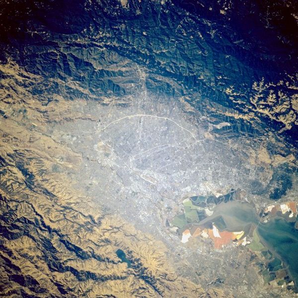
original description from en.WP:
"San Jose occupies roughly the center of the picture, extending to the upper left. Starting at about the top of the urban area and moving clockwise to the bottom of the central urban area (above the colorful salt evaporation ponds at the southern end of the San Francisco Bay), the cities of Los Gatos, Saratoga, Cupertino, Mountain View, Sunnyvale, surround San Jose in a semicircle.
Extending down the lower left side are the cities of Milpitas, Fremont, and possibly San Leandro and Hayward. Extending from the right side of the central area begin the Peninsula cities of Palo Alto, East Palo Alto, Los Altos Hills, and Menlo Park.
California State Route 85 is seen as a large arc across the top of the urban area; California State Route 17 crosses 85 vertically at the center top and heads into the Santa Cruz mountains. The Dumbarton Bridge crosses the Bay towards the lower right."
NASA satellite Image by 1994
first publisher to WP: en:User:Darwinek
Licensing[edit]
| This file is in the public domain in the United States because it was solely created by NASA. NASA copyright policy states that "NASA material is not protected by copyright unless noted". (See Template:PD-USGov, NASA copyright policy page or JPL Image Use Policy.) | ||
 |
Warnings:
|
File history
Click on a date/time to view the file as it appeared at that time.
| Date/Time | Thumbnail | Dimensions | User | Comment | |
|---|---|---|---|---|---|
| current | 13:03, 9 December 2005 | | 639 × 639 (186 KB) | Otto Normalverbraucher (talk | contribs) | original description from en.WP: "San Jose occupies roughly the center of the picture, extending to the upper left. Starting at about the top of the urban area and moving clockwise to the bottom of the central urban area (above the colorful salt evaporat |
You cannot overwrite this file.
File usage on Commons
There are no pages that use this file.