File:STS066-89-69 - Image of Taiwan Northern Half.jpg
Jump to navigation
Jump to search

Size of this preview: 600 × 600 pixels. Other resolutions: 240 × 240 pixels | 480 × 480 pixels | 768 × 768 pixels | 1,024 × 1,024 pixels | 2,048 × 2,048 pixels | 5,294 × 5,294 pixels.
Original file (5,294 × 5,294 pixels, file size: 5.68 MB, MIME type: image/jpeg)
Captions
Captions
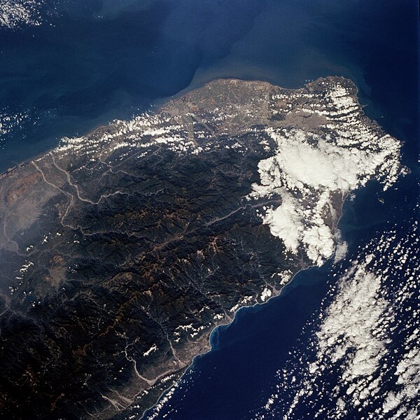
North Half of Taiwan as seen from STS-66
Summary[edit]
| Description |
English: The island of Taiwan (National Republic of China) has a population of more than 21 million in an area the size of Switzerland; this photograph shows the northern half of the island. Most of the inhabitants live along the plains that extend along the entire west coast. Ti-pei, the capital with a population of almost 3 million, is located near the northern tip of the island. The small scale of the photograph and the gross resolution allow only identification of the general location of the urban area at the northern end of the island. Many short rivers that drain east and west arise in the Chungyang Mountains that extend for almost the entire length of the country. The mountains of Taiwan, with some of the central ranges rising to altitudes of more than 10 000 feet (3000 meters), are young and still actively undergoing tectonic movement. Taiwan is bordered on the west by the Taiwan Strait, which separates the country from mainland China (People Republic of China), and on the east by the Pacific Ocean. Taiwan is an amazing economic success story; along with Japan, Hong Kong, South Korea, and Singapore, it is considered to be one of the "Pacific Rim Economic Tigers." |
| Date | |
| Source | JSC Gateway to Astronaut Photography of Earth |
| Author | Earth Science and Remote Sensing Unit, Lyndon B. Johnson Space Center |
| Mission | STS066 |
| Roll | 89 |
| Frame | 69 |
| Geographic area | North Half of Taiwan |
| Features | Mountains, cities, rivers, haze |
| Cloud percentage | 30% |
| Altitude | 162 nautical miles (300 km) |
| Look angle | 25° |
| Look direction | NW |
| Sun Azimuth | 154° |
| Sun Elevation | 47° |
| Camera | Hasselblad |
| Film | 5046: Kodak, natural color positive, Lumiere 100/5046, ASA 100, standard base |
| Focal length | 100 |
| Camera location | | View this and other nearby images on: OpenStreetMap |
|---|
| Object location | | View this and other nearby images on: OpenStreetMap |
|---|
This image or video was catalogued by Johnson Space Center of the United States National Aeronautics and Space Administration (NASA) under Photo ID: STS066-89-69. This tag does not indicate the copyright status of the attached work. A normal copyright tag is still required. See Commons:Licensing. Other languages:
|
Licensing[edit]
| This file is in the public domain in the United States because it was solely created by NASA. NASA copyright policy states that "NASA material is not protected by copyright unless noted". (See Template:PD-USGov, NASA copyright policy page or JPL Image Use Policy.) | ||
 |
Warnings:
|
File history
Click on a date/time to view the file as it appeared at that time.
| Date/Time | Thumbnail | Dimensions | User | Comment | |
|---|---|---|---|---|---|
| current | 10:58, 20 February 2024 | | 5,294 × 5,294 (5.68 MB) | Askeuhd (talk | contribs) | Improved quality and resolution |
| 07:23, 15 November 2004 |  | 640 × 640 (144 KB) | Wdshu (talk | contribs) | {{PD-USGov-NASA}} |
You cannot overwrite this file.
File usage on Commons
The following 3 pages use this file:
File usage on other wikis
The following other wikis use this file:
- Usage on zh.wikibooks.org
- Usage on zh.wikinews.org