File:Reykjavik, Iceland ESA396347.jpg

Original file (10,980 × 10,980 pixels, file size: 6.52 MB, MIME type: image/jpeg)
Captions
Captions
Summary[edit]
| Warning | The original file is very high-resolution. It might not load properly or could cause your browser to freeze when opened at full size. |
|---|
| Description |
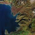
English: The Copernicus Sentinel-2A satellite takes us over the capital of Iceland, Reykjavik. As a volcanic island famous for its volcanoes, glaciers, lakes, lava and hot springs, Iceland attracts tourists all year round with its vast array of natural wonders.
Click on the box in the lower-right corner to view this image at its full 10 m resolution directly in your browser. This true colour image shows us the small city of Reykjavik, home to around 120 000 people, and seen in the lower central part of the image. The port town of Akranes, 20 km north of the capital, is also shown in grey in the centre of the image. In between the two lies Mount Esja, standing just over 900 m tall, and providing a dramatic backdrop to the capital. In the upper left part of the image, ‘kettle holes’ are visible as small dark green dots scattered across the reddish brown area. Kettle holes are formed when blocks of ice break away from glaciers and then become buried in outwash. When these buried blocks of glacier ice melt away they leave behind holes, which become filled with water and turn into kettle hole lakes. They are often found in areas that were covered in ice during the last ice age, which ended around 12 000 years ago. Kettle holes are common in Michigan in the United States, as well as in parts of Germany, Austria and the UK. The Sentinel-2 mission is tasked with monitoring our changing lands. Designed specifically to monitor vegetation, it can also detect differences in sparsely vegetated areas, as well as the mineral composition of soil, as found in Iceland. This image, which was captured on 1 November 2017, is also featured on theEarth from Space video programme. |
| Date | |
| Source | http://www.esa.int/spaceinimages/Images/2018/07/Reykjavik_Iceland |
| Author | European Space Agency |
| Permission (Reusing this file) |
contains modified Copernicus Sentinel data (2017), processed by ESA ,CC BY-SA 3.0 IGO |
| Other versions |
|
| Title | Reykjavik, Iceland |
| System | Copernicus |
| Set | Earth observation image of the week |
| Location | Iceland |
| Mission | Sentinel-2 |
| Activity | Observing the Earth |
Licensing[edit]
- You are free:
- to share – to copy, distribute and transmit the work
- to remix – to adapt the work
- Under the following conditions:
- attribution – You must give appropriate credit, provide a link to the license, and indicate if changes were made. You may do so in any reasonable manner, but not in any way that suggests the licensor endorses you or your use.
- share alike – If you remix, transform, or build upon the material, you must distribute your contributions under the same or compatible license as the original.

|
This image contains data from a satellite in the Copernicus Programme, such as Sentinel-1, Sentinel-2 or Sentinel-3. Attribution is required when using this image.
Attribution: Contains modified Copernicus Sentinel data {{{year}}}
The use of Copernicus Sentinel Data is regulated under EU law (Commission Delegated Regulation (EU) No 1159/2013 and Regulation (EU) No 377/2014). Relevant excerpts:
Free access shall be given to GMES dedicated data [...] made available through GMES dissemination platforms [...].
Access to GMES dedicated data [...] shall be given for the purpose of the following use in so far as it is lawful:
GMES dedicated data [...] may be used worldwide without limitations in time.
GMES dedicated data and GMES service information are provided to users without any express or implied warranty, including as regards quality and suitability for any purpose. |
| Annotations | This image is annotated: View the annotations at Commons |
File history
Click on a date/time to view the file as it appeared at that time.
| Date/Time | Thumbnail | Dimensions | User | Comment | |
|---|---|---|---|---|---|
| current | 16:00, 6 July 2018 | | 10,980 × 10,980 (6.52 MB) | Fæ (talk | contribs) | European Space Agency, Id 396347, http://www.esa.int/spaceinimages/Images/2018/07/Reykjavik_Iceland, User:Fæ/Project_list/ESA |
You cannot overwrite this file.
File usage on Commons
The following page uses this file:
Metadata
- Photos of Iceland by Sentinel-2
- Satellite pictures of Iceland
- Reykjanes peninsula
- Satellite pictures of Reykjanes
- Aerial photographs of Reykjavík
- Hvalfjörður
- Akranes
- Akrafjall
- Hafnarfjall
- Borgarfjörður
- Skarðsheiði
- Vesturland
- Snæfellsnes
- Mýrar (Borgarfjörður)
- Hnappadalur
- Hítardalur
- Ok (volcano)
- Esjan
- 2018 in Iceland
- Satellite pictures of Reykjavík