File:Red River Trails Locator Map.PNG
Jump to navigation
Jump to search
No higher resolution available.
Red_River_Trails_Locator_Map.PNG (435 × 600 pixels, file size: 32 KB, MIME type: image/png)
Captions
Captions
Add a one-line explanation of what this file represents
Summary[edit]
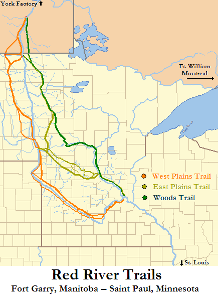
| Description | Locator Map of Red River Trails, Canada and United States |
| Date | |
| Source | Base maps of North Dakota, South Dakota, Minnesota, Iowa, Wisconsin, and Michigan taken from US Census website [1] and modified by User:Ruhrfisch; separate state maps combined and further modified by User:Kablammo, using maps and information from Gilman, Rhoda R., Gilman, Carolyn, & Stultz, Deborah M. Stultz, (1979). The Red River Trails: Oxcart Routes Between St. Paul and the Selkirk Settlement, 1820-1870. St. Paul: Minnesota Historical Society Press. ISBN 0-8735-1133-6; Lass, William E. (1980). Minnesota’s Boundary with Canada. St. Paul: Minnesota Historical Society Press. ISBN 0-8735-1153-0; Kelsey, Vera (1951). Red River Runs North! New York: Harper & Brothers; and Morse, Eric W. (1969). Fur Trade Canoe Routes of Canada / Then and Now. Minocqua, WI: NorthWord Press. ISBN 1-5597-1045-4. |
| Author | US Census, Ruhrfisch, Kablammo |
| Permission (Reusing this file) |
US Census / US Government work in public domain, modifications by Ruhrfisch licensed under the GNU Free Documentation License; further modifications by Kablammo under same license. |
| Other versions | none, other than base maps by Ruhrfish |
Licensing[edit]
Kablammo, the copyright holder of this work, hereby publishes it under the following licenses:

|
Permission is granted to copy, distribute and/or modify this document under the terms of the GNU Free Documentation License, Version 1.2 or any later version published by the Free Software Foundation; with no Invariant Sections, no Front-Cover Texts, and no Back-Cover Texts. A copy of the license is included in the section entitled GNU Free Documentation License. |
| This file is licensed under the Creative Commons Attribution-Share Alike 3.0 Unported license. | ||
| Attribution: Kablammo | ||
| ||
| This licensing tag was added to this file as part of the GFDL licensing update. |
This file is licensed under the Creative Commons Attribution-Share Alike 2.5 Generic license.
Attribution: Kablammo
- You are free:
- to share – to copy, distribute and transmit the work
- to remix – to adapt the work
- Under the following conditions:
- attribution – You must give appropriate credit, provide a link to the license, and indicate if changes were made. You may do so in any reasonable manner, but not in any way that suggests the licensor endorses you or your use.
- share alike – If you remix, transform, or build upon the material, you must distribute your contributions under the same or compatible license as the original.
You may select the license of your choice.
, after
Ruhrfisch, the copyright holder of this work, hereby publishes it under the following licenses:
|
|
Permission is granted to copy, distribute and/or modify this document under the terms of the GNU Free Documentation License, Version 1.2 or any later version published by the Free Software Foundation; with no Invariant Sections, no Front-Cover Texts, and no Back-Cover Texts. A copy of the license is included in the section entitled GNU Free Documentation License. |
| This file is licensed under the Creative Commons Attribution-Share Alike 3.0 Unported license. | ||
| Attribution: Ruhrfisch | ||
| ||
| This licensing tag was added to this file as part of the GFDL licensing update. |
This file is licensed under the Creative Commons Attribution-Share Alike 2.5 Generic license.
Attribution: Ruhrfisch
- You are free:
- to share – to copy, distribute and transmit the work
- to remix – to adapt the work
- Under the following conditions:
- attribution – You must give appropriate credit, provide a link to the license, and indicate if changes were made. You may do so in any reasonable manner, but not in any way that suggests the licensor endorses you or your use.
- share alike – If you remix, transform, or build upon the material, you must distribute your contributions under the same or compatible license as the original.
You may select the license of your choice.
and
This image or file is a work of a United States Census Bureau employee, taken or made as part of that person's official duties. As a work of the U.S. federal government, the image is in the public domain.
|
 |
File history
Click on a date/time to view the file as it appeared at that time.
| Date/Time | Thumbnail | Dimensions | User | Comment | |
|---|---|---|---|---|---|
| current | 17:55, 3 February 2008 | | 435 × 600 (32 KB) | Kablammo (talk | contribs) | == Summary == {{Information| |Description= Locator Map of Red River Trails, Canada and United States |Source= base maps of North Dakota, South Dakota, Minnesota, Iowa, Wisconsine, and Michigan taken from US Census website [http:/ |
You cannot overwrite this file.
File usage on Commons
There are no pages that use this file.