File:Rawskie.png
Jump to navigation
Jump to search

Size of this preview: 609 × 600 pixels. Other resolutions: 244 × 240 pixels | 487 × 480 pixels | 780 × 768 pixels | 1,040 × 1,024 pixels | 2,079 × 2,048 pixels | 3,118 × 3,071 pixels.
Original file (3,118 × 3,071 pixels, file size: 995 KB, MIME type: image/png)
Captions
Captions
Add a one-line explanation of what this file represents
Summary[edit]
| Description |
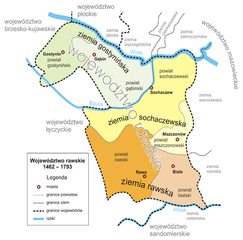
Polski: Podział województwa rawskiego na powiaty English: Rawa Voivodship |
| Date | |
| Source | Own work |
| Author | Fjl |
|
Licensing[edit]

|
Permission is granted to copy, distribute and/or modify this document under the terms of the GNU Free Documentation License, Version 1.2 or any later version published by the Free Software Foundation; with no Invariant Sections, no Front-Cover Texts, and no Back-Cover Texts. A copy of the license is included in the section entitled GNU Free Documentation License. |
| This file is licensed under the Creative Commons Attribution-Share Alike 3.0 Unported license. | ||
| ||
| This licensing tag was added to this file as part of the GFDL licensing update. |
File history
Click on a date/time to view the file as it appeared at that time.
| Date/Time | Thumbnail | Dimensions | User | Comment | |
|---|---|---|---|---|---|
| current | 09:45, 26 July 2005 | | 3,118 × 3,071 (995 KB) | Fjl (talk | contribs) | {{GFDL}} w:Rawa Voivodship Category:Historical maps of Poland |
| 13:19, 20 July 2005 |  | 4,311 × 3,071 (1,021 KB) | Fjl (talk | contribs) | {{GFDL}} w:Rawa Voivodship Category:Historical maps of Poland | |
| 11:58, 20 July 2005 |  | 3,130 × 3,071 (991 KB) | Fjl (talk | contribs) | {{GFDL}} w:Rawa Voivodship Category:Historical maps of Poland | |
| 13:59, 15 July 2005 |  | 3,130 × 3,071 (959 KB) | Fjl (talk | contribs) | {{GFDL}} w:Rawa Voivodship Category:Historical maps of Poland | |
| 16:41, 27 June 2005 |  | 2,126 × 2,185 (630 KB) | Fjl (talk | contribs) | {{GFDL}} w:Rawa Voivodship | |
| 16:12, 27 June 2005 |  | 2,126 × 2,185 (626 KB) | Fjl (talk | contribs) | {{GFDL}} w:Rawa Voivodship | |
| 15:42, 27 June 2005 |  | 2,126 × 2,185 (591 KB) | Fjl (talk | contribs) | {{GFDL}} w:Rawa Voivodship | |
| 15:35, 27 June 2005 |  | 2,000 × 2,077 (585 KB) | Fjl (talk | contribs) | {{GFDL}} w:Rawa Voivodship | |
| 12:09, 27 June 2005 |  | 1,616 × 1,658 (367 KB) | Fjl (talk | contribs) | {{GFDL}} w:Rawa Voivodship |
You cannot overwrite this file.
File usage on Commons
The following page uses this file:
File usage on other wikis
The following other wikis use this file:
- Usage on en.wikipedia.org
- Usage on eo.wikipedia.org
- Usage on es.wikipedia.org
- Usage on fr.wikipedia.org
- Usage on id.wikipedia.org
- Usage on pl.wikipedia.org
- Biała Rawska
- Województwo rawskie
- Dyskusja pliku:Rawskie.png
- Biała Rawska (gmina)
- Ziemia sochaczewska
- Wikiprojekt:Projekt Grafiki/Jak wykonać doskonałą mapę
- Wikipedia:Propozycje do Ilustracji na Medal/Rawskie.png/weryfikacja
- Wikipedia:Ilustracje na Medal/rysunki i animacje
- Szablon:Ilustracja na medal/2011-08-27
- Szablon:Ilustracja na medal/2012-11-05
- Szablon:Ilustracja na medal/2013-12-14
- Wikipedysta:The Polish/Nieużywane szablony/Ilustracja na medal/1-500
- Wikipedysta:The Polish/Nieużywane szablony/Ilustracja na medal/501-1000
- Wikipedysta:The Polish/Nieużywane szablony/Ilustracja na medal/1001-1500
- Ziemia gostynińska
- Ziemia rawska
- Usage on pl.wikivoyage.org
- Usage on pt.wikipedia.org
- Usage on ru.wikipedia.org
- Usage on zh.wikipedia.org