File:RER C.svg
Jump to navigation
Jump to search

Size of this PNG preview of this SVG file: 298 × 599 pixels. Other resolutions: 119 × 240 pixels | 239 × 480 pixels | 382 × 768 pixels | 510 × 1,024 pixels | 1,019 × 2,048 pixels | 832 × 1,671 pixels.
Original file (SVG file, nominally 832 × 1,671 pixels, file size: 256 KB)
Captions
Captions
Add a one-line explanation of what this file represents
| Description |
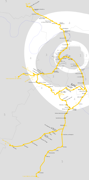
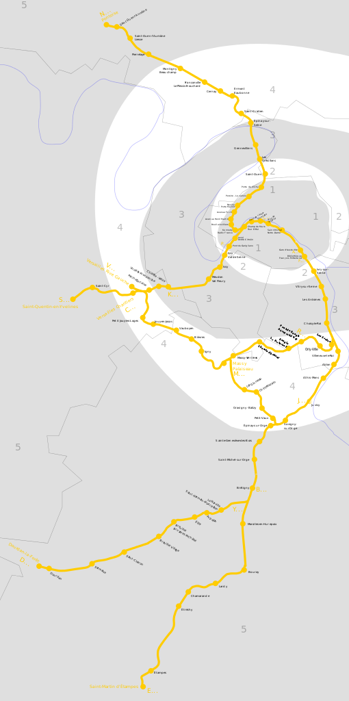
Map of Île de France's RER C line |
||||||||
| Date |
June 19th, 2006 |
||||||||
| Source |
Données géographiques du domaine public |
||||||||
| Author | Benoit Mortgat (User page/Page utilisateur) | ||||||||
| Permission (Reusing this file) |
I, the copyright holder of this work, hereby publish it under the following licenses:
This file is licensed under the Creative Commons Attribution-Share Alike 2.5 Generic, 2.0 Generic and 1.0 Generic license.
You may select the license of your choice. |
||||||||
| Other versions |
 |

File history
Click on a date/time to view the file as it appeared at that time.
| Date/Time | Thumbnail | Dimensions | User | Comment | |
|---|---|---|---|---|---|
| current | 14:18, 5 August 2011 | | 832 × 1,671 (256 KB) | Gonioul (talk | contribs) | resync with Paris_RER.svg |
| 02:16, 7 June 2011 |  | 2,976 × 4,209 (381 KB) | Gonioul (talk | contribs) | lighter zones | |
| 03:25, 25 December 2008 |  | 2,976 × 4,209 (374 KB) | Gonioul (talk | contribs) | zoom test | |
| 17:51, 23 September 2007 |  | 700 × 800 (373 KB) | Gonioul (talk | contribs) | zone 7 -> 6 till 1st july, little recentering | |
| 03:54, 7 March 2007 |  | 1,287 × 1,036 (379 KB) | Gonioul (talk | contribs) | -Argenteuil + Pont du Garigliano | |
| 22:07, 19 June 2006 |  | 1,287 × 1,036 (387 KB) | Pabix (talk | contribs) | This is a plan of Île de France's RER line C. Ceci est un plan de la ligne C de RER en Île de France. Category:Paris RER |
You cannot overwrite this file.
File usage on Commons
The following 4 pages use this file:
File usage on other wikis
The following other wikis use this file:
- Usage on ca.wikipedia.org
- Usage on de.wikipedia.org
- Usage on eo.wikipedia.org
- Usage on es.wikipedia.org
- Usage on fr.wikipedia.org
- Usage on id.wikipedia.org
- Usage on ja.wikipedia.org
- Usage on ru.wikipedia.org
- Usage on zh.wikipedia.org