File:RBR-1627-1668.PNG
From Wikimedia Commons, the free media repository
Jump to navigation
Jump to search

Size of this preview: 570 × 599 pixels. Other resolutions: 228 × 240 pixels | 456 × 480 pixels | 696 × 732 pixels.
Original file (696 × 732 pixels, file size: 38 KB, MIME type: image/png)
File information
Structured data
Captions
Captions
Add a one-line explanation of what this file represents
| DescriptionRBR-1627-1668.PNG |
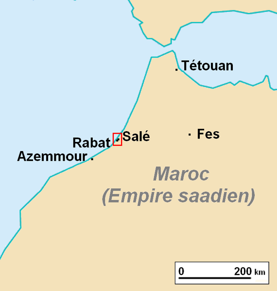
Français : Localisation de la république du Bouregreg (1627-1668) English: Locating the Republic of Salé (1627-1668) in 17th century Morroco |
| Date | |
| Source | Own work |
| Author | Omar-Toons |
| Permission (Reusing this file) |
This file is licensed under the Creative Commons Attribution 1.0 Generic license.
|
| Other versions | Derivative works of this file: RepublicaSale.PNG |
File history
Click on a date/time to view the file as it appeared at that time.
| Date/Time | Thumbnail | Dimensions | User | Comment | |
|---|---|---|---|---|---|
| current | 16:18, 15 May 2010 |  | 696 × 732 (38 KB) | Omar-Toons (talk | contribs) | Oubli d'un petit carré jaune en bas a droite |
| 13:25, 15 May 2010 |  | 696 × 732 (38 KB) | Omar-Toons (talk | contribs) | Reverted to version as of 17:37, 13 May 2010 | |
| 12:12, 15 May 2010 |  | 696 × 732 (39 KB) | Bokpasa (talk | contribs) | False information | |
| 23:32, 14 May 2010 |  | 696 × 732 (38 KB) | Omar-Toons (talk | contribs) | Reverted to version as of 17:37, 13 May 2010 | |
| 21:58, 14 May 2010 |  | 696 × 732 (39 KB) | Bokpasa (talk | contribs) | When you made a map, this map it´s ggood if the name is nor false. | |
| 17:37, 13 May 2010 |  | 696 × 732 (38 KB) | Omar-Toons (talk | contribs) | Erreur de coloriation sur la précédente version | |
| 17:35, 13 May 2010 |  | 696 × 732 (38 KB) | Omar-Toons (talk | contribs) | Vu qu'on parle de la République du Bouregreg, j'ai mis le territoire de l'Empire Saadien comme étant selon la couleur proposée sur la page de discussion de l'article fr:Republique du Bouregreg Category:Maps of Morocco | |
| 17:25, 13 May 2010 |  | 696 × 732 (38 KB) | Omar-Toons (talk | contribs) | Reverted to version as of 08:51, 12 May 2010 Please discuss the changes before uploading a new map | |
| 12:01, 12 May 2010 |  | 696 × 732 (39 KB) | Bokpasa (talk | contribs) | Correct map: *Ceuta,Melilla and islands part of Spain *Gibraltar *Tangier at this time was part of Portugal later to English *Larache was part of Spain | |
| 08:51, 12 May 2010 |  | 696 × 732 (38 KB) | Omar-Toons (talk | contribs) | {{Information |Description={{fr|1=Localisation de la république du Bouregreg (1627-1668)}} |Source={{own}} |Author=Omar-Toons |Date=2010-05-12 |Permission={{CC-BY}} |other_versions= }} Category:Maps of Morocco |
You cannot overwrite this file.
File usage on Commons
The following 3 pages use this file:
File usage on other wikis
The following other wikis use this file:
- Usage on ast.wikipedia.org
- Usage on ca.wikipedia.org
- Usage on es.wikipedia.org
- Usage on fr.wikipedia.org
- Portail:Maghreb/Sélections d’articles
- Wikipédia:Sélection/Afrique
- Wikipédia:Lumière sur/Juillet 2010
- République du Bouregreg
- Wikipédia:Lumière sur/République du Bouregreg
- Wikipédia:Sélection/Maroc
- Portail:Rabat-Salé
- Wikipédia:Sélection/Rabat-Salé
- Portail:Rabat-Salé/Articles-Images
- Utilisateur:WeshMani/Bac à sable/République du Bouregreg
- Wikipédia:Lumière sur/Septembre 2021
- Usage on he.wikipedia.org
- Usage on pt.wikipedia.org
- Usage on www.wikidata.org
Hidden categories: