File:Pope Francis Travels.svg
Jump to navigation
Jump to search

Size of this PNG preview of this SVG file: 800 × 406 pixels. Other resolutions: 320 × 162 pixels | 640 × 325 pixels | 1,024 × 520 pixels | 1,280 × 650 pixels | 2,560 × 1,300 pixels | 2,754 × 1,398 pixels.
Original file (SVG file, nominally 2,754 × 1,398 pixels, file size: 1.15 MB)
Captions
Captions
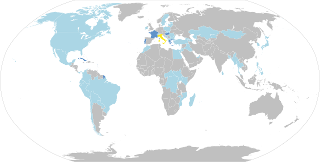
Map showing countries visited by Francis as pope
Summary[edit]
| Description |
Español: Este es un mapa de los países visitados por el Papa Francisco en viajes fuera de Italia.
English: This is a map of Countries visited by Pope Francis outside of Italy.
Deutsch: Karte der Länder, die Papst Franziskus besucht hat
Français : Carte du monde représentant les pays visités par le pape François durant son pontificat.
Polski: Mapa krajów, które odwiedził papież Franciszek |
| Date | |
| Source | Own work |
| Author | Jayarathina, Svenskbygderna (talk) |
| Legend | Vatican City
Italy
5 trips
4 trips
3 trips
2 trips
1 trip
0 trips |
| Base Map | BlankMap-World6.svg: Canuckguy |
| To Edit This Map See | File talk:BlankMap-World6.svg/Documentation |
W3C-validity not checked.
Licensing[edit]
I, the copyright holder of this work, hereby publish it under the following license:
This file is licensed under the Creative Commons Attribution-Share Alike 3.0 Unported license.
- You are free:
- to share – to copy, distribute and transmit the work
- to remix – to adapt the work
- Under the following conditions:
- attribution – You must give appropriate credit, provide a link to the license, and indicate if changes were made. You may do so in any reasonable manner, but not in any way that suggests the licensor endorses you or your use.
- share alike – If you remix, transform, or build upon the material, you must distribute your contributions under the same or compatible license as the original.
File history
Click on a date/time to view the file as it appeared at that time.
| Date/Time | Thumbnail | Dimensions | User | Comment | |
|---|---|---|---|---|---|
| current | 15:18, 12 October 2023 | | 2,754 × 1,398 (1.15 MB) | MisterNox (talk | contribs) | France |
| 16:03, 5 September 2023 |  | 2,754 × 1,398 (1.15 MB) | MisterNox (talk | contribs) | - Western Sahara | |
| 15:54, 3 September 2023 |  | 2,754 × 1,398 (1.15 MB) | MisterNox (talk | contribs) | Mongolia | |
| 11:54, 4 August 2023 |  | 2,754 × 1,398 (1.15 MB) | MisterNox (talk | contribs) | Cuba and Portugal | |
| 17:05, 13 May 2023 |  | 2,754 × 1,398 (1.15 MB) | MisterNox (talk | contribs) | Malta color | |
| 15:59, 13 May 2023 |  | 2,754 × 1,398 (1.15 MB) | MisterNox (talk | contribs) | added missing countries | |
| 15:53, 13 May 2023 |  | 2,754 × 1,398 (1.15 MB) | MisterNox (talk | contribs) | color | |
| 15:48, 13 May 2023 |  | 2,754 × 1,398 (1.15 MB) | MisterNox (talk | contribs) | new map | |
| 07:38, 29 April 2023 |  | 1,151 × 591 (5.79 MB) | KamilosR (talk | contribs) | ++ Hungary | |
| 14:41, 31 January 2023 |  | 1,151 × 591 (5.79 MB) | KamilosR (talk | contribs) | - Catar +Bahrajn, Democratic Republic of the Congo and South Sudan |
You cannot overwrite this file.
File usage on Commons
The following 90 pages use this file:
- User:Adeletron 3030/botgalleries/Sports/2022 November 7-9
- User:Arewicz/Category:Łódź/2015 July 1-10
- User:Arewicz/Category:Łódź/2015 November 21-30
- User:Arewicz/Category:Łódź/2015 September 11-20
- User:Arewicz/Category:Łódź/2016 April 11-20
- User:Arewicz/Category:Łódź/2016 February 1-9
- User:Arewicz/Category:Łódź/2016 February 10-19
- User:Chumwa/OgreBot/Potential transport maps/2019 November 21-30
- User:Chumwa/OgreBot/Transport Maps/2019 November 21-30
- User:Chumwa/OgreBot/Transport Maps/2021 April 11-20
- User:Chumwa/OgreBot/Transport Maps/2021 March 1-10
- User:Chumwa/OgreBot/Transport Maps/2021 May 21-31
- User:Chumwa/OgreBot/Transport Maps/2021 September 11-20
- User:Chumwa/OgreBot/Transport Maps/2022 April 1-10
- User:Chumwa/OgreBot/Transport Maps/2022 December 1-10
- User:Chumwa/OgreBot/Transport Maps/2022 July 21-31
- User:Chumwa/OgreBot/Transport Maps/2022 November 1-10
- User:Chumwa/OgreBot/Transport Maps/2022 October 1-10
- User:Chumwa/OgreBot/Transport Maps/2022 September 11-20
- User:Chumwa/OgreBot/Transport Maps/2023 April 21-30
- User:Chumwa/OgreBot/Transport Maps/2023 August 1-10
- User:Chumwa/OgreBot/Transport Maps/2023 January 21-31
- User:Chumwa/OgreBot/Transport Maps/2023 May 11-20
- User:Chumwa/OgreBot/Transport Maps/2023 October 11-20
- User:Chumwa/OgreBot/Transport Maps/2023 September 1-10
- User:Chumwa/OgreBot/Travel and communication maps/2016 April 11-20
- User:Chumwa/OgreBot/Travel and communication maps/2016 February 1-9
- User:Chumwa/OgreBot/Travel and communication maps/2016 February 10-19
- User:Chumwa/OgreBot/Travel and communication maps/2016 July 21-31
- User:Chumwa/OgreBot/Travel and communication maps/2016 June 21-30
- User:Chumwa/OgreBot/Travel and communication maps/2016 October 1-10
- User:Chumwa/OgreBot/Travel and communication maps/2016 October 21-31
- User:Chumwa/OgreBot/Travel and communication maps/2016 September 21-30
- User:Chumwa/OgreBot/Travel and communication maps/2017 May 1-10
- User:Chumwa/OgreBot/Travel and communication maps/2017 May 11-20
- User:Chumwa/OgreBot/Travel and communication maps/2017 November 21-30
- User:Chumwa/OgreBot/Travel and communication maps/2017 September 1-10
- User:Chumwa/OgreBot/Travel and communication maps/2017 September 11-20
- User:Chumwa/OgreBot/Travel and communication maps/2018 January 11-20
- User:Chumwa/OgreBot/Travel and communication maps/2018 January 21-31
- User:Chumwa/OgreBot/Travel and communication maps/2018 June 21-30
- User:Chumwa/OgreBot/Travel and communication maps/2018 September 1-10
- User:Chumwa/OgreBot/Travel and communication maps/2018 September 21-30
- User:Chumwa/OgreBot/Travel and communication maps/2019 February 1-9
- User:Chumwa/OgreBot/Travel and communication maps/2019 January 21-31
- User:Chumwa/OgreBot/Travel and communication maps/2019 July 11-20
- User:Chumwa/OgreBot/Travel and communication maps/2019 March 21-31
- User:Chumwa/OgreBot/Travel and communication maps/2019 May 1-10
- User:Chumwa/OgreBot/Travel and communication maps/2019 November 21-30
- User:Chumwa/OgreBot/Travel and communication maps/2019 October 11-20
- User:Chumwa/OgreBot/Travel and communication maps/2019 September 1-10
- User:Chumwa/OgreBot/Travel and communication maps/2021 April 11-20
- User:Chumwa/OgreBot/Travel and communication maps/2021 March 1-10
- User:Chumwa/OgreBot/Travel and communication maps/2021 May 21-31
- User:Chumwa/OgreBot/Travel and communication maps/2021 September 11-20
- User:Chumwa/OgreBot/Travel and communication maps/2022 April 1-10
- User:Chumwa/OgreBot/Travel and communication maps/2022 December 1-10
- User:Chumwa/OgreBot/Travel and communication maps/2022 July 21-31
- User:Chumwa/OgreBot/Travel and communication maps/2022 November 1-10
- User:Chumwa/OgreBot/Travel and communication maps/2022 October 1-10
- User:Chumwa/OgreBot/Travel and communication maps/2022 September 11-20
- User:Chumwa/OgreBot/Travel and communication maps/2023 April 21-30
- User:Chumwa/OgreBot/Travel and communication maps/2023 August 1-10
- User:Chumwa/OgreBot/Travel and communication maps/2023 January 21-31
- User:Chumwa/OgreBot/Travel and communication maps/2023 May 11-20
- User:Chumwa/OgreBot/Travel and communication maps/2023 October 11-20
- User:Chumwa/OgreBot/Travel and communication maps/2023 September 1-10
- User:Cybularny/Warsaw/2018 June 16-30
- User:Cybularny/Warsaw/2018 September 1-15
- User:Cybularny/Warsaw/2018 September 16-30
- User:Cybularny/Warsaw/2019 February 1-14
- User:Cybularny/Warsaw/2019 January 16-31
- User:Cybularny/Warsaw/2019 March 16-31
- User:Cybularny/Warsaw/2021 April 16-30
- User:Cybularny/Warsaw/2021 March 1-15
- User:Cybularny/Warsaw/2021 May 16-31
- User:Stolbovsky/Recent uploads/Moscow/2018 June 21/Overflow 1
- User:Stolbovsky/Recent uploads/Moscow/2018 September 1-10
- User:Vuxi/Neue Bilder in Freising/2022 April
- User:Vuxi/Neue Bilder in Freising/2022 December
- User:Vuxi/Neue Bilder in Freising/2022 July
- User:Vuxi/Neue Bilder in Freising/2022 November
- User:Vuxi/Neue Bilder in Freising/2022 October
- User:Vuxi/Neue Bilder in Freising/2022 September
- User:Vuxi/Neue Bilder in Freising/2023 April
- User:Vuxi/Neue Bilder in Freising/2023 August
- User:Vuxi/Neue Bilder in Freising/2023 January
- User:Vuxi/Neue Bilder in Freising/2023 May
- User talk:Svenskbygderna
- File:Pope Francis foreign trips.png
File usage on other wikis
The following other wikis use this file:
- Usage on af.wikipedia.org
- Usage on bg.wikipedia.org
- Usage on bn.wikipedia.org
- Usage on ckb.wikipedia.org
- Usage on cs.wikipedia.org
- Usage on de.wikipedia.org
- Usage on en.wikipedia.org
- Usage on es.wikipedia.org
- Usage on et.wikipedia.org
- Usage on fr.wikipedia.org
- Usage on hr.wikipedia.org
- Usage on id.wikipedia.org
- Usage on it.wikipedia.org
- Viaggi apostolici di papa Francesco
- Progetto:Laboratorio grafico/Immagini da migliorare/Archivio risolte/208
- Utente:Andciao/Sandbox
- Progetto:Laboratorio grafico/Immagini da migliorare/Archivio risolte/214
- Progetto:Laboratorio grafico/Immagini da migliorare/Archivio risolte/215
- Progetto:Laboratorio grafico/Immagini da migliorare/Archivio risolte/216
- Progetto:Laboratorio grafico/Immagini da migliorare/Archivio risolte/217
- Progetto:Laboratorio grafico/Immagini da migliorare/Archivio risolte/219
- Progetto:Laboratorio grafico/Immagini da migliorare/Archivio risolte/230
- Progetto:Laboratorio grafico/Immagini da migliorare/Archivio risolte/232
- Progetto:Laboratorio grafico/Immagini da migliorare/Archivio annullate/9
- Usage on ja.wikipedia.org
- Usage on kk.wikipedia.org
- Usage on la.wikipedia.org
- Usage on ml.wikipedia.org
- Usage on pl.wikipedia.org
- Franciszek (papież)
- Podróże apostolskie Franciszka
- Podróż apostolska Franciszka do Brazylii
- Kategoria:Podróże apostolskie Franciszka
- Podróż apostolska Franciszka do Ziemi Świętej
- Podróż apostolska Franciszka do Korei Południowej
- Podróż apostolska Franciszka do Albanii
- Szablon:Podróże apostolskie Franciszka
- Podróż apostolska Franciszka na Sri Lankę i Filipiny
View more global usage of this file.