File:Political map of Seattle, 1910 (53362717124).jpg
Jump to navigation
Jump to search
Size of this preview: 609 × 599 pixels. Other resolutions: 244 × 240 pixels | 488 × 480 pixels | 780 × 768 pixels | 1,040 × 1,024 pixels | 2,081 × 2,048 pixels | 5,104 × 5,024 pixels.
Original file (5,104 × 5,024 pixels, file size: 10.39 MB, MIME type: image/jpeg)
Captions
Captions
Add a one-line explanation of what this file represents
Summary
[edit]| Description |
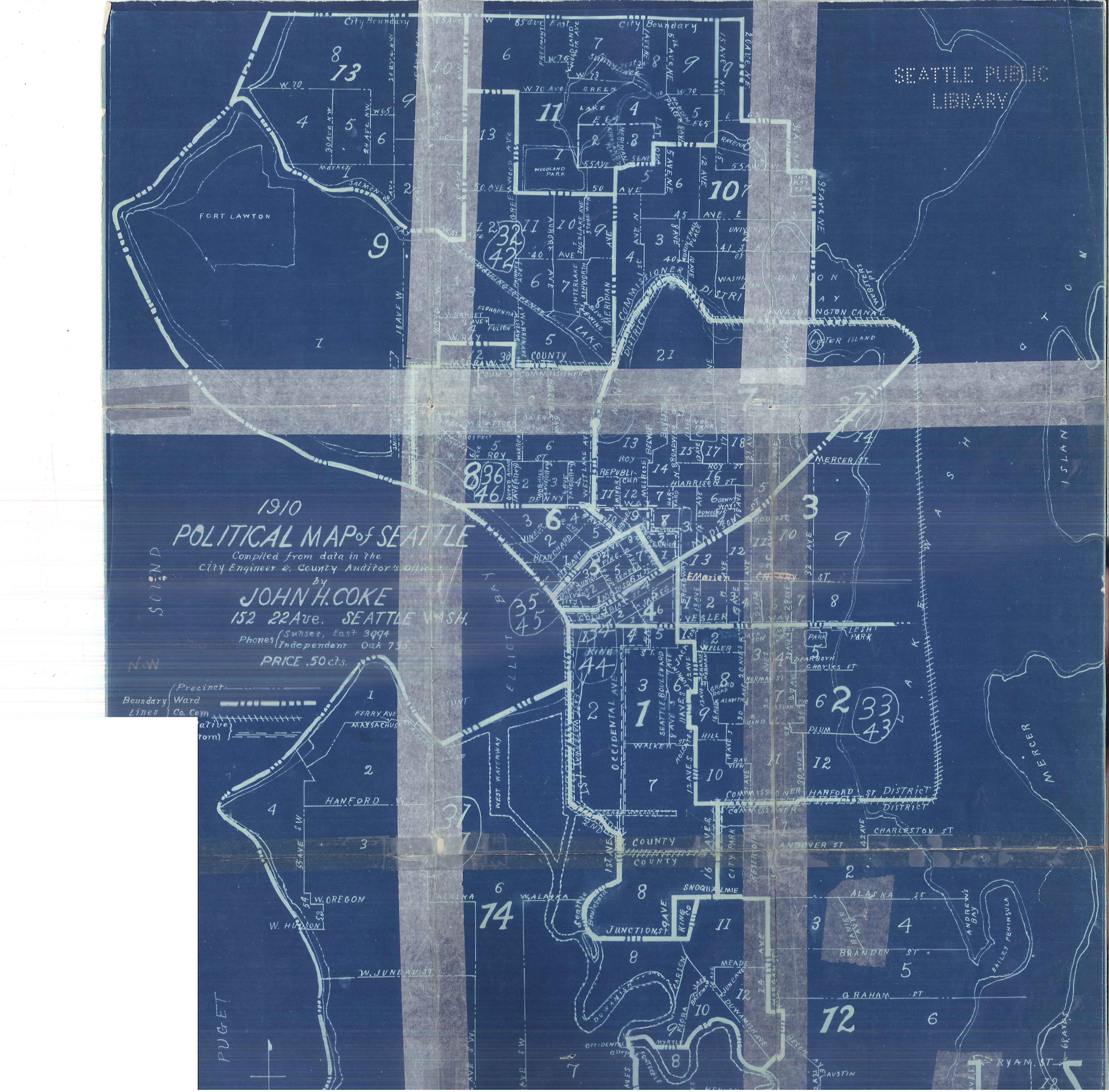
Map 2476, Seattle Municipal Archives. English: Political map of Seattle, Washington, 1910. Shows boundaries of Port and County Commissioner districts; State Representative and Senatorial districts, and City precincts |
||||||||||||||||||||
| Date | |||||||||||||||||||||
| Source |
Political map of Seattle, 1910 This image comes from the Seattle Municipal Archives, via Flickr.
|
||||||||||||||||||||
| Author | Seattle Municipal Archives from Seattle, WA | ||||||||||||||||||||
.jpg)
.jpg&action=edit§ion=1)
Licensing
[edit].jpg&action=edit§ion=2)
This file is licensed under the Creative Commons Attribution 2.0 Generic license.
- You are free:
- to share – to copy, distribute and transmit the work
- to remix – to adapt the work
- Under the following conditions:
- attribution – You must give appropriate credit, provide a link to the license, and indicate if changes were made. You may do so in any reasonable manner, but not in any way that suggests the licensor endorses you or your use.
| This image, originally posted to Flickr, was reviewed on 18 January 2024 by the administrator or reviewer Killarnee, who confirmed that it was available on Flickr under the stated license on that date. |
File history
Click on a date/time to view the file as it appeared at that time.
| Date/Time | Thumbnail | Dimensions | User | Comment | |
|---|---|---|---|---|---|
| current | 05:09, 29 November 2023 | | 5,104 × 5,024 (10.39 MB) | Jmabel (talk | contribs) | high resolution |
| 05:06, 29 November 2023 |  | 700 × 689 (108 KB) | Jmabel (talk | contribs) | Transferred from Flickr via #flickr2commons |
You cannot overwrite this file.
File usage on Commons
There are no pages that use this file.
.jpg&oldid=861045423)