File:Plano provisorio frontera Chile-bolivia 1904.jpg
Jump to navigation
Jump to search

Size of this preview: 221 × 600 pixels. Other resolutions: 88 × 240 pixels | 177 × 480 pixels | 824 × 2,236 pixels.
Original file (824 × 2,236 pixels, file size: 2.45 MB, MIME type: image/jpeg)
Captions
Captions
Add a one-line explanation of what this file represents
Summary[edit]
| Description |
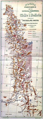
English: Provisional map with the border demarcation between Chile and Bolivia according to the 1904 peace treaty.
Español: "Plano Provisorio de la Línea de Frontera entre Chile i Bolivia establecida en el Tratado de Paz i Amistad celebrado en Santiago de Chile el 20 de octubre de 1904". Escala: 1:1000000 |
|||
| Date | ||||
| Source | Unknown source | |||
| Author | Lit. Suiza, Santiago, Oficina de Límites | |||
| Permission (Reusing this file) |
|
|||
| Other versions |
|

File history
Click on a date/time to view the file as it appeared at that time.
| Date/Time | Thumbnail | Dimensions | User | Comment | |
|---|---|---|---|---|---|
| current | 22:26, 30 April 2006 | 824 × 2,236 (2.45 MB) | Fbaltra (talk | contribs) | Plano Provisorio de la Línea de Frontera entre Chile i Bolivia establecida en el Tratado de Paz i Amistad celebrado en Santiago de Chile el 20 de octubre de 1904 (sic). Leyenda: La línea de color rojo indica los límites con Bolivia. |
You cannot overwrite this file.
File usage on Commons
The following page uses this file:
File usage on other wikis
The following other wikis use this file:
- Usage on de.wikipedia.org
- Usage on es.wikipedia.org
- Usage on pt.wikipedia.org