File:Plan of Memphis, Goedecke, J. Frederick, 1861-1865, TSLA Map Collection, 34768, Tennessee State Library & Archives, Tennessee Virtual Archive.jpg

Original file (9,000 × 7,508 pixels, file size: 5.4 MB, MIME type: image/jpeg)
Captions
Captions
Summary[edit]
| Description |
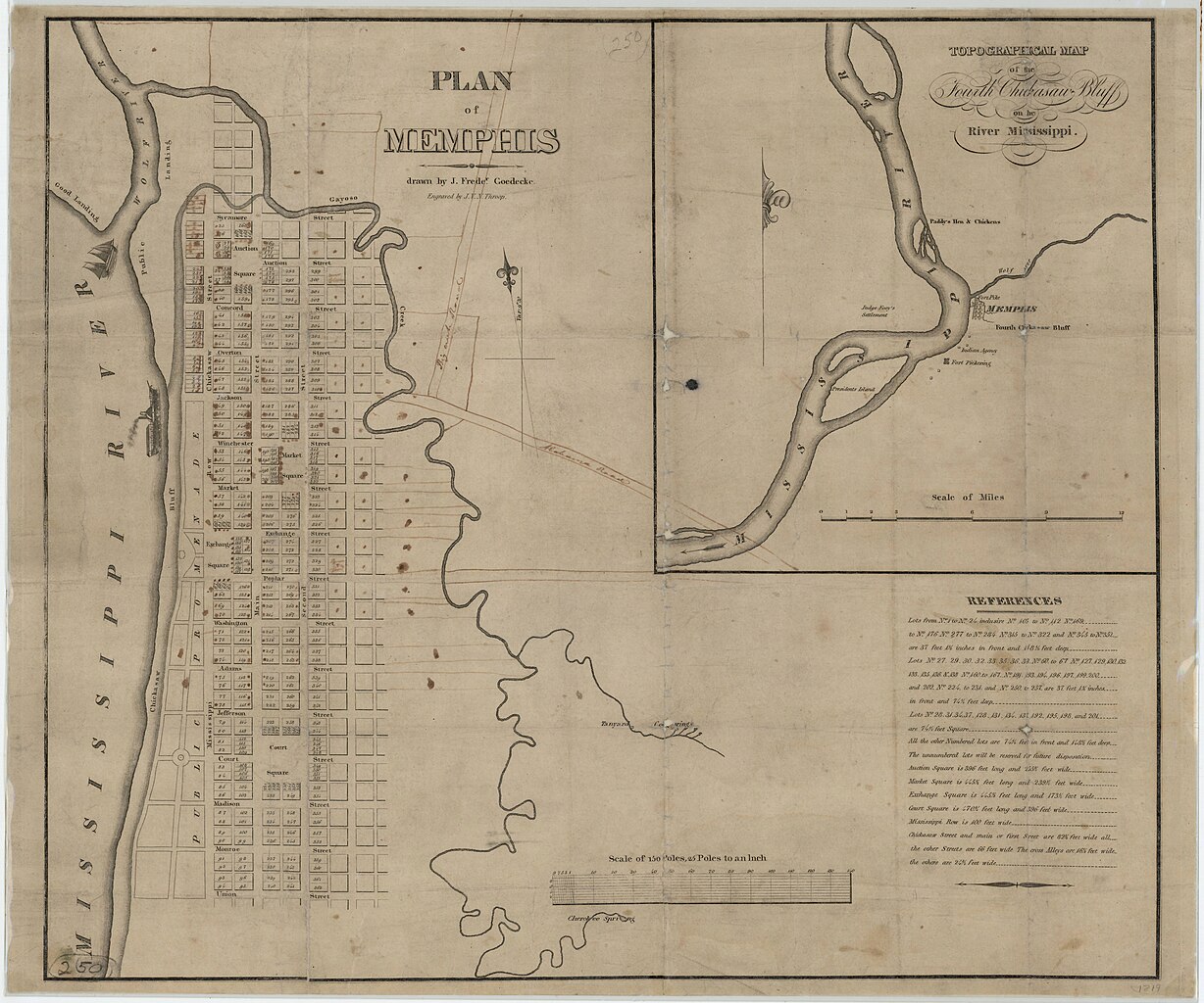
English: "Plan of Memphis," Goedecke, J. Frederick, 1861-1865, TSLA Map Collection, 34768, Tennessee State Library & Archives, Tennessee Virtual Archive |
| Date | |
| Source |
Tennessee Virtual Archive https://teva.contentdm.oclc.org/digital/collection/p15138coll23/id/0/ Title Plan of Memphis Description This map provides a view of the streets of Memphis during the Civil War. The public places and the city blocks are numbered and keyed to the Memphis City Directory. The inset shows the "Topographical Map of the Fourth Chickasaw Bluff on the River Mississippi," with Fort Pickering and President's Island. Historical Note The steamboat era helped Memphis grow until the Civil War, during which both sides sought control of the Mississippi River. After the war, the growth of railroads made Memphis a railroad hub, connecting West Tennesseans to other major cities like New Orleans and Charleston. Creator Goedecke, J. Frederick Engraver Throop, John Peter Van Ness, 1794-approximately 1861 Dimensions 49 x 60 cm Education Tags 4.58; 8.51; Cotton South; Growth of the Republic Place Memphis (Tenn.) Shelby County (Tenn.) Date 1861-1865 Collection Name TSLA Map Collection Subject - LCSH Memphis (Tenn.) Mississippi River Subject - TGM Maps Topographic maps Cliffs Owning Institution Tennessee State Library & Archives ID# 34768 OCLC Original Reference 27735102 Digital Collection Maps at the Tennessee State Library and Archives Media Type Maps Storage location Map 250 Copyright No copyright - United States: http://rightsstatements.org/vocab/NoC-US/1.0/ Ordering Information All images on TeVA are available to download as lower-resolution JPEG files by using the download button on the image page. To order a high-resolution digital reproduction of this item, please see these instructions: http://sos.tn.gov/products/tsla/ordering-images-and-microfilm-digitization. Credit line and copyright information is available here: https://teva.contentdm.oclc.org/customizations/global/pages/about.html. Result with Image Image OCLC number 912909335 IIIF Manifest https://teva.contentdm.oclc.org/iiif/info/p15138coll23/0/manifest.json IIIF Image https://teva.contentdm.oclc.org/digital/iiif/p15138coll23/0/full/full/0/default.jpg https://teva.contentdm.oclc.org/digital/collection/p15138coll23/id/0/ |
| Author | Goedecke |
Licensing[edit]
This work is in the public domain in the United States because it was published (or registered with the U.S. Copyright Office) before January 1, 1929.
Public domain works must be out of copyright in both the United States and in the source country of the work in order to be hosted on the Commons. If the work is not a U.S. work, the file must have an additional copyright tag indicating the copyright status in the source country.
Note: This tag should not be used for sound recordings. |
File history
Click on a date/time to view the file as it appeared at that time.
| Date/Time | Thumbnail | Dimensions | User | Comment | |
|---|---|---|---|---|---|
| current | 20:47, 13 December 2023 | | 9,000 × 7,508 (5.4 MB) | Jengod (talk | contribs) | Uploaded a work by Goedecke from Tennessee Virtual Archive with UploadWizard |
You cannot overwrite this file.
File usage on Commons
There are no pages that use this file.