File:Plan du Fort Condé de la Mobille, marqué en rouge dans l'Etat quil est presentement 1743, avec la partie de l'augementation (i.e. l'augmentation) proposée, marqué en jeaune (i.e. jaune). LOC 2009581264.jpg
Jump to navigation
Jump to search

Size of this preview: 683 × 599 pixels. Other resolutions: 274 × 240 pixels | 547 × 480 pixels | 875 × 768 pixels | 1,167 × 1,024 pixels | 2,333 × 2,048 pixels | 4,162 × 3,653 pixels.
Original file (4,162 × 3,653 pixels, file size: 2 MB, MIME type: image/jpeg)
Captions
Captions
Add a one-line explanation of what this file represents
Summary[edit]
| Description |
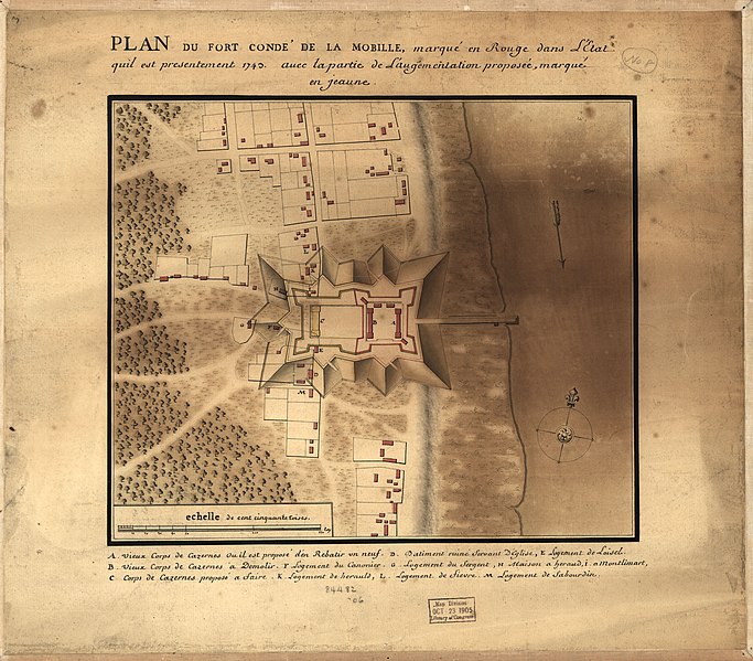
English: Relief shown pictorially and by shading. Shows Mobile and Fort Condé (later renamed Fort Charlotte), Alabama. "Echelle de cent cinquante toises." Pen-and-ink and watercolor (green, brown, red, yellow). "This French plan of Mobile shows proposed improvements for Fort Condé. A legend in the plan indicates proposals to repair, demolish, or construct quarters ..."--Luso-Hispanic World, p. 235. Oriented with north to the upper right. Available also through the Library of Congress Web site as a raster image. Imperfect: Stained along right sheet edge, mounted on cloth backing. LC Luso-Hispanic World, 861 |
||
| Title | Plan du Fort Condé de la Mobille, marqué en rouge dans l'Etat quil est presentement 1743, avec la partie de l'augementation [i.e. l'augmentation] proposée, marqué en jeaune [i.e. jaune]. | ||
| Shelf ID | G3974.M5:2F5 1743 .P5 | ||
| Date | |||
| Source | https://www.loc.gov/item/2009581264/ | ||
| Author | Unknown author | ||
| Permission (Reusing this file) |
|
||
| Other versions |
|
||
| Location | Mobile · United States · Alabama · Fort Charlotte (Mobile) · Fort Charlotte | ||
| Part of | American Memory · Catalog · Geography And Map Division · Cultural Landscapes | ||
| Subject | Maps, Manuscript · Maps · Mobile (Ala.) · Fort Charlotte (Mobile) · United States · Fortification · Early Works To 1800 · Mobile · Fort Charlotte (Mobile, Ala.) · Alabama · Manuscript Maps |


_propos%C3%A9e,_marqu%C3%A9_en_jeaune_(i.e._jaune)._LOC_2009581264.jpg&action=edit§ion=1)
Licensing[edit]
_propos%C3%A9e,_marqu%C3%A9_en_jeaune_(i.e._jaune)._LOC_2009581264.jpg&action=edit§ion=2)
|
This is a faithful photographic reproduction of a two-dimensional, public domain work of art. The work of art itself is in the public domain for the following reason:
The official position taken by the Wikimedia Foundation is that "faithful reproductions of two-dimensional public domain works of art are public domain".
This photographic reproduction is therefore also considered to be in the public domain in the United States. In other jurisdictions, re-use of this content may be restricted; see Reuse of PD-Art photographs for details. | ||||
File history
Click on a date/time to view the file as it appeared at that time.
| Date/Time | Thumbnail | Dimensions | User | Comment | |
|---|---|---|---|---|---|
| current | 13:55, 21 July 2018 | | 4,162 × 3,653 (2 MB) | Fæ (talk | contribs) | LOC Maps https://www.loc.gov/item/2009581264/ #7052 |
You cannot overwrite this file.
File usage on Commons
The following page uses this file:
_proposée,_marqué_en_jeaune_(i.e._jaune)._LOC_2009581264.jpg&oldid=425158252)