File:PittsburghMinedOut1973.png
Jump to navigation
Jump to search

Size of this preview: 315 × 600 pixels. Other resolutions: 126 × 240 pixels | 252 × 480 pixels | 805 × 1,533 pixels.
Original file (805 × 1,533 pixels, file size: 148 KB, MIME type: image/png)
Captions
Captions
Add a one-line explanation of what this file represents
Summary[edit]
| Description |
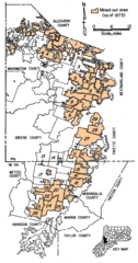
English: Original caption: "Figure 6, - Areas of the Pittsburgh coalbed that have been mined out." The legend originally incorporated into the figure named the mines: "1 Montour No. 4; 2 Mathies; 3 Maple Creek; 4 Westland; 5 Somerset No. 60; 6 Vesta No. 4; 7 Vesta No. 5; 8 Marianna No. 58; 9 Gateway; 10 Mather colleries; 11 Humphrey No. 7; 12 Shannopin; 13 Blacksville No. 2; 14 Blacksville No. 1; 15 Pursglove; 16 Osage No. 3; 17 Federal No. 2; 18 Arkwright; 19 Loveridge; 20 Federal No. 1; 21 Consol No. 93; 22 Consol No. 9; 23 Joanne; 24 Bethlehem No. 41; 25 Bethlehem No. 44; 26 Consol No. 20; 27 Robena; 28 Nemacolin; 29 Crucible; 30 Bethlehem No 51." The mined out areas have been colorized and the key relocated by the uploader, who claims no rights to these modifications. |
| Date | |
| Source | Selected Geologic Factors Affecting Mining of the Pittsburgh Coalbed, United States Bureau of Mines, RI 8093 |
| Author | C. M. McCulloch, W. P. Diamond, B. M. Bench, Maurice Deul |
Licensing[edit]
This image is a work of the Centers for Disease Control and Prevention, part of the United States Department of Health and Human Services, taken or made as part of an employee's official duties. As a work of the U.S. federal government, the image is in the public domain.
|
File history
Click on a date/time to view the file as it appeared at that time.
| Date/Time | Thumbnail | Dimensions | User | Comment | |
|---|---|---|---|---|---|
| current | 21:52, 21 July 2009 | | 805 × 1,533 (148 KB) | Douglas W. Jones (talk | contribs) | {{Information |Description={{en|1=Original caption: "Figure 6, - Areas of the Pittsburgh coalbed that have been mined out." The legend originally incorporated into the figure named the mines: "1 Montour No. 4; 2 Mathies; 3 Maple Creek; 4 Westland; 5 So |
You cannot overwrite this file.
File usage on Commons
The following page uses this file:
File usage on other wikis
The following other wikis use this file:
- Usage on en.wikipedia.org