File:Ph eastern visayas.png
Jump to navigation
Jump to search
No higher resolution available.
Ph_eastern_visayas.png (402 × 580 pixels, file size: 37 KB, MIME type: image/png)
Captions
Captions
Add a one-line explanation of what this file represents

|
This image could be re-created using vector graphics as an SVG file. This has several advantages; see Commons:Media for cleanup for more information. If an SVG form of this image is available, please upload it and afterwards replace this template with
{{vector version available|new image name}}.
It is recommended to name the SVG file “Ph eastern visayas.svg”—then the template Vector version available (or Vva) does not need the new image name parameter. |
Summary[edit]
| Description |
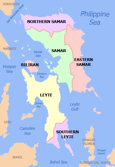
English: Political map of the Eastern Visayas Region, Philippines. Showing Biliran, Eastern Samar, Leyte, Hilagang Samar, Samar and Timog Leyte. Used the map template :Image:BlankMap-Philippines.png by User:TheCoffee. |
| Date | 3 May 2007 (original upload date) |
| Source | Transferred from en.wikipedia to Commons. |
| Author | Namayan at English Wikipedia |
Licensing[edit]
Namayan at English Wikipedia, the copyright holder of this work, hereby publishes it under the following licenses:

|
Permission is granted to copy, distribute and/or modify this document under the terms of the GNU Free Documentation License, Version 1.2 or any later version published by the Free Software Foundation; with no Invariant Sections, no Front-Cover Texts, and no Back-Cover Texts. A copy of the license is included in the section entitled GNU Free Documentation License. |
| This file is licensed under the Creative Commons Attribution-Share Alike 3.0 Unported license. | ||
| Attribution: Namayan at English Wikipedia | ||
| ||
| This licensing tag was added to this file as part of the GFDL licensing update. |
This file is licensed under the Creative Commons Attribution 2.5 Generic license.
Attribution: Namayan at English Wikipedia
- You are free:
- to share – to copy, distribute and transmit the work
- to remix – to adapt the work
- Under the following conditions:
- attribution – You must give appropriate credit, provide a link to the license, and indicate if changes were made. You may do so in any reasonable manner, but not in any way that suggests the licensor endorses you or your use.
You may select the license of your choice.
Original upload log[edit]
The original description page was here. All following user names refer to en.wikipedia.
| Date/Time | Dimensions | User | Comment |
|---|---|---|---|
| 2007-05-03 06:35 | 402×580× (37892 bytes) | Namayan | Political map of the [[Eastern Visayas|Eastern Visayas Region]], [[Philippines]]. Showing [[Biliran]], [[Eastern Samar]], [[Leyte]], [[Northern Samar]], [[Samar]] and [[Southern Leyte]]. Used the map template [[:Image:BlankMap-Philippines.png]] by [[User: |
File history
Click on a date/time to view the file as it appeared at that time.
| Date/Time | Thumbnail | Dimensions | User | Comment | |
|---|---|---|---|---|---|
| current | 19:16, 28 November 2021 | | 402 × 580 (37 KB) | Magog the Ogre (talk | contribs) | Reverted to version as of 13:53, 13 October 2021 (UTC) |
| 13:43, 25 November 2021 | No thumbnail | 2,000 × 2,899 (613 KB) | Sanchezph (talk | contribs) | Reverted to version as of 11:24, 28 March 2021 (UTC) | |
| 13:53, 13 October 2021 |  | 402 × 580 (37 KB) | AichiWikiFixer (talk | contribs) | Reverted to version as of 08:55, 30 March 2021 (UTC) | |
| 08:49, 13 October 2021 | No thumbnail | 402 × 580 (46 KB) | Emperor1991z (talk | contribs) | Update from Leyte Region formerly Eastern Visayas (May 9, 2022) | |
| 08:55, 30 March 2021 |  | 402 × 580 (37 KB) | HueMan1 (talk | contribs) | Reverted to version as of 15:35, 14 May 2020 (UTC) | |
| 11:24, 28 March 2021 | No thumbnail | 2,000 × 2,899 (613 KB) | Teamayuiyui (talk | contribs) | Update from 2021 | |
| 15:35, 14 May 2020 |  | 402 × 580 (37 KB) | HueMan1 (talk | contribs) | Reverted to version as of 23:26, 15 February 2016 (UTC) | |
| 21:52, 11 May 2020 | No thumbnail | 402 × 580 (104 KB) | Yuiyui2014 (talk | contribs) | 6 Provinces | |
| 23:26, 15 February 2016 |  | 402 × 580 (37 KB) | Melirius (talk | contribs) | Transferred from en.wikipedia |
You cannot overwrite this file.
File usage on Commons
The following 2 pages use this file:
File usage on other wikis
The following other wikis use this file:
- Usage on bcl.wikipedia.org
- Usage on cbk-zam.wikipedia.org
- Usage on en.wikipedia.org
- Usage on es.wikipedia.org
- Usage on hi.wikipedia.org
- Usage on ka.wikipedia.org
- ბილირანი
- აღმოსავლეთი ვისაიასი
- ტაკლობანი
- ორმოკი
- ბაიბაი
- ბორონგანი
- სამხრეთი ლეიტე
- ლეიტე (პროვინცია)
- სამარის პროვინცია
- ჩრდილოეთი სამარი
- თარგი:აღმოსავლეთი ვისაიასი
- ალმერია (ბილირანი)
- ბილირანი (ბილირანი)
- კაბუკგაიანი
- კაიბირანი
- კულაბა
- კავაიანი (ბილირანი)
- მარიპიპი
- ნავალი (ბილირანი)
- არტეჩე
- ბალანხიგა
- ბალანგკაიანი
- კან-ავიდი
- დოლორესი (აღმოსავლეთი სამარი)
- ხენერალ-მაკართური (აღმოსავლეთი სამარი)
- ხიპორლოსი
- გიუანი
View more global usage of this file.