File:Ph SOCCSKSARGEN.png
Jump to navigation
Jump to search
No higher resolution available.
Ph_SOCCSKSARGEN.png (361 × 490 pixels, file size: 28 KB, MIME type: image/png)
Captions
Captions
Add a one-line explanation of what this file represents

|
This map image could be re-created using vector graphics as an SVG file. This has several advantages; see Commons:Media for cleanup for more information. If an SVG form of this image is available, please upload it and afterwards replace this template with
{{vector version available|new image name}}.
It is recommended to name the SVG file “Ph SOCCSKSARGEN.svg”—then the template Vector version available (or Vva) does not need the new image name parameter. |
Summary[edit]
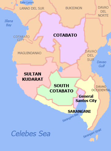
| Description | Political Map of SOCCSKSARGEN Region, Philippines. Showing Cotabato, Sarangani, South Cotabato, Sultan Kudarat, Cotabato City and General Santos City. Used the map template :Image:BlankMap-Philippines.png by User:TheCoffee. |
| Date | 3 May 2007 (original upload date) |
| Source | Own work |
| Author | Namayan at English Wikipedia |
Licensing[edit]
Namayan at English Wikipedia, the copyright holder of this work, hereby publishes it under the following licenses:

|
Permission is granted to copy, distribute and/or modify this document under the terms of the GNU Free Documentation License, Version 1.2 or any later version published by the Free Software Foundation; with no Invariant Sections, no Front-Cover Texts, and no Back-Cover Texts. A copy of the license is included in the section entitled GNU Free Documentation License. |
| This file is licensed under the Creative Commons Attribution-Share Alike 3.0 Unported license. | ||
| Attribution: Namayan at English Wikipedia | ||
| ||
| This licensing tag was added to this file as part of the GFDL licensing update. |
This file is licensed under the Creative Commons Attribution 2.5 Generic license.
Attribution: Namayan at English Wikipedia
- You are free:
- to share – to copy, distribute and transmit the work
- to remix – to adapt the work
- Under the following conditions:
- attribution – You must give appropriate credit, provide a link to the license, and indicate if changes were made. You may do so in any reasonable manner, but not in any way that suggests the licensor endorses you or your use.
You may select the license of your choice.
Original upload log[edit]
The original description page was here. All following user names refer to en.wikipedia.
File history
Click on a date/time to view the file as it appeared at that time.
| Date/Time | Thumbnail | Dimensions | User | Comment | |
|---|---|---|---|---|---|
| current | 04:46, 26 November 2021 | | 361 × 490 (28 KB) | Hariboneagle927 (talk | contribs) | Reverted to version as of 06:22, 5 September 2021 (UTC) |
| 03:48, 26 November 2021 |  | 2,000 × 2,768 (429 KB) | Nissan2020 (talk | contribs) | Reverted to version as of 11:35, 28 March 2021 (UTC) | |
| 06:22, 5 September 2021 |  | 361 × 490 (28 KB) | Emperor1991z (talk | contribs) | Reverted to version as of 17:10, 26 January 2019 (UTC) | |
| 08:56, 30 March 2021 |  | 361 × 490 (24 KB) | HueMan1 (talk | contribs) | Reverted to version as of 10:55, 27 January 2019 (UTC) | |
| 11:35, 28 March 2021 |  | 2,000 × 2,768 (429 KB) | Teamayuiyui (talk | contribs) | Update from 2021 | |
| 10:55, 27 January 2019 |  | 361 × 490 (24 KB) | Hariboneagle927 (talk | contribs) | Reverted to version as of 03:41, 7 December 2012 (UTC) | |
| 17:10, 26 January 2019 |  | 361 × 490 (28 KB) | Hariboneagle927 (talk | contribs) | Update. Cotabato City no longer part of the region. Plus Dav. Occidental borders outside the region. | |
| 03:41, 7 December 2012 |  | 361 × 490 (24 KB) | OgreBot (talk | contribs) | (BOT): Reverting to most recent version before archival | |
| 03:41, 7 December 2012 |  | 361 × 490 (33 KB) | OgreBot (talk | contribs) | (BOT): Uploading old version of file from en.wikipedia; originally uploaded on 2007-05-03 13:30:03 by Namayan | |
| 12:32, 6 December 2012 |  | 361 × 490 (24 KB) | MGA73bot2 (talk | contribs) | {{BotMoveToCommons|en.wikipedia|year={{subst:CURRENTYEAR}}|month={{subst:CURRENTMONTHNAME}}|day={{subst:CURRENTDAY}}}} == {{int:filedesc}} == {{Information |description=Political Map of SOCCSKSARGEN Region, [[:en:Philippines|Phili... |
You cannot overwrite this file.
File usage on Commons
The following 2 pages use this file:
File usage on other wikis
The following other wikis use this file:
- Usage on cbk-zam.wikipedia.org