File:Pf-map.gif
Jump to navigation
Jump to search
No higher resolution available.
Pf-map.gif (328 × 353 pixels, file size: 16 KB, MIME type: image/gif)
Captions
Captions
Add a one-line explanation of what this file represents
Summary
[edit]
| Description |
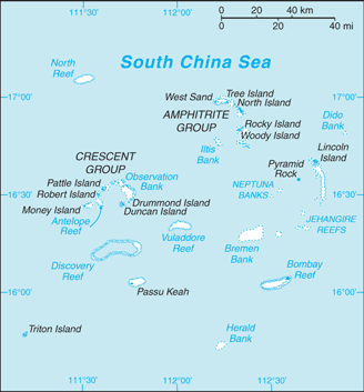
English: Map of the Paracel Islands from the CIA World Factbook |
| Source | https://cia.gov/library/publications/the-world-factbook/geos/pf.html |
| Author | CIA World Factbook |
| Other versions | File:ParacelIslands.png |
Licensing
[edit]
This image is in the public domain because it contains materials that originally came from the United States Central Intelligence Agency's World Factbook.
|
 |
File history
Click on a date/time to view the file as it appeared at that time.
| Date/Time | Thumbnail | Dimensions | User | Comment | |
|---|---|---|---|---|---|
| current | 15:23, 17 March 2011 | | 328 × 353 (16 KB) | David s graff~commonswiki (talk | contribs) | {{Information |Description ={{en|1=Map of the Paracel Islands from the CIA World Factbook}} |Source =https://cia.gov/library/publications/the-world-factbook/geos/pf.html |Author =CIA World Factbook |Date = |Permission = |o |
You cannot overwrite this file.
File usage on Commons
The following 2 pages use this file:
File usage on other wikis
The following other wikis use this file:
- Usage on lt.wikipedia.org